METAR & TAF 5W4
5W4 does not publish a METAR.
Showing the nearest reporting station: KFAY (FAYETTEVILLE RGNL/GRANNIS FLD) · 15.4 NM away. Conditions at 5W4 may differ.
METAR · KFAY
Observed 09:53Z
KFAY 270953Z AUTO 24003KT 10SM CLR 22/21 A2984 RMK AO2 SLP097 T02220211
- Wind
- 240° @ 3 kt
- Visibility
- 10 SM
- Temp / Dew
- 22°C / 21°C
- Altimeter
- 29.84 inHg
- Clouds
- CLR
- Density alt
- 1,316 ft
- Ceiling
- Unlimited
- Rules
- VFR
Airport info & contacts
Manager on record, flight service, ARTCC, attendance schedule and pattern altitude — published by the FAA and refreshed every 28 days.
Location
- From city
- 3 NM NE
- VFR sectional
- CHARLOTTE
- ARTCC
- ZDC · WASHINGTON
- NOTAM facility
- RDU (NOTAM-D)
Airport manager
- Name
- JOEY D'ANNUNZIO
- Phone
- (910) 904-0000
- Address
- 155 AIRPORT DRIVE, RAEFORD NC 28376
Flight service · Hours
- FSS RDU
- RALEIGH1-800-WX-BRIEF
- Attendance
- 0830-DUSK
Frequencies
Tap any row to copy the frequency to your clipboard.
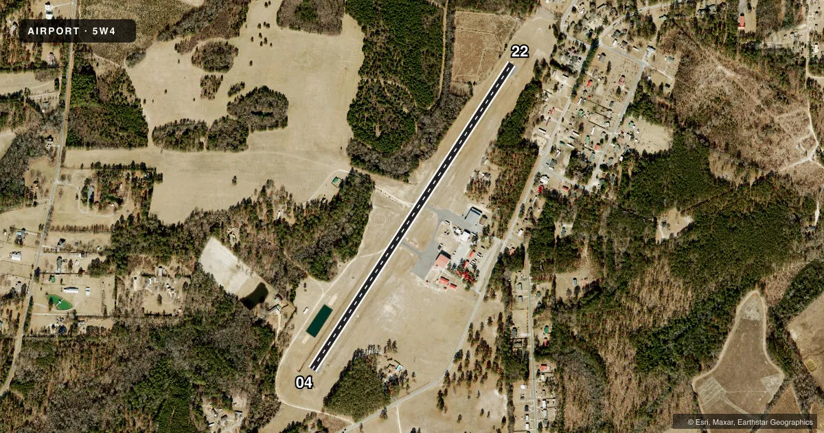
Runways & pattern
Full pagePattern entry · RWY 22
RIGHT TRAFFICRunway end performance
| End | TORA | TODA | ASDA | LDA | VGSI | Approach lights | Obstruction |
|---|---|---|---|---|---|---|---|
| 04 | — | — | — | — | — | — | 56', trees, 589' from thr, 84' R of cntrln, slope 6 |
| 22 | — | — | — | — | — | — | 39', trees, 615' from thr, 32' R of cntrln, slope 10 |
Declared distances in feet. TORA = takeoff run available, TODA = takeoff distance, ASDA = accelerate-stop, LDA = landing distance.
Airport sketch
Runways drawn to scale from FAA survey coordinates, rendered over satellite imagery. Not for navigation.
Approaches & charts
Services on the field
Fuel grades, oxygen, maintenance, ramp storage and lighting — as declared to the FAA by the airport operator.
Fuel & services
- Fuel
- 100LLA+
- Oxygen (bottled)
- Not available
- Oxygen (bulk)
- Not available
- Airframe repair
- Not available
- Power plant repair
- Not available
- Other services
- PAJA,SURV
Ramp & ground
- Transient storage
- Tie-down
- Landing fee
- No fee published
- Customs
- Not available
- Lighting schedule
- SS-SR
- Beacon schedule
- SS-SR
- Beacon
- White / Green (civil land)(WG)
- Wind indicator
- Lighted
- Segmented circle
- Yes
Fuel & FBOs
Cheapest 100LL and Jet A on the field and nearby. Always confirm with the FBO before taxi.
Airport notes
Surface conditions, obstructions, local procedures, lighting outages and other notes published with each FAA cycle.
General notes
- CTN: LOW FLYING MIL ACFT OPS IN VCNTY; ARPT LCTD WI FT. LIBERTY SOUTH B MOA.
- FQT PAJA TO TARGET 300 FT SE OF TRML APN.
- ACFT IN VCNTY MNT 123.5.
- FLY ONE MILE DOWNWIND LEG TO PREVENT CONFLICTS WITH PAJA (DROP ZONE SOUTHEAST FM RWY).
- AFT HRS SVC 910-578-4401.
- MNT FREQ 123.5 FOR PAJA.
- FOR CD CTC WASHINGTON ARTCC AT 703-771-3587.
- CTN DO NOT OVERFLY AIRPORT DUE TO PAJA.
Approach & departure obstructions
- 2220 FT BRUSH 0-200 FT FM THR 121 FT RIGHT OF CNTRLN.
Other notes
- THIS AIRPORT HAS BEEN SURVEYED BY THE NATIONAL GEODETIC SURVEY.
VFR map & nearby airports
VFR sectional. Tap any ICAO chip to open that airport.
Key facts · 5W4
Answer card- ICAO
- 5W4
- Name
- P K AIRPARK
- Location
- RAEFORD, NORTH CAROLINA
- Elevation
- 304 ft MSL
- Traffic pattern altitude
- 1,304 ft MSL (1,000 AGL)
- Control tower
- Non-towered (use CTAF)
- Total runways
- 1
- Longest runway
- 04/22 · 3,402 ft
- Published ILS approaches
- 0
- Published frequencies
- 4
- Magnetic variation
- 9°
- Current flight rules
- VFR
- Current wind
- 240° at 3 kt
- Favored runway now
- RWY 22
P K AIRPARK is in Raeford, North Carolina. Field elevation is 304 ft MSL. The airport has one runway, 04/22, which is 3,402 ft long and asphalt. There is no control tower. No ILS approaches are published here.
Pattern altitude is not published. Use the standard 1,000 ft AGL pattern for light piston traffic unless the current Chart Supplement says otherwise. The airport sits inside the Fort Liberty South Bravo MOA. Expect military traffic in the area. The published remarks also call out PAJA activity southeast of the runway. Do not overfly the airport. Fly one mile downwind leg to help avoid conflicts with the drop zone.
There are no on-field FBOs listed. After-hours service is available through the number in the Chart Supplement remarks. For current fuel and ramp support, contact the airport operator or the FBO directly by phone before you go. CTAF and UNICOM are both 123.0. The remarks also say aircraft in the vicinity should maintain 123.5 for PAJA activity. For clearance delivery, contact Washington ARTCC. The runway 22 end has a brush obstruction near the threshold, so give that end a close look during planning and landing checks.