METAR & TAF KFAY
Current METAR
Observed 05:53Z
KFAY 270553Z 20004KT 10SM CLR 23/22 A2988 RMK AO2 SLP112 T02330217 10278 20233 58002
- Wind
- 200° @ 4 kt
- Visibility
- 10 SM
- Temp / Dew
- 23°C / 22°C
- Altimeter
- 29.88 inHg
- Clouds
- CLR
- Density alt
- 1,244 ft
- Ceiling
- Unlimited
- Rules
- VFR
Airport info & contacts
Manager on record, flight service, ARTCC, attendance schedule and pattern altitude — published by the FAA and refreshed every 28 days.
Location
- From city
- 3 NM S
- VFR sectional
- CHARLOTTE
- ARTCC
- ZDC · WASHINGTON
- NOTAM facility
- FAY (NOTAM-D)
Airport manager
- Name
- ANDREW LAGALA
- Phone
- 910-433-1625
- Address
- 400 AIRPORT RD SUITE 1, FAYETTEVILLE NC 28306
Flight service · Hours
- FSS RDU
- RALEIGH1-800-WX-BRIEF
- Attendance
- 0600-0000
Frequencies
Tap any row to copy the frequency to your clipboard.
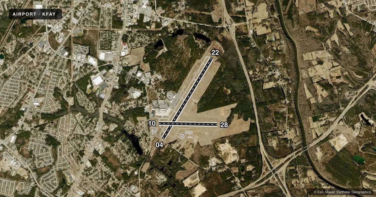
Runways & pattern
Full pagePattern entry · RWY 22
LEFT TRAFFIC| Runway | Heading (°M) | Length | Surface | Traffic |
|---|---|---|---|---|
| 04/22Favored | 24° / 204° | 7,709 ft | ASPH | Standard L |
| 10/28 | 84° / 264° | 4,801 ft | ASPH | Standard L |
Runway end performance
| End | TORA | TODA | ASDA | LDA | VGSI | Approach lights | Obstruction |
|---|---|---|---|---|---|---|---|
| 04 | 7,709' | 7,709' | 7,006' | 6,408' | PAPI 4-box right(3.13°) | MALSR | — |
| 22 | 7,709' | 7,709' | 6,711' | 6,408' | PAPI 4-box left(3°) | — | — |
| 10 | — | — | — | — | — | — | 15', trees, 800' from thr, 50' R of cntrln, slope 40 |
| 28 | — | — | — | — | PAPI 4-box left(3°) | — | 15', trees, 800' from thr, 90' R of cntrln, slope 40 |
Declared distances in feet. TORA = takeoff run available, TODA = takeoff distance, ASDA = accelerate-stop, LDA = landing distance.
Airport sketch
Runways drawn to scale from FAA survey coordinates, rendered over satellite imagery. Not for navigation.
Approaches & charts
ILS · 1
Services on the field
Fuel grades, oxygen, maintenance, ramp storage and lighting — as declared to the FAA by the airport operator.
Fuel & services
- Fuel
- 100LLA
- Oxygen (bottled)
- Not available
- Oxygen (bulk)
- Not available
- Airframe repair
- Major
- Power plant repair
- Major
- Other services
- AFRT,AVNCS,CARGO,CHTR,INSTR,RNTL,SALES
Ramp & ground
- Transient storage
- Tie-down
- Hangar
- Landing fee
- No fee published
- Customs
- Not available
- Lighting schedule
- SS-SR
- Beacon schedule
- SS-SR
- Beacon
- White / Green (civil land)(WG)
- Wind indicator
- Lighted
- Segmented circle
- No
Fuel & FBOs
Cheapest 100LL and Jet A on the field and nearby. Always confirm with the FBO before taxi.
Airport notes
Surface conditions, obstructions, local procedures, lighting outages and other notes published with each FAA cycle.
General notes
- CLSD TO ALL MIL ACFT OVER 17000 LBS FOR ACR RAMP OPNS EXCP 24 HR PPR. CALL AMGR 910-433-1160 MON-FRI.
Runway surface & condition
- 04/22PCR VALUE: 430/F/A/X/T
Other notes
- MAJOR POWER PLANT REPAIRS AVBL FOR PISTON ENGINES ONLY.
VFR map & nearby airports
VFR sectional. Tap any ICAO chip to open that airport.
Key facts · KFAY
Answer card- ICAO
- KFAY
- Name
- FAYETTEVILLE RGNL/GRANNIS FLD
- Location
- FAYETTEVILLE, NORTH CAROLINA
- Elevation
- 189.4 ft MSL
- Traffic pattern altitude
- 1,189.4 ft MSL (1,000 AGL)
- Control tower
- Towered · 24
- Total runways
- 2
- Longest runway
- 04/22 · 7,709 ft
- Published ILS approaches
- 1
- Published frequencies
- 20
- Magnetic variation
- 7°
- Current flight rules
- VFR
- Current wind
- 200° at 4 kt
- Favored runway now
- RWY 22
Fayetteville Rgnl/Grannis Fld sits in Fayetteville, North Carolina. Field elevation is 189.4 ft MSL. The airport has two asphalt runways. The longest is 7,709 ft on 04/22. Runway 10/28 is 4,801 ft. The tower is open 24 hours. One ILS is published for runway 04. Pattern altitude is not published in the facts. Use the current FAA Chart Supplement for the published traffic pattern altitude before you fly.
Signature Aviation is on the field. It carries 100LL and Jet A. The airport is a good fit for a range of piston and turbine traffic. The published remarks also note major power plant repairs for piston engines only. That can matter if you are planning maintenance or need help after a mechanical issue. Another published remark limits certain military ramp operations over 17,000 lb unless prior permission is arranged. If that affects your flight, call the airport manager before arrival.
KFAY sits in a controlled environment with Class C service on the published frequencies. Expect normal towered-airport discipline. Review the current Chart Supplement for any noise or curfew restrictions before flying in. Check the approach and runway setup before departure. Runway 04 has the published ILS.