METAR & TAF KCPC
Current METAR
Observed 10:35Z
KCPC 271035Z AUTO 33001KT 4SM BR CLR 21/21 A2989 RMK AO2
- Wind
- 330° @ 1 kt
- Visibility
- 4 SM
- Temp / Dew
- 21°C / 21°C
- Altimeter
- 29.89 inHg
- Clouds
- CLR
- Density alt
- 880 ft
- Ceiling
- Unlimited
- Rules
- MVFR
Airport info & contacts
Manager on record, flight service, ARTCC, attendance schedule and pattern altitude — published by the FAA and refreshed every 28 days.
Location
- From city
- 3 NM S
- VFR sectional
- CHARLOTTE
- ARTCC
- ZJX · JACKSONVILLE
- NOTAM facility
- CPC (NOTAM-D)
Airport manager
- Name
- PHIL EDWARDS
- Phone
- 910-642-6187
- Address
- 467 AIRPORT ROAD, WHITEVILLE NC 28472
Flight service · Hours
- FSS RDU
- RALEIGH1-800-WX-BRIEF
- Attendance
- MON-SAT · 0800-1800
- SUN · 0900-1800
Frequencies
Tap any row to copy the frequency to your clipboard.
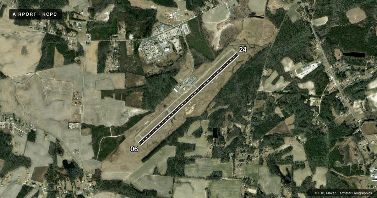
Runways & pattern
Full pagePattern entry · RWY 06
LEFT TRAFFICRunway end performance
| End | TORA | TODA | ASDA | LDA | VGSI | Approach lights | Obstruction |
|---|---|---|---|---|---|---|---|
| 06 | — | — | — | — | PAPI 2-box left(3°) | — | 77', trees, 2007' from thr, 405' R of cntrln, slope 23 |
| 24 | — | — | — | — | PAPI 2-box left(3.25°) | — | 66', trees, 2195' from thr, 138' R of cntrln, slope 30 |
Declared distances in feet. TORA = takeoff run available, TODA = takeoff distance, ASDA = accelerate-stop, LDA = landing distance.
Airport sketch
Runways drawn to scale from FAA survey coordinates, rendered over satellite imagery. Not for navigation.
Approaches & charts
Services on the field
Fuel grades, oxygen, maintenance, ramp storage and lighting — as declared to the FAA by the airport operator.
Fuel & services
- Fuel
- 100LLA1+
- Oxygen (bottled)
- Not available
- Oxygen (bulk)
- Not available
- Airframe repair
- Not available
- Power plant repair
- Not available
Ramp & ground
- Transient storage
- Tie-down
- Landing fee
- No fee published
- Customs
- Not available
- Lighting schedule
- SEE RMK
- Beacon schedule
- SS-SR
- Beacon
- White / Green (civil land)(WG)
- Wind indicator
- Lighted
- Segmented circle
- Yes
Fuel & FBOs
Cheapest 100LL and Jet A on the field and nearby. Always confirm with the FBO before taxi.
Airport notes
Surface conditions, obstructions, local procedures, lighting outages and other notes published with each FAA cycle.
General notes
- DEER AND TURKEYS ON INVOF ARPT.
- ARPT UNATNDD EASTER SUNDAY, 4TH JULY, THANKSGIVING DAY, CHRISTMAS EVE AND CHRISTMAS DAY.
- NO OFF-PAVEMENT LDG ALLOWED.
- FOR CD CTC MYRTLE BEACH APCH AT 843-477-2727 OR 843-477-2704, WHEN APCH CLSD CTC JACKSONVILLE ARTCC AT 904-845-1592.
Lighting notes
- ACTVT REIL RWY 06 & 24; MIRL RWY 06/24 - CTAF. PAPI RWY 06 & 24 ON CONSLY.
Fuel notes
- 100LLFUEL 24 HR CREDIT CARD SVC AVBL.
Other notes
- VFR OPERATIONS ONLY.
- 1FOR EMERGENCY SERVICE AFTER HRS CALL 910-654-3389 OR 910-625-5489.
VFR map & nearby airports
VFR sectional. Tap any ICAO chip to open that airport.
Key facts · KCPC
Answer card- ICAO
- KCPC
- Name
- COLUMBUS COUNTY RGNL
- Location
- WHITEVILLE, NORTH CAROLINA
- Elevation
- 99.4 ft MSL
- Traffic pattern altitude
- 1,099.4 ft MSL (1,000 AGL)
- Control tower
- Non-towered (use CTAF)
- Total runways
- 1
- Longest runway
- 06/24 · 5,500 ft
- Published ILS approaches
- 0
- Published frequencies
- 4
- Magnetic variation
- 7°
- Current flight rules
- MVFR
- Current wind
- 330° at 1 kt
- Favored runway now
- RWY 06
Columbus County Rgnl sits in Whiteville, North Carolina. Field elevation is 99.4 ft MSL. The airport has one runway, 06/24, which is 5,500 ft long. There is no control tower. Traffic pattern altitude is not published, so use the standard 1,000 ft AGL for light piston operations unless the current Chart Supplement says otherwise.
No ILS approaches are published here. This is a VFR-only field, so plan your arrival with that in mind. The airport sits in flat coastal plain country, so the main issues are local traffic, wildlife and staying sharp on the CTAF. Deer and turkeys are reported on and near the airport. No off-pavement landing is allowed.
Columbus County is the on-field FBO. It carries 100LL and Jet A. Fuel is available 24 hours with credit card service. Runway end identifier lights are on runways 06 and 24. Medium intensity runway lights are on 06/24 and are controlled on CTAF. Precision approach path indicators are also installed on both ends and are on continuously.
For clearance delivery, contact Myrtle Beach Approach. If approach is closed, use Jacksonville Center. Check the current FAA Chart Supplement for any operational changes before you go. The field is unattended on Easter Sunday, 4th of July, Thanksgiving Day, Christmas Eve, Christmas Day.