METAR & TAF KCRE
Current METAR
Observed 08:53Z
KCRE 270853Z AUTO 00000KT 10SM FEW021 23/22 A2984 RMK AO2 SLP106 T02280222 55006
- Wind
- 000° @ 0 kt
- Visibility
- 10 SM
- Temp / Dew
- 23°C / 22°C
- Altimeter
- 29.84 inHg
- Clouds
- FEW
- Density alt
- 1,098 ft
- Ceiling
- Unlimited
- Rules
- VFR
Airport info & contacts
Manager on record, flight service, ARTCC, attendance schedule and pattern altitude — published by the FAA and refreshed every 28 days.
Location
- From city
- 1 NM NW
- VFR sectional
- CHARLOTTE
- ARTCC
- ZJX · JACKSONVILLE
- NOTAM facility
- CRE (NOTAM-D)
Airport manager
- Name
- JUDI OLMSTEAD
- Phone
- 843-448-1580
- Address
- 1100 JETPORT ROAD, MYRTLE BEACH SC 29577
Flight service · Hours
- FSS AND
- ANDERSON1-800-WX-BRIEF
- Attendance
- 0700-2100
Frequencies
Tap any row to copy the frequency to your clipboard.
Runways & pattern
Full pagePattern entry · RWY 05
LEFT TRAFFICRunway end performance
| End | TORA | TODA | ASDA | LDA | VGSI | Approach lights | Obstruction |
|---|---|---|---|---|---|---|---|
| 05 | — | — | — | — | PAPI 2-box left(3°) | — | 59', trees, 1434' from thr, 273' R of cntrln, slope 20 |
| 23 | — | — | — | — | PAPI 2-box right(2.98°) | MALSR | 98', trees, 3450' from thr, 672' R of cntrln, slope 33 |
Declared distances in feet. TORA = takeoff run available, TODA = takeoff distance, ASDA = accelerate-stop, LDA = landing distance.
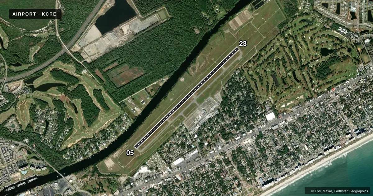
Airport sketch
Runways drawn to scale from FAA survey coordinates, rendered over satellite imagery. Not for navigation.
Approaches & charts
ILS · 1
Services on the field
Fuel grades, oxygen, maintenance, ramp storage and lighting — as declared to the FAA by the airport operator.
Fuel & services
- Fuel
- 100LLA
- Oxygen (bottled)
- Not available
- Oxygen (bulk)
- Not available
- Airframe repair
- Not available
- Power plant repair
- Not available
- Other services
- CHTR,INSTR,RNTL
Ramp & ground
- Transient storage
- Tie-down
- Hangar
- Landing fee
- No fee published
- Customs
- Not available
- Lighting schedule
- SEE RMK
- Beacon schedule
- SS-SR
- Beacon
- White / Green (civil land)(WG)
- Wind indicator
- Lighted
- Segmented circle
- Yes
Fuel & FBOs
Cheapest 100LL and Jet A on the field and nearby. Always confirm with the FBO before taxi.
Airport notes
Surface conditions, obstructions, local procedures, lighting outages and other notes published with each FAA cycle.
General notes
- EXTENSIVE BANNER TOW OPERATIONS FM ARPT ALONG COAST LINE 10 NM NE TO 20 NM SW.
- GULLS ON & INVOF ARPT.
- FOR CD WHEN ATCT CLSD CTC MYRTLE BEACH APCH AT 843-477-2727/2704. WHEN MYR APCH CLSD CTC JACKSONVILLE ARTCC AT 904-845-1592.
Lighting notes
- AFTER 0000 ACTVT HIRL RY 05/23; REIL RY 05 AND MALSR RY 23 - CTAF.
Other notes
- EXISTED PRIOR TO 1958.
VFR map & nearby airports
VFR sectional. Tap any ICAO chip to open that airport.
Key facts · KCRE
Answer card- ICAO
- KCRE
- Name
- GRAND STRAND
- Location
- NORTH MYRTLE BEACH, SOUTH CAROLINA
- Elevation
- 31.6 ft MSL
- Traffic pattern altitude
- 1,031.6 ft MSL (1,000 AGL)
- Control tower
- Towered · 0700-2100
- Total runways
- 1
- Longest runway
- 05/23 · 5,997 ft
- Published ILS approaches
- 1
- Published frequencies
- 10
- Magnetic variation
- 8°
- Current flight rules
- VFR
- Current wind
- 000° at 0 kt
- Favored runway now
- –
Grand Strand is in North Myrtle Beach, South Carolina. Field elevation is 31.6 ft MSL. The airport has one runway, 05/23, which is 5,997 ft long and paved asphalt. The control tower is open from 0700 to 2100. The published ILS serves runway 23. Pattern altitude is not published, so use the standard 1,000 ft AGL for light piston traffic unless ATC or the current Chart Supplement says otherwise.
Beach Aviation Services is on the field. It carries 100LL, Jet A and Jet A Prist. If you are arriving after the tower closes, the published remarks say to contact Myrtle Beach Approach for clearance delivery. If Approach is closed, contact Jacksonville ARTCC. The airport also has extensive banner tow activity along the coastline. That matters for both arrival planning and local traffic scanning.
Expect a coastal environment at low elevation. Gulls are reported on and near the airport. After 0000, the high intensity runway lights on 05/23 are activated. Runway end identifier lights are on runway 05. The approach lighting system with runway alignment indicator lights is on runway 23. Use the common traffic advisory frequency when the tower is closed.