METAR & TAF KGGE
Current METAR
Observed 09:35Z
KGGE 270935Z AUTO 00000KT 4SM BR CLR 23/23 A2984 RMK AO2
- Wind
- 000° @ 0 kt
- Visibility
- 4 SM
- Temp / Dew
- 23°C / 23°C
- Altimeter
- 29.84 inHg
- Clouds
- CLR
- Density alt
- 1,108 ft
- Ceiling
- Unlimited
- Rules
- MVFR
Airport info & contacts
Manager on record, flight service, ARTCC, attendance schedule and pattern altitude — published by the FAA and refreshed every 28 days.
Location
- From city
- 3 NM S
- VFR sectional
- CHARLOTTE
- ARTCC
- ZJX · JACKSONVILLE
- NOTAM facility
- GGE (NOTAM-D)
Airport manager
- Name
- JIM TAYLOR
- Phone
- 843-545-3638
- Address
- 129 AIRPORT RD., GEORGETOWN SC 29440
Flight service · Hours
- FSS AND
- ANDERSON1-800-WX-BRIEF
- Attendance
- 0700-2100
Frequencies
Tap any row to copy the frequency to your clipboard.
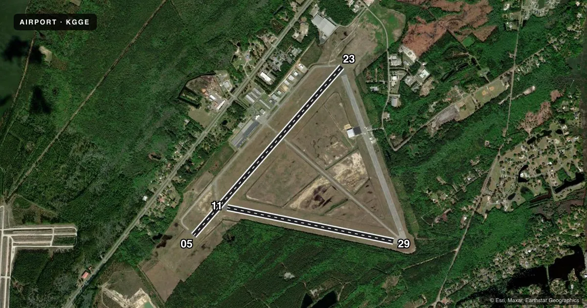
Runways & pattern
Full pagePattern entry · RWY 05
LEFT TRAFFIC| Runway | Heading (°M) | Length | Surface | Traffic |
|---|---|---|---|---|
| 05/23 | 33° / 213° | 6,005 ft | ASPH | Standard L |
| 11/29 | 93° / 273° | 4,539 ft | ASPH | Standard L |
Runway end performance
| End | TORA | TODA | ASDA | LDA | VGSI | Approach lights | Obstruction |
|---|---|---|---|---|---|---|---|
| 05 | — | — | — | — | PAPI 2-box left(3°) | ODALS | — |
| 23 | — | — | — | — | PAPI 2-box left(3°) | — | 68', tree, 2149' from thr, 349' R of cntrln, slope 28 |
| 29 | — | — | — | — | — | — | 104', tree, 1408' from thr, 38' R of cntrln, slope 11 |
Declared distances in feet. TORA = takeoff run available, TODA = takeoff distance, ASDA = accelerate-stop, LDA = landing distance.
Airport sketch
Runways drawn to scale from FAA survey coordinates, rendered over satellite imagery. Not for navigation.
Approaches & charts
Services on the field
Fuel grades, oxygen, maintenance, ramp storage and lighting — as declared to the FAA by the airport operator.
Fuel & services
- Fuel
- 100LLA
- Oxygen (bottled)
- High pressure
- Airframe repair
- Major
- Power plant repair
- Major
- Other services
- INSTR,RNTL
Ramp & ground
- Transient storage
- Tie-down
- Hangar
- Landing fee
- No fee published
- Customs
- Not available
- Lighting schedule
- SEE RMK
- Beacon schedule
- SS-SR
- Beacon
- White / Green (civil land)(WG)
- Wind indicator
- Lighted
- Segmented circle
- Yes
Fuel & FBOs
Cheapest 100LL and Jet A on the field and nearby. Always confirm with the FBO before taxi.
Airport notes
Surface conditions, obstructions, local procedures, lighting outages and other notes published with each FAA cycle.
General notes
- GCO AVBL ON FREQ 121.725 THRU MYR CD.
- RY 11/29 CLSD TO ACFT 12,500 LBS & OVER.
- FOR CD IF UNA VIA GCO CTC JACKSONVILLE ARTCC AT 904-845-1592.
Lighting notes
- ACTVT RY 5/23 MIRL, PAPI RY 5 & RY 23, REIL RY 05 AND ODALS RY 05 0300-1000 - CTAF.
Runway surface & condition
- 05/23PCR VALUE: 220/F/A/X/T
Other notes
- EXISTED PRIOR TO 1958.
- MANAGERFBO - SEVEN RIVERS AVIATION, 843-527-7516.
- MANAGERFAX NUMBER 843-545-3413
- 11/29RWY SFC IS VERY RUF WITH GRASS GROWING THRU THE CRACKS.
VFR map & nearby airports
VFR sectional. Tap any ICAO chip to open that airport.
Key facts · KGGE
Answer card- ICAO
- KGGE
- Name
- GEORGETOWN COUNTY
- Location
- GEORGETOWN, SOUTH CAROLINA
- Elevation
- 39.5 ft MSL
- Traffic pattern altitude
- 1,039.5 ft MSL (1,000 AGL)
- Control tower
- Non-towered (use CTAF)
- Total runways
- 2
- Longest runway
- 05/23 · 6,005 ft
- Published ILS approaches
- 0
- Published frequencies
- 4
- Magnetic variation
- 8°
- Current flight rules
- MVFR
- Current wind
- 000° at 0 kt
- Favored runway now
- –
Georgetown County Airport sits in Georgetown, South Carolina. Field elevation is 39.5 ft MSL. The airport has two asphalt runways. The longest is 6,005 ft on runway 05/23. There is no control tower. Pattern altitude is not published, so use the standard 1,000 ft AGL for light piston traffic unless the current Chart Supplement says otherwise. No ILS approaches are published here.
Seven Rivers Aviation is the on-field FBO. It carries 100LL and Jet A Prist. Call them at (843) 527-7516 before arrival if you need ramp or fuel status. Runway 05/23 has medium intensity lighting. It also has PAPI on both ends, runway end identifier lights on runway 05 and an omnidirectional approach lighting system from 0300 to 1000 on CTAF. Runway 11/29 is shorter at 4,539 ft. The published remarks also note that runway 11/29 has a very rough surface with grass growing through the cracks. It is closed to aircraft over 12,500 lb.
This is an uncontrolled field with Myrtle Beach approach frequencies in the area. Expect to work CTAF 123.0 and verify current procedures before you go. The airport has been around since before 1958. For any current noise, lighting, or operational changes, check the current FAA Chart Supplement or call the airport operator or Seven Rivers Aviation directly.