METAR & TAF KPHH
KPHH does not publish a METAR.
Showing the nearest reporting station: KGGE (GEORGETOWN COUNTY) · 13.3 NM away. Conditions at KPHH may differ.
METAR · KGGE
Observed 10:55Z
KGGE 271055Z AUTO 00000KT 7SM CLR 23/22 A2986 RMK AO2
- Wind
- 000° @ 0 kt
- Visibility
- 7 SM
- Temp / Dew
- 23°C / 22°C
- Altimeter
- 29.86 inHg
- Clouds
- CLR
- Density alt
- 1,067 ft
- Ceiling
- Unlimited
- Rules
- VFR
Airport info & contacts
Manager on record, flight service, ARTCC, attendance schedule and pattern altitude — published by the FAA and refreshed every 28 days.
Location
- From city
- 2 NM E
- VFR sectional
- CHARLOTTE
- ARTCC
- ZJX · JACKSONVILLE
- NOTAM facility
- AND (NOTAM-D)
Airport manager
- Name
- JIM TAYLOR
- Phone
- 843-545-3638
- Address
- 129 AIRPORT ROAD, GEORGETOWN SC 29440
Flight service · Hours
- FSS AND
- ANDERSON1-800-WX-BRIEF
- Attendance
- Unattended
Frequencies
Tap any row to copy the frequency to your clipboard.
Runways & pattern
Full pagePattern entry · RWY 18
LEFT TRAFFICRunway end performance
| End | TORA | TODA | ASDA | LDA | VGSI | Approach lights | Obstruction |
|---|---|---|---|---|---|---|---|
| 18 | — | — | — | — | PAPI 2-box left(3°) | — | 24', tree, 352' from thr, 83' R of cntrln, slope 6 |
| 36 | — | — | — | — | PAPI 2-box left(3°) | — | — |
Declared distances in feet. TORA = takeoff run available, TODA = takeoff distance, ASDA = accelerate-stop, LDA = landing distance.
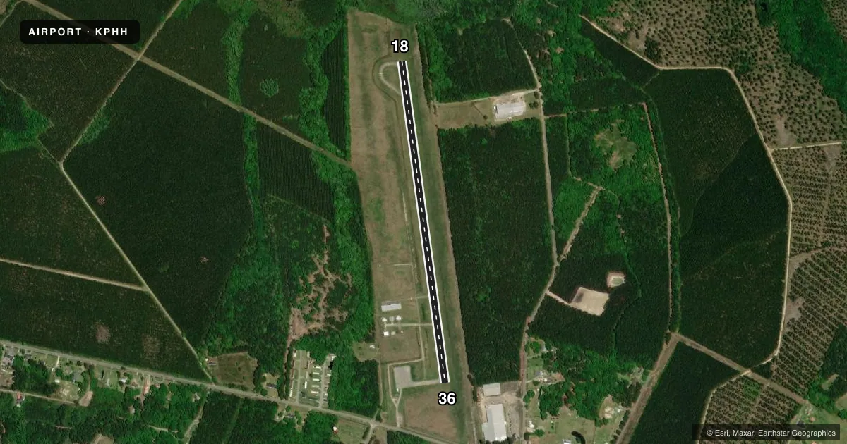
Airport sketch
Runways drawn to scale from FAA survey coordinates, rendered over satellite imagery. Not for navigation.
Approaches & charts
Services on the field
Fuel grades, oxygen, maintenance, ramp storage and lighting — as declared to the FAA by the airport operator.
Fuel & services
- Fuel
- Not available
- Oxygen (bottled)
- Not available
- Oxygen (bulk)
- Not available
- Airframe repair
- Not available
- Power plant repair
- Not available
Ramp & ground
- Transient storage
- Tie-down
- Landing fee
- No fee published
- Customs
- Not available
- Lighting schedule
- SS-SR
- Beacon schedule
- SS-SR
- Beacon
- White / Green (civil land)(WG)
- Wind indicator
- Lighted
- Segmented circle
- Yes
Fuel & FBOs
Cheapest 100LL and Jet A on the field and nearby. Always confirm with the FBO before taxi.
Airport notes
Surface conditions, obstructions, local procedures, lighting outages and other notes published with each FAA cycle.
General notes
- FOR CD CTC MYRTLE BEACH APCH AT 843-477-2727 OR 843-477-2704, WHEN APCH CLSD CTC JACKSONVILLE ARTCC AT 904-845-1592.
VFR map & nearby airports
VFR sectional. Tap any ICAO chip to open that airport.
Key facts · KPHH
Answer card- ICAO
- KPHH
- Name
- ROBERT F SWINNIE
- Location
- ANDREWS, SOUTH CAROLINA
- Elevation
- 26.4 ft MSL
- Traffic pattern altitude
- 1,026.4 ft MSL (1,000 AGL)
- Control tower
- Non-towered (use CTAF)
- Total runways
- 1
- Longest runway
- 18/36 · 3,001 ft
- Published ILS approaches
- 0
- Published frequencies
- 3
- Magnetic variation
- 6°
- Current flight rules
- VFR
- Current wind
- 000° at 0 kt
- Favored runway now
- –
Robert F Swinnie is in Andrews, South Carolina. The field elevation is 26.4 ft MSL. It has one runway, 18/36, which is 3,001 ft long and asphalt. There is no control tower. No ILS approaches are published here. The pattern altitude is not published, so use the standard 1,000 ft AGL for light piston traffic unless the current Chart Supplement says otherwise.
For radio work, CTAF is 122.9. Approach and departure service is on Myrtle Beach frequencies 127.4 and 257.95. For clearance delivery, contact Myrtle Beach Approach at the published phone numbers before departure. When approach is closed, Jacksonville ARTCC handles that call. There are no on-field FBOs listed in the facts. Confirm services with the airport operator or on CTAF before you go.
This is a low-elevation field with a short single runway. That means planning matters if you are bringing in a heavier airplane or flying on a hot day. Check performance carefully. Also verify current airspace, any local procedures and any noise or operating notes in the current Chart Supplement before you launch.