METAR & TAF KMKS
Current METAR
Observed 12:15Z
KMKS 271215Z AUTO 00000KT 7SM CLR 25/24 A2986 RMK AO2
- Wind
- 000° @ 0 kt
- Visibility
- 7 SM
- Temp / Dew
- 25°C / 24°C
- Altimeter
- 29.86 inHg
- Clouds
- CLR
- Density alt
- 1,366 ft
- Ceiling
- Unlimited
- Rules
- VFR
Airport info & contacts
Manager on record, flight service, ARTCC, attendance schedule and pattern altitude — published by the FAA and refreshed every 28 days.
Location
- From city
- 1 NM SW
- VFR sectional
- CHARLOTTE
- ARTCC
- ZJX · JACKSONVILLE
- NOTAM facility
- AND (NOTAM-D)
Airport manager
- Name
- STACY THOMAS
- Phone
- (843) 719-4751
- Address
- 616 WHITESVILLE ROAD, MONCKS CORNER SC 29461
Flight service · Hours
- FSS AND
- ANDERSON1-800-WX-BRIEF
- Attendance
- SUN-THUR · 0800-1800
- FRI-SAT · 0800-1800
Frequencies
Tap any row to copy the frequency to your clipboard.
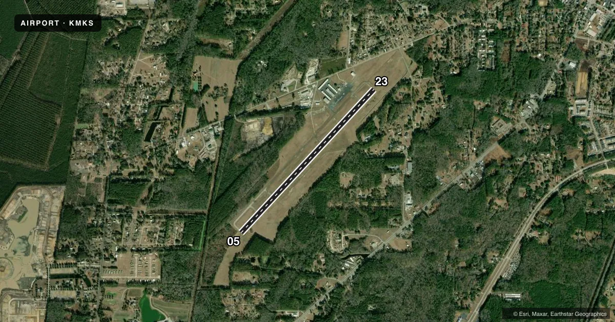
Runways & pattern
Full pagePattern entry · RWY 05
LEFT TRAFFICRunway end performance
| End | TORA | TODA | ASDA | LDA | VGSI | Approach lights | Obstruction |
|---|---|---|---|---|---|---|---|
| 05 | — | — | — | — | — | — | 42', tree, 625' from thr, 34' R of cntrln, slope 10 |
| 23 | — | — | — | — | PAPI 2-box left(3°) | — | 97', tree, 1898' from thr, 500' R of cntrln, slope 17 |
Declared distances in feet. TORA = takeoff run available, TODA = takeoff distance, ASDA = accelerate-stop, LDA = landing distance.
Airport sketch
Runways drawn to scale from FAA survey coordinates, rendered over satellite imagery. Not for navigation.
Approaches & charts
Services on the field
Fuel grades, oxygen, maintenance, ramp storage and lighting — as declared to the FAA by the airport operator.
Fuel & services
- Fuel
- 100LLA
- Oxygen (bottled)
- Not available
- Oxygen (bulk)
- Not available
- Airframe repair
- Major
- Power plant repair
- Major
- Other services
- INSTR,RNTL
Ramp & ground
- Transient storage
- Tie-down
- Hangar
- Landing fee
- No fee published
- Customs
- Not available
- Lighting schedule
- SEE RMK
- Beacon schedule
- SS-SR
- Beacon
- White / Green (civil land)(WG)
- Wind indicator
- Lighted
- Segmented circle
- Yes
Fuel & FBOs
Cheapest 100LL and Jet A on the field and nearby. Always confirm with the FBO before taxi.
Airport notes
Surface conditions, obstructions, local procedures, lighting outages and other notes published with each FAA cycle.
General notes
- CTN: MIL AND CHS TFC IN VCNTY.
- WILDLIFE ON AND INVOF ARPT WITH INCR ACT AT DUSK AND DAWN.
- FOR CD CTC CHARLESTON APCH AT 843-414-2832.
Lighting notes
- ACTVT MIRL RWY 05/23 - CTAF.
VFR map & nearby airports
VFR sectional. Tap any ICAO chip to open that airport.
Key facts · KMKS
Answer card- ICAO
- KMKS
- Name
- BERKELEY COUNTY
- Location
- MONCKS CORNER, SOUTH CAROLINA
- Elevation
- 74 ft MSL
- Traffic pattern altitude
- 1,074 ft MSL (1,000 AGL)
- Control tower
- Non-towered (use CTAF)
- Total runways
- 1
- Longest runway
- 05/23 · 5,001 ft
- Published ILS approaches
- 0
- Published frequencies
- 4
- Magnetic variation
- 7°
- Current flight rules
- VFR
- Current wind
- 000° at 0 kt
- Favored runway now
- –
Berkeley County Airport sits in Moncks Corner, South Carolina. The field elevation is 74 ft MSL. It has one runway. Runway 05/23 is 5,001 ft long with concrete pavement. There is no control tower. No ILS approaches are published. Pattern altitude is not published, so use the standard 1,000 ft AGL for light piston operations unless the current Chart Supplement says otherwise.
Berkeley County Airport is served by Charleston Approach for approach and departure. Published frequencies include 121.275 and 379.925 for Charleston Approach or Departure. CTAF and UNICOM are both 123.05. The on-field FBO is Berkeley County Airport. It carries 100LL and Jet A with Prist. Call (843) 899-7711 for current service details.
A few local items matter here. The Chart Supplement notes military and Charleston traffic in the vicinity, so keep your scan sharp on arrival and departure. Wildlife is also reported on and near the airport, with more activity at dusk and dawn. Runway 05/23 has medium intensity lights that are activated by CTAF. For clearance delivery, contact Charleston Approach at 843-414-2832. This is a low-elevation field with a single 5,001 ft runway, so it is straightforward for most light aircraft. Still, verify current procedures before you go.