METAR & TAF KJZI
Current METAR
Observed 03:55Z
KJZI 270355Z AUTO 00000KT 10SM BKN013 26/24 A2987 RMK AO2 LTG DSNT E
- Wind
- 000° @ 0 kt
- Visibility
- 10 SM
- Temp / Dew
- 26°C / 24°C
- Altimeter
- 29.87 inHg
- Clouds
- BKN
- Density alt
- 1,405 ft
- Ceiling
- 1,300 ft AGL
- Rules
- MVFR
Airport info & contacts
Manager on record, flight service, ARTCC, attendance schedule and pattern altitude — published by the FAA and refreshed every 28 days.
Location
- From city
- 6 NM SW
- VFR sectional
- CHARLOTTE
- ARTCC
- ZJX · JACKSONVILLE
- NOTAM facility
- AND (NOTAM-D)
Airport manager
- Name
- ELLIOTT SUMMEY
- Phone
- 843-767-7000
- Address
- 5500 INTERNATIONAL BLVD, #101, CHARLESTON SC 29418
Flight service · Hours
- FSS AND
- ANDERSON1-800-WX-BRIEF
- Attendance
- 0600-2200
Frequencies
Tap any row to copy the frequency to your clipboard.
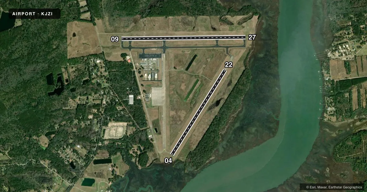
Runways & pattern
Full pagePattern entry · RWY 09
LEFT TRAFFIC| Runway | Heading (°M) | Length | Surface | Traffic |
|---|---|---|---|---|
| 09/27 | 84° / 264° | 5,350 ft | CONC | Standard L |
| 04/22 | 27° / 207° | 4,313 ft | CONC | Standard L |
Runway end performance
| End | TORA | TODA | ASDA | LDA | VGSI | Approach lights | Obstruction |
|---|---|---|---|---|---|---|---|
| 09 | — | — | — | — | PAPI 4-box left(3°) | — | 110', trees, 3589' from thr, 781' R of cntrln, slope 30 |
| 27 | — | — | — | — | PAPI 4-box right(3°) | — | 16', brush, 438' from thr, 250' R of cntrln, slope 14 |
| 04 | — | — | — | — | — | — | 83', tree, 2221' from thr, 50' R of cntrln, slope 24 |
Declared distances in feet. TORA = takeoff run available, TODA = takeoff distance, ASDA = accelerate-stop, LDA = landing distance.
Airport sketch
Runways drawn to scale from FAA survey coordinates, rendered over satellite imagery. Not for navigation.
Approaches & charts
ILS · 1
Services on the field
Fuel grades, oxygen, maintenance, ramp storage and lighting — as declared to the FAA by the airport operator.
Fuel & services
- Fuel
- 100LLA
- Oxygen (bulk)
- Not available
- Airframe repair
- Minor
- Power plant repair
- Minor
- Other services
- INSTR,RNTL
Ramp & ground
- Transient storage
- Tie-down
- Hangar
- Landing fee
- No fee published
- Customs
- Not available
- Lighting schedule
- SEE RMK
- Beacon schedule
- SS-SR
- Beacon
- White / Green (civil land)(WG)
- Wind indicator
- Lighted
- Segmented circle
- Yes
Fuel & FBOs
Cheapest 100LL and Jet A on the field and nearby. Always confirm with the FBO before taxi.
Airport notes
Surface conditions, obstructions, local procedures, lighting outages and other notes published with each FAA cycle.
General notes
- DEER & BIRDS ON & INVOF ARPT.
- FOR CD CTC CHARLESTON APCH AT 843-414-2832.
Lighting notes
- SR-SS, TO ACTVT AND INCR INTST REIL RWY 09 & 27; HIRL RWY 09/27; MIRL RWY 04/22 - CTAF. SR-SS, PAPI RWY 09 & 27 OPR CONSLY. SS-SR, REIL RWY 09 & 27; PAPI RWY 09 & 27; HIRL RWY 09/27 OPR CONSLY, TO INCR INTST - CTAF. SS-SR, TO ACTVT MIRL RWY 04/22 - CTAF.
Approach & departure obstructions
- 04TREE LINE 231 FEET EAST OF RWY 4 THLD 21 FEET HIGH
- 27APPROACH SLOPE TO DISPLACED THR. IS 50:1.
Other notes
- ARPT EXISTED PRIOR TO 1958
- SUPPLEMENTARY LGTD WINDCONES RWYS 04, 22, 09 & 27.
VFR map & nearby airports
VFR sectional. Tap any ICAO chip to open that airport.
Key facts · KJZI
Answer card- ICAO
- KJZI
- Name
- CHARLESTON EXEC
- Location
- CHARLESTON, SOUTH CAROLINA
- Elevation
- 18.6 ft MSL
- Traffic pattern altitude
- 1,018.6 ft MSL (1,000 AGL)
- Control tower
- Non-towered (use CTAF)
- Total runways
- 2
- Longest runway
- 09/27 · 5,350 ft
- Published ILS approaches
- 1
- Published frequencies
- 5
- Magnetic variation
- 5°
- Current flight rules
- MVFR
- Current wind
- 000° at 0 kt
- Favored runway now
- –
Charleston Exec is in Charleston, South Carolina. The field elevation is 18.6 ft MSL. It has two concrete runways. The longest is runway 09/27 at 5,350 ft. There is no control tower. One ILS is published for runway 09.
Pattern altitude is not published in the facts. Use the standard 1,000 ft AGL for light piston traffic unless the current FAA Chart Supplement says otherwise. The airport uses CTAF 122.8. Charleston Approach handles clearance delivery. The published remarks also note deer and birds on and near the airport. That matters here. Keep your scan active on departure and in the pattern.
Atlantic Aviation is on field. It carries 100LL, Jet A and Jet A Prist. If you need current ramp or fuel details, call them directly at (843) 559-2401. Runway 04 has a tree line 231 ft east of the threshold. Runway 27 has a displaced-threshold approach slope note. The lighting setup is pilot-controlled through CTAF. Runway 09 and 27 have PAPI and high intensity lights. Runway 04 and 22 use medium intensity lights. For a first trip, plan for a busy coastal airport environment and verify any current procedures in the FAA Chart Supplement before you go.