METAR & TAF KRBW
Current METAR
Observed 20:35Z
KRBW 262035Z AUTO 08011KT SCT037 BKN045 OVC050 29/25 A2988 RMK AO2 PWINO TSNO
- Wind
- 080° @ 11 kt
- Visibility
- —
- Temp / Dew
- 29°C / 25°C
- Altimeter
- 29.88 inHg
- Clouds
- OVC
- Density alt
- 1,855 ft
- Ceiling
- 4,500 ft AGL
- Rules
- VFR
Airport info & contacts
Manager on record, flight service, ARTCC, attendance schedule and pattern altitude — published by the FAA and refreshed every 28 days.
Location
- From city
- 2 NM NE
- VFR sectional
- CHARLOTTE
- ARTCC
- ZJX · JACKSONVILLE
- NOTAM facility
- AND (NOTAM-D)
Airport manager
- Name
- BERT DUFFIE
- Phone
- 843-549-2549
- Address
- 537 AVIATION WAY, WALTERBORO SC 29488
Flight service · Hours
- FSS AND
- ANDERSON1-800-WX-BRIEF
- Attendance
- 0800-1800
Frequencies
Tap any row to copy the frequency to your clipboard.
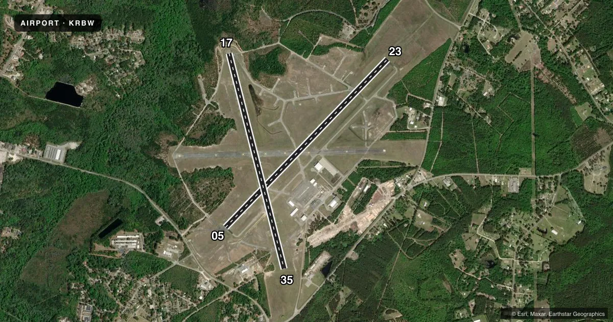
Runways & pattern
Full pagePattern entry · RWY 05
LEFT TRAFFIC| Runway | Heading (°M) | Length | Surface | Traffic |
|---|---|---|---|---|
| 05/23Favored | 39° / 219° | 6,002 ft | ASPH-CONC | Standard L |
| 17/35 | 161° / 341° | 5,705 ft | ASPH-CONC | Standard L |
Runway end performance
| End | TORA | TODA | ASDA | LDA | VGSI | Approach lights | Obstruction |
|---|---|---|---|---|---|---|---|
| 05 | 6,002' | 6,002' | 6,002' | 6,002' | PAPI 2-box left(3.5°) | — | 82', trees, 1999' from thr, 265' R of cntrln, slope 21 |
| 23 | 6,002' | 6,002' | 5,977' | 5,977' | PAPI 2-box left(3°) | ODALS | 99', trees, 2932' from thr, 751' R of cntrln, slope 27 |
| 17 | — | — | — | — | — | — | 59', tree, 1984' from thr, 229' R of cntrln, slope 30 |
| 35 | — | — | — | — | — | — | 43', tree, 1214' from thr, 308' R of cntrln, slope 23 |
Declared distances in feet. TORA = takeoff run available, TODA = takeoff distance, ASDA = accelerate-stop, LDA = landing distance.
Airport sketch
Runways drawn to scale from FAA survey coordinates, rendered over satellite imagery. Not for navigation.
Approaches & charts
ILS · 1
Services on the field
Fuel grades, oxygen, maintenance, ramp storage and lighting — as declared to the FAA by the airport operator.
Fuel & services
- Fuel
- 100LLA
- Oxygen (bottled)
- Not available
- Oxygen (bulk)
- Not available
- Airframe repair
- Major
- Power plant repair
- Major
- Other services
- INSTR,PAJA
Ramp & ground
- Transient storage
- Tie-down
- Hangar
- Landing fee
- No fee published
- Customs
- Not available
- Lighting schedule
- SEE RMK
- Beacon schedule
- SS-SR
- Beacon
- White / Green (civil land)(WG)
- Wind indicator
- Lighted
- Segmented circle
- No
Fuel & FBOs
Cheapest 100LL and Jet A on the field and nearby. Always confirm with the FBO before taxi.
Airport notes
Surface conditions, obstructions, local procedures, lighting outages and other notes published with each FAA cycle.
General notes
- FOR CD CTC CHARLESTON APCH AT 843 414-2832.
- DEER ON AND INVOF ARPT WITH INCR ACT DRG NGT AND AT DUSK AND DAWN.
Lighting notes
- ODALS RWY 23; REILS RWY 23; PAPI RWY 05 & 23; MIRLS RWY 05/23 - OPR CONSLY FM DUSK-2200. FM 2200 TO DAWN ACTVT ODALS RWY 23; MIRLS RWY 05/23 - CTAF.
Fuel notes
- 100LL100LL SELF-SVC FUEL AVBL 24 HRS.
- AFOR AFT HRS SVC CALL 843-549-2549.
Other notes
- ARPT EXISTED PRIOR TO 1958.
- (WIND INDCR) SUPPLRY LGTD WINDCONES RWY 23 AND MIDFIELD.
- 1CLSD CHRISTMAS DAY.
VFR map & nearby airports
VFR sectional. Tap any ICAO chip to open that airport.
Key facts · KRBW
Answer card- ICAO
- KRBW
- Name
- LOWCOUNTRY RGNL
- Location
- WALTERBORO, SOUTH CAROLINA
- Elevation
- 100.9 ft MSL
- Traffic pattern altitude
- 1,100.9 ft MSL (1,000 AGL)
- Control tower
- Non-towered (use CTAF)
- Total runways
- 2
- Longest runway
- 05/23 · 6,002 ft
- Published ILS approaches
- 1
- Published frequencies
- 4
- Magnetic variation
- 5°
- Current flight rules
- VFR
- Current wind
- 080° at 11 kt
- Favored runway now
- RWY 05
Lowcountry Rgnl (KRBW) sits in Walterboro, South Carolina. Field elevation is 100.9 ft MSL. The airport has two asphalt-concrete runways. The longest is runway 05/23 at 6,002 ft. Runway 17/35 is 5,705 ft. There is no control tower. For clearance delivery, Charleston Approach handles it. The published pattern altitude is not listed, so use the standard 1,000 ft AGL for light piston operations unless the current Chart Supplement says otherwise.
Runway 23 has the published ILS approach. The field also has runway lighting that stays on from dusk to 2200. After 2200, the runway lights and the approach lighting on 23 are activated by CTAF. Runway 23 also has REILs and PAPI. Lighted windcones are on runway 23 and midfield. One on-field FBO is listed. Lowcountry Regional Airport carries 100LL and Jet A Prist. 100LL self-service is available 24 hours. If you need after-hours service, call the FBO directly.
This is a good airport to brief carefully at night or near dusk. Deer are reported on and near the airport. That matters most in the low-light window. Check the current Chart Supplement for any noise or curfew restrictions before flying into the field. Use the current sectional or TAC for airspace details if you need them before departure.