METAR & TAF 7S1
7S1 does not publish a METAR.
Showing the nearest reporting station: KAQX (ALLENDALE COUNTY) · 3.1 NM away. Conditions at 7S1 may differ.
METAR · KAQX
Observed 06:35Z
KAQX 270635Z AUTO 00000KT 1SM BR BKN002 24/24 A2985 RMK AO2
- Wind
- 000° @ 0 kt
- Visibility
- 1 SM
- Temp / Dew
- 24°C / 24°C
- Altimeter
- 29.85 inHg
- Clouds
- BKN
- Density alt
- 1,338 ft
- Ceiling
- 200 ft AGL
- Rules
- LIFR
Airport info & contacts
Manager on record, flight service, ARTCC, attendance schedule and pattern altitude — published by the FAA and refreshed every 28 days.
Location
- From city
- 3 NM NE
- VFR sectional
- CHARLOTTE
- ARTCC
- ZJX · JACKSONVILLE
- NOTAM facility
- AND (NOTAM-D)
Airport manager
- Name
- LARRY SHUMARD
- Phone
- 208-794-6052
- Address
- 190 MAPLE DR, FAIRFAX SC 29827
Flight service · Hours
- FSS AND
- ANDERSON1-800-WX-BRIEF
Frequencies
Tap any row to copy the frequency to your clipboard.
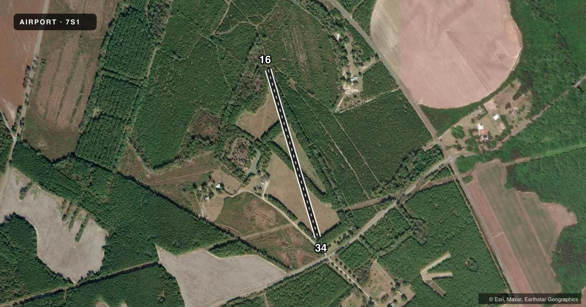
Runways & pattern
Full pagePattern entry · RWY 16
RIGHT TRAFFICAirport sketch
Runways drawn to scale from FAA survey coordinates, rendered over satellite imagery. Not for navigation.
Approaches & charts
Services on the field
Fuel grades, oxygen, maintenance, ramp storage and lighting — as declared to the FAA by the airport operator.
Fuel & services
- Fuel
- Not available
Ramp & ground
- Transient storage
- Not published
Fuel & FBOs
Cheapest 100LL and Jet A on the field and nearby. Always confirm with the FBO before taxi.
Airport notes
Surface conditions, obstructions, local procedures, lighting outages and other notes published with each FAA cycle.
General notes
- PRVDD VFR USE.
Other notes
- OWNERATTN OF: LARRY SHUMARD
VFR map & nearby airports
VFR sectional. Tap any ICAO chip to open that airport.
Key facts · 7S1
Answer card- ICAO
- 7S1
- Name
- 7 OAKS FLIGHT PARK
- Location
- FAIRFAX, SOUTH CAROLINA
- Elevation
- 138 ft MSL
- Traffic pattern altitude
- 1,138 ft MSL (1,000 AGL)
- Control tower
- Non-towered (use CTAF)
- Total runways
- 1
- Longest runway
- 16/34 · 2,350 ft
- Published ILS approaches
- 0
- Published frequencies
- 1
- Magnetic variation
- –
- Current flight rules
- LIFR
- Current wind
- 000° at 0 kt
- Favored runway now
- –
7 Oaks Flight Park sits in Fairfax, South Carolina. The field elevation is 138 ft MSL. It has one runway. Runway 16/34 is 2,350 ft of turf. Plan for grass-field performance and check the surface condition before you go.
This is an untowered airport. CTAF is 122.9. No ILS approaches are published. The pattern altitude is not published in the facts, so use the standard 1,000 ft AGL pattern for light piston operations unless the current Chart Supplement says otherwise. The airport is listed for VFR use. Published remarks also note the attention of Larry Shumard.
For a first-time arrival, the main things are the turf runway, the short length and the lack of tower services. Check the current Chart Supplement for any local procedures, noise notes, or other operating remarks before departure. If you need current field status or local coordination, contact the airport operator directly.