METAR & TAF 3J1
Current METAR
Observed 10:35Z
K3J1 271035Z AUTO 00000KT 5SM BR SCT001 23/23 A2985 RMK AO2
- Wind
- 000° @ 0 kt
- Visibility
- 5 SM
- Temp / Dew
- 23°C / 23°C
- Altimeter
- 29.85 inHg
- Clouds
- SCT
- Density alt
- 1,152 ft
- Ceiling
- Unlimited
- Rules
- MVFR
Airport info & contacts
Manager on record, flight service, ARTCC, attendance schedule and pattern altitude — published by the FAA and refreshed every 28 days.
Location
- From city
- 1 NM NW
- VFR sectional
- CHARLOTTE
- ARTCC
- ZJX · JACKSONVILLE
- NOTAM facility
- AND (NOTAM-D)
Airport manager
- Name
- LEONARD SANSONE
- Phone
- 843-226-0399
- Address
- 262 HON. BARBARA B. CLARK DR., PO BOX 653, RIDGELAND SC 29936
Flight service · Hours
- FSS AND
- ANDERSON1-800-WX-BRIEF
- Attendance
- MON -SUN · 0800-1800
Frequencies
Tap any row to copy the frequency to your clipboard.
Runways & pattern
Full pagePattern entry · RWY 18
LEFT TRAFFICRunway end performance
| End | TORA | TODA | ASDA | LDA | VGSI | Approach lights | Obstruction |
|---|---|---|---|---|---|---|---|
| 18 | — | — | — | — | PAPI 2-box left(3°) | — | — |
| 36 | — | — | — | — | PAPI 2-box left(3°) | — | — |
Declared distances in feet. TORA = takeoff run available, TODA = takeoff distance, ASDA = accelerate-stop, LDA = landing distance.
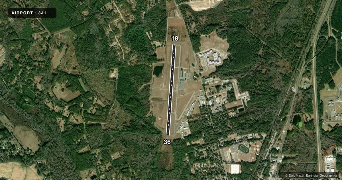
Airport sketch
Runways drawn to scale from FAA survey coordinates, rendered over satellite imagery. Not for navigation.
Approaches & charts
Services on the field
Fuel grades, oxygen, maintenance, ramp storage and lighting — as declared to the FAA by the airport operator.
Fuel & services
- Fuel
- 100LLAA+
- Oxygen (bottled)
- Not available
- Oxygen (bulk)
- Not available
- Airframe repair
- Minor
- Power plant repair
- Minor
- Other services
- GLD,TOW
Ramp & ground
- Transient storage
- Tie-down
- Landing fee
- No fee published
- Customs
- Not available
- Lighting schedule
- SEE RMK
- Beacon schedule
- SS-SR
- Beacon
- White / Green (civil land)(WG)
- Wind indicator
- Lighted
- Segmented circle
- Yes
Fuel & FBOs
Cheapest 100LL and Jet A on the field and nearby. Always confirm with the FBO before taxi.
Airport notes
Surface conditions, obstructions, local procedures, lighting outages and other notes published with each FAA cycle.
General notes
- GLIDER OPNS INVOF ARPT.
- FOR CD CTC BEAUFORT APCH AT 843-228-6298, WHEN APCH CLSD CTC JACKSONVILLE ARTCC AT 904-845-1592.
- FBO LCTD MID-FLD.
- RWY 36 CALM WIND RWY.
Lighting notes
- MIRL RWY 18/36 PRESET LOW INTST; TO INCR INTST CTAF. REIL RWY 18 & 36; PAPI RWY 18 & 36 OPR CONSLY DUSK-DAWN.
Fuel notes
- A+JET A WITH PRIST.
Approach & departure obstructions
- 36TREE, 10 FT TALL, 166 FT FROM THRESHOLD, 125 FT LEFT OF CENTERLINE
- 18RWY 18 PAPI UNUSBL BYD 8 DEGS LEFT OF RCL.
- 3650 FT TREES 100-150 FT RIGHT OF CNTRLN 1000 FT FM THR.
Other notes
- ARPT EXISTED PRIOR TO 1958.
- 1SUN, MON - ON CALL. 843-929-4159 FOR AFTER HOURS FEE AND AVAIL.
- 1SKYBLUE AVIATION FBO.
VFR map & nearby airports
VFR sectional. Tap any ICAO chip to open that airport.
Key facts · 3J1
Answer card- ICAO
- 3J1
- Name
- RIDGELAND-CLAUDE DEAN
- Location
- RIDGELAND, SOUTH CAROLINA
- Elevation
- 84.8 ft MSL
- Traffic pattern altitude
- 1,084.8 ft MSL (1,000 AGL)
- Control tower
- Non-towered (use CTAF)
- Total runways
- 1
- Longest runway
- 18/36 · 4,200 ft
- Published ILS approaches
- 0
- Published frequencies
- 2
- Magnetic variation
- 4°
- Current flight rules
- MVFR
- Current wind
- 000° at 0 kt
- Favored runway now
- –
Ridgeland-Claude Dean Airport (3J1) sits in Ridgeland, South Carolina. Field elevation is 84.8 ft MSL. The airport has one runway. Runway 18/36 is 4,200 ft long with asphalt pavement. There is no control tower. CTAF and UNICOM are both 123.075.
No ILS approaches are published here. Pattern altitude is not published, so use the standard 1,000 ft AGL for light piston traffic unless current local guidance says otherwise. SkyBlue Aviation is the on-field FBO. It is located mid-field. It carries 100LL and Jet A with Prist. On Sunday and Monday it is on call, so plan ahead if you need after-hours support.
A few operational items matter here. Glider operations are in the vicinity of the airport. Runway 36 is the calm wind runway. There are trees near the departure end of runway 36, including a 50-foot tree line right of centerline and a small tree close to the threshold area. Runway 18 has PAPI available. The PAPI on runway 18 is unusable beyond 8 degrees left of centerline. The runway lights are preset to low intensity. Use the CTAF to increase intensity. For clearance delivery, contact Beaufort Approach. If Approach is closed, contact Jacksonville ARTCC.