METAR & TAF KSAV
Current METAR
Observed 08:53Z
KSAV 270853Z AUTO 29005KT 10SM SCT110 26/23 A2985 RMK AO2 SLP106 T02560233 58004
- Wind
- 290° @ 5 kt
- Visibility
- 10 SM
- Temp / Dew
- 26°C / 23°C
- Altimeter
- 29.85 inHg
- Clouds
- SCT
- Density alt
- 1,469 ft
- Ceiling
- Unlimited
- Rules
- VFR
Airport info & contacts
Manager on record, flight service, ARTCC, attendance schedule and pattern altitude — published by the FAA and refreshed every 28 days.
Location
- From city
- 7 NM NW
- VFR sectional
- ATLANTA
- ARTCC
- ZJX · JACKSONVILLE
- NOTAM facility
- SAV (NOTAM-D)
Airport manager
- Name
- GREG B. KELLY, A.A.E.
- Phone
- 912-964-0514
- Address
- 400 AIRWAYS AVE., SAVANNAH GA 31408
Flight service · Hours
- FSS MCN
- MACON1-800-WX-BRIEF
- Attendance
- 1100-0300Z++
Frequencies
Tap any row to copy the frequency to your clipboard.
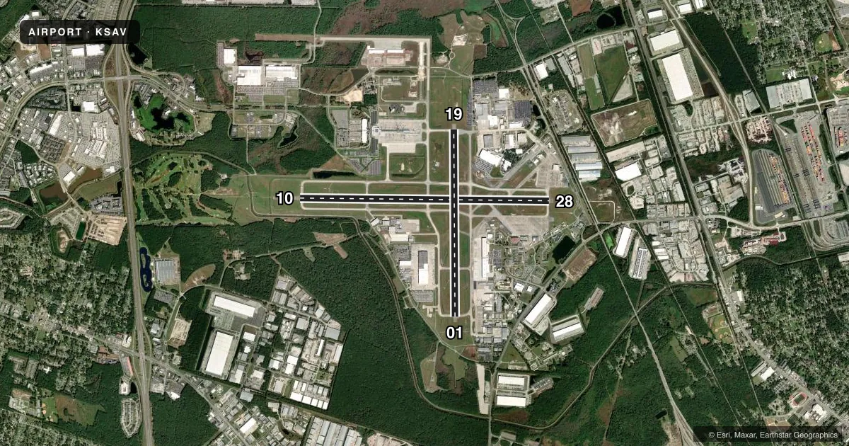
Runways & pattern
Full pagePattern entry · RWY 28
LEFT TRAFFIC| Runway | Heading (°M) | Length | Surface | Traffic |
|---|---|---|---|---|
| 10/28Favored | 85° / 265° | 9,351 ft | CONC | Standard L |
| 01/19 | 354° / 174° | 7,002 ft | CONC | Standard L |
Runway end performance
| End | TORA | TODA | ASDA | LDA | VGSI | Approach lights | Obstruction |
|---|---|---|---|---|---|---|---|
| 10 | 9,351' | 9,351' | 9,351' | 9,351' | PAPI 4-box left(3°) | MALSR | — |
| 28 | 9,351' | 9,351' | 9,351' | 9,351' | PAPI 4-box left(3°) | — | — |
| 01 | 7,002' | 7,002' | 7,002' | 7,002' | PAPI 4-box left(3°) | — | — |
| 19 | 7,002' | 7,002' | 7,002' | 7,002' | VASI 4-box right(3°) | — | — |
Declared distances in feet. TORA = takeoff run available, TODA = takeoff distance, ASDA = accelerate-stop, LDA = landing distance.
Airport sketch
Runways drawn to scale from FAA survey coordinates, rendered over satellite imagery. Not for navigation.
Approaches & charts
ILS · 2
Services on the field
Fuel grades, oxygen, maintenance, ramp storage and lighting — as declared to the FAA by the airport operator.
Fuel & services
- Fuel
- 100LLAA+A++
- Oxygen (bottled)
- HIGH/LOW
- Oxygen (bulk)
- HIGH/LOW
- Airframe repair
- Major
- Power plant repair
- Major
- Other services
- AFRT,CARGO,CHTR,INSTR,RNTL,SALES
Ramp & ground
- Transient storage
- Tie-down
- Hangar
- Landing fee
- No fee published
- Customs
- Not available
- Lighting schedule
- SEE RMK
- Beacon schedule
- SS-SR
- Beacon
- White / Green (civil land)(WG)
- Wind indicator
- Lighted
- Segmented circle
- Yes
Fuel & FBOs
Cheapest 100LL and Jet A on the field and nearby. Always confirm with the FBO before taxi.
Airport notes
Surface conditions, obstructions, local procedures, lighting outages and other notes published with each FAA cycle.
General notes
- PILOTS CONDUCTING EFVS OPS; BE AWARE LED ALS IN USE RWY 10.
- BIRDS & DEER ON & INVOF OF ARPT. AIR CARRIER ACFT CTC GND PRIOR TO PUSH BACK FROM ALL GATES. PILOTS SHOULD COMPLETE ALL CALCULATIONS PRIOR TO PUSH BACK FM TRML GATE. OPR TRANSPONDERS WITH ALT REPORTING MODE AND ADS-B (IF EQUIPPED) ENABLED ON ALL AIRPORT SURFACES.
- NO 180 DEG TURNS ON ASPH FOR ACFT OVER 12500 LBS GROSS.
- PPR FOR ACES OF GEN AVN ACFT ON THE ACR TRML RAMP CTC 912-964-7501.
- TWY A, TWY B TWY C, TWY D, TWY E, TWY F, TWY G AND TWY H ARE LTD TO DUAL WHEEL ACFT UP TO 173,000 LBS AND DUAL TANDEM WHEEL ACFT UP TO 310,000 LBS.
- TWY B2, C2 ARE LIMITED TO 12500 LBS.
- TWY E CLSD FM RY 28 TO BUT NOT INCLUDING TWY E2 TO ACFT WITH WING SPAN OF 175 FT OR GREATER.
- TWY 'E2' CONNECTOR CLSD TO ACFT LANDING RY 28. DISTANCE FM TOUCHDOWN TOO SHORT FOR SAFE TURN.
- ANG: COMBAT READINESS TRNG CNTR (CRTC)/AIR DOMINANCE CENTER (ADC) AFLD MGMT DSN 860-3145/3497, C912-963-3145/3497. DUTY HR 1230-2100Z++ MON-FRI. CTC ADC BASE OPS ON UHF 253.20 (CALL SIGN "ADC OPS").
- 165AW (C130 UNIT) AFLD MGMT DSN 860-8184/8433, C912-966-8184. DUTY HR 1230-2100Z++MON-THUR, 1230-1900Z++ FRI. ACFT INBD TO 165AW CTC COMD POST DSN 860-8244, C912-966-8244 OR UHF 225.75 WITHIN 50 NM WITH ETA AND REQ. ADC COMSEC STORAGE UNAVBL. 165AW COMSEC STORAGE UP TO SECRET AVBL VIA COMD POST DUR NORMAL DUTY HR ONLY.
- TRAN ALERT: TRAN ACFT PROHIBITED WHEN TRAN ALERT UNAVBL. FLEET SVC UNAVBL.
- ACFT/VEHICLES ON THE SOUTH END OF TWY A AND THE EAST END OF TWY E NOT VSB FROM THE ATCT.
- BASH PHASE II 01 APR - 31 OCT. CTC TWR OR COMD POST FOR BIRD HAZ. WILDLIFE MOST ACTIVE +/- 1 HR OF SS OR SR.
- ANG: MIL E2 TAXILANE.
- FOR CD IF UNA TO CTC ON FSS FREQ, CTC SAVANNAH APCH AT 912-964-3205, WHEN APCH CLSD CTC JACKSONVILLE ARTCC AT 904-845-1592.
- ARPT CLSD TO INTL GA ARR EXC 24HR PPR CTC US CUST 912-232-7507 OR 912-210-0348 AND SERVICING FIXED BASE OPR FOR PROCESSING AND INSTRUCTIONS.
- MILITARY: A-GEAR BAK-12B CABLE RAISED BY BAK-14M DEVICE O/R TO TWR.
Lighting notes
- WHEN ATCT CLSD ACTVT MALSR RWY 10; REIL RWYS 19 & 28; HIRL RWYS 01/19 & 10/28 - CTAF. VASI RWY 19 AND PAPI RWYS 01, 10, & 28 OPER CONTINUOUSLY.
Fuel notes
- AFUEL: A++100(MIL), (NC-100LL).
- A+AVBL 1100-0300Z++ C912-964-1557, OT 2 HR PN, C912-313-6310. SVC FEE.
Runway surface & condition
- 01/19PCR VALUE: 567/R/B/W/T
- 10/28PCR VALUE: 576/R/B/W/T
Approach & departure obstructions
- 10MALSR RWY 10 NSTD SPACING.
- 01NO RVR WHEN ATCT CLSD.
- 10NO RVR WHEN ATCT CLSD.
- 19NO RVR WHEN ATCT CLSD.
- 28NO RVR WHEN ATCT CLSD.
Arresting gear
- 10_BAK-12BAK-12 BAK 14M(B) (1500FT).
- 28_BAK-12BAK-12 BAK 14M(B) (1977 FT).
Other notes
- US CUST NR: 912-210-0348 OR 912-232-7507.
- MILITARY JET-OVHDS 2000 FT.
- 01/19RY 1/19 CENTER 75 FT KEEL SECTION OF RY CONCRETE FULL LENGTH; LAST 500 FT CONCRETE, FULL WIDTH, BOTH ENDS. ALL TWY INTERSECTIONS CONCRETE EXCEPT TWY B AT THE NORTH END OF THE RY AND TWY B2. REMAINDER OF RY 1/19 ASPHALT.
- 10/28RY 10/28 CENTER 75 FT KEEL SECTION CONCRETE FULL LENGTH; ALL TWY INTERSECTIONS CONCRETE EXCEPT TWY C2 AND C3. REMAINDER OF RY 10/28 ASPHALT.
VFR map & nearby airports
VFR sectional. Tap any ICAO chip to open that airport.
Key facts · KSAV
Answer card- ICAO
- KSAV
- Name
- SAVANNAH/HILTON HEAD INTL
- Location
- SAVANNAH, GEORGIA
- Elevation
- 50.2 ft MSL
- Traffic pattern altitude
- 1,050.2 ft MSL (1,000 AGL)
- Control tower
- Towered · 0600-0000
- Total runways
- 2
- Longest runway
- 10/28 · 9,351 ft
- Published ILS approaches
- 2
- Published frequencies
- 26
- Magnetic variation
- 6°
- Current flight rules
- VFR
- Current wind
- 290° at 5 kt
- Favored runway now
- RWY 28
Savannah/Hilton Head Intl is in Savannah, Georgia. Field elevation is 50.2 ft MSL. The airport has two runways. The longest is 9,351 ft on runway 10/28. Tower service is available from 0600 to 0000. Two ILS approaches are published. They serve runway ends 01 and 10.
Pattern altitude is not published in the facts, so use standard 1,000 ft AGL for light piston traffic unless the current Chart Supplement says otherwise. On the field, Signature Aviation and Sheltair both carry 100LL, Jet A and Jet A Prist. If you are planning a first stop here, pay attention to the terminal ramp rules. Prior permission is required for general aviation aircraft on the aircraft terminal ramp. International GA arrivals are closed except with 24-hour prior permission. Call U.S. Customs and the servicing FBO before you go if that applies to your trip.
This is a busy Class C field with airline traffic, military activity and wildlife considerations. Birds and deer are reported on and near the airport. Wildlife is most active around sunrise and sunset. The tower also notes that aircraft and vehicles on the south end of taxiway A and the east end of taxiway E are not visible from the tower. Runway 10 has LED approach lighting with nonstandard spacing. If you are flying EFVS, brief that before arrival.