METAR & TAF KTBR
Current METAR
Observed 08:35Z
KTBR 270835Z AUTO 29002KT 10SM CLR 24/24 A2984 RMK AO2
- Wind
- 290° @ 2 kt
- Visibility
- 10 SM
- Temp / Dew
- 24°C / 24°C
- Altimeter
- 29.84 inHg
- Clouds
- CLR
- Density alt
- 1,411 ft
- Ceiling
- Unlimited
- Rules
- VFR
Airport info & contacts
Manager on record, flight service, ARTCC, attendance schedule and pattern altitude — published by the FAA and refreshed every 28 days.
Location
- From city
- 3 NM NE
- VFR sectional
- ATLANTA
- ARTCC
- ZJX · JACKSONVILLE
- NOTAM facility
- TBR (NOTAM-D)
Airport manager
- Name
- KATHY BOYKIN
- Phone
- 912-764-9083
- Address
- 601 AIRPORT BLVD, STATESBORO GA 30461
Flight service · Hours
- FSS MCN
- MACON1-800-WX-BRIEF
- Attendance
- MON-FRI · 0800-1900
- SAT-SUN · 0900-1700
Frequencies
Tap any row to copy the frequency to your clipboard.
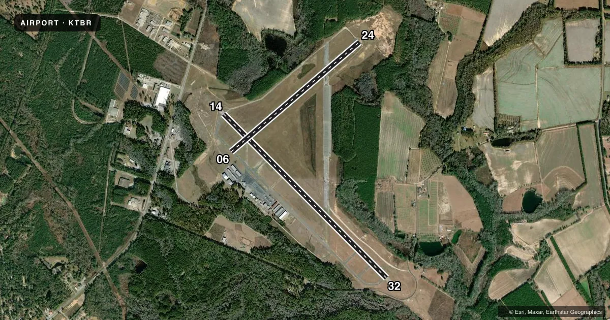
Runways & pattern
Full pagePattern entry · RWY 32
LEFT TRAFFIC| Runway | Heading (°M) | Length | Surface | Traffic |
|---|---|---|---|---|
| 14/32Favored | 130° / 310° | 6,000 ft | ASPH | Standard L |
| 06/24 | 45° / 225° | 4,382 ft | ASPH | Standard L |
Runway end performance
| End | TORA | TODA | ASDA | LDA | VGSI | Approach lights | Obstruction |
|---|---|---|---|---|---|---|---|
| 14 | 6,000' | 6,000' | 6,000' | 6,000' | PAPI 2-box left(4°) | — | 72', trees, 1793' from thr, 637' R of cntrln, slope 22 |
| 32 | 6,000' | 6,000' | 6,000' | 5,701' | PAPI 2-box left(3°) | MALSR | 15', road, 380' from thr, 540' R of cntrln, slope 12 |
| 06 | — | — | — | — | — | — | 78', trees, 1729' from thr, 385' R of cntrln, slope 19 |
| 24 | — | — | — | — | — | — | 72', trees, 1126' from thr, 300' R of cntrln, slope 12 |
Declared distances in feet. TORA = takeoff run available, TODA = takeoff distance, ASDA = accelerate-stop, LDA = landing distance.
Airport sketch
Runways drawn to scale from FAA survey coordinates, rendered over satellite imagery. Not for navigation.
Approaches & charts
ILS · 1
Services on the field
Fuel grades, oxygen, maintenance, ramp storage and lighting — as declared to the FAA by the airport operator.
Fuel & services
- Fuel
- 100LLA+
- Oxygen (bottled)
- Not available
- Oxygen (bulk)
- Not available
- Airframe repair
- Major
- Power plant repair
- Major
- Other services
- INSTR,RNTL
Ramp & ground
- Transient storage
- Tie-down
- Landing fee
- No fee published
- Customs
- Not available
- Lighting schedule
- SEE RMK
- Beacon schedule
- SS-SR
- Beacon
- White / Green (civil land)(WG)
- Wind indicator
- Lighted
- Segmented circle
- Yes
Fuel & FBOs
Cheapest 100LL and Jet A on the field and nearby. Always confirm with the FBO before taxi.
Airport notes
Surface conditions, obstructions, local procedures, lighting outages and other notes published with each FAA cycle.
General notes
- BIRDS & DEER ON & INVOF ARPT.
- FOR CD CTC SAVANNAH APCH AT 912-964-3205, WHEN APCH CLSD CTC JACKSONVILLE ARTCC AT 904-845-1592.
Lighting notes
- HIRL RWY 14/32 PRESET ON MED INTST DUSK-2300; TO INCR INTST & ACTVT HIRL AFTER 2300 - CTAF. ACTVT MALSR RWY 32; PAPI RWY 14 & 32 - CTAF.
Fuel notes
- 100LL24 HR SELF-SERVE FUEL AVBL.
Runway surface & condition
- 06/24PCR VALUE: 285/F/C/X/T
- 14/32PCR VALUE: 522/F/B/X/T
Approach & departure obstructions
- 32APPROACH SLOPE TO DSPLCD THLD IS 30:1; TREES 570FT FROM DSPLCD THLD 288FT LEFT.
Other notes
- THIS AIRPORT HAS BEEN SURVEYED BY THE NATIONAL GEODETIC SURVEY.
- EXISTED PRIOR TO 1959.
VFR map & nearby airports
VFR sectional. Tap any ICAO chip to open that airport.
Key facts · KTBR
Answer card- ICAO
- KTBR
- Name
- STATESBORO-BULLOCH COUNTY
- Location
- STATESBORO, GEORGIA
- Elevation
- 186.7 ft MSL
- Traffic pattern altitude
- 1,186.7 ft MSL (1,000 AGL)
- Control tower
- Non-towered (use CTAF)
- Total runways
- 2
- Longest runway
- 14/32 · 6,000 ft
- Published ILS approaches
- 1
- Published frequencies
- 4
- Magnetic variation
- 5°
- Current flight rules
- VFR
- Current wind
- 290° at 2 kt
- Favored runway now
- RWY 32
Statesboro-Bulloch County Airport is in Statesboro, Georgia. Field elevation is 186.7 ft MSL. The airport has two asphalt runways. The longest is runway 14/32 at 6,000 ft. Runway 06/24 is 4,382 ft.
There is no control tower. CTAF and UNICOM are both 122.725. Approach and departure services are handled by Savannah Approach on 118.4 and 307.225. Clearance delivery is also handled through Savannah Approach when it is open. If approach is closed, use Jacksonville ARTCC.
Runway 32 has an ILS approach. The published pattern altitude is not given in the facts, so verify the current Chart Supplement before flight. For light piston operations, use the standard 1,000 ft AGL pattern unless the current published data says otherwise. The airport has 24-hour self-serve 100LL. The on-field FBO is Statesboro-Bulloch County Airport. It carries 100LL and Jet A Prist. Call ahead at (912) 764-9083 if you need current service details.
A few published remarks matter here. High intensity runway lights on 14/32 come up on medium from dusk to 2300. After 2300, use the CTAF to increase intensity and to activate the lights. The MALSR for runway 32 and the PAPI on runways 14 and 32 are also activated via CTAF. Birds and deer are reported on and near the airport. Runway 32 also has a displaced threshold with trees close in the approach area, so plan that arrival carefully.