METAR & TAF KRVJ
Current METAR
Observed 13:35Z
KRVJ 271335Z AUTO 33003KT 10SM CLR 28/26 A2989 RMK AO2 T02830256
- Wind
- 330° @ 3 kt
- Visibility
- 10 SM
- Temp / Dew
- 28°C / 26°C
- Altimeter
- 29.89 inHg
- Clouds
- CLR
- Density alt
- 1,840 ft
- Ceiling
- Unlimited
- Rules
- VFR
Airport info & contacts
Manager on record, flight service, ARTCC, attendance schedule and pattern altitude — published by the FAA and refreshed every 28 days.
Location
- From city
- 3 NM SW
- VFR sectional
- ATLANTA
- ARTCC
- ZJX · JACKSONVILLE
- NOTAM facility
- MCN (NOTAM-D)
Airport manager
- Name
- WIL SMITH
- Phone
- (912) 246-2500
- Address
- BOX 2351, REIDSVILLE GA 30453
Flight service · Hours
- FSS MCN
- MACON1-800-WX-BRIEF
- Attendance
- Unattended
Frequencies
Tap any row to copy the frequency to your clipboard.
Runways & pattern
Full pagePattern entry · RWY 29
LEFT TRAFFICRunway end performance
| End | TORA | TODA | ASDA | LDA | VGSI | Approach lights | Obstruction |
|---|---|---|---|---|---|---|---|
| 11 | — | — | — | — | PAPI 2-box left(3°) | — | 38', tree, 1444' from thr, 600' R of cntrln, slope 32 |
| 29 | — | — | — | — | PAPI 2-box left(3°) | — | 51', trees, 1281' from thr, 69' R of cntrln, slope 21 |
Declared distances in feet. TORA = takeoff run available, TODA = takeoff distance, ASDA = accelerate-stop, LDA = landing distance.
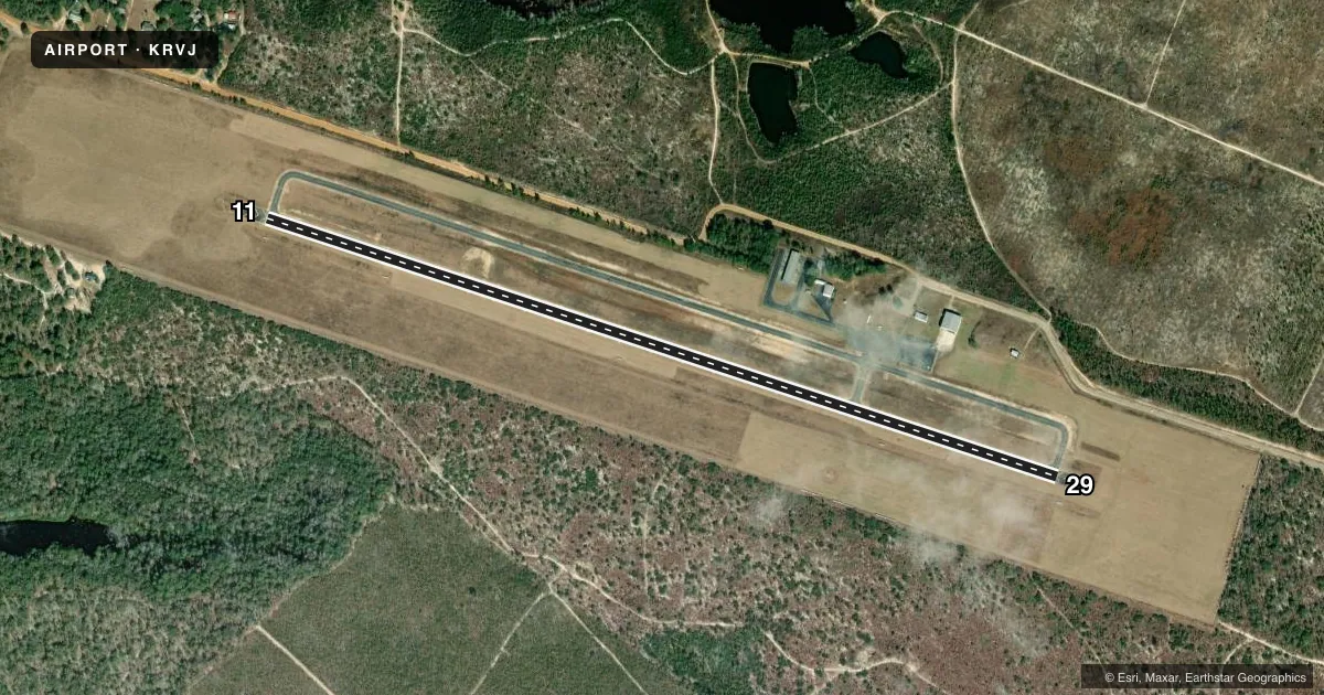
Airport sketch
Runways drawn to scale from FAA survey coordinates, rendered over satellite imagery. Not for navigation.
Approaches & charts
Services on the field
Fuel grades, oxygen, maintenance, ramp storage and lighting — as declared to the FAA by the airport operator.
Fuel & services
- Fuel
- 100LLA
- Oxygen (bottled)
- Not available
- Oxygen (bulk)
- Not available
- Airframe repair
- Not available
- Power plant repair
- Not available
Ramp & ground
- Transient storage
- Tie-down
- Landing fee
- No fee published
- Lighting schedule
- SEE RMK
- Beacon schedule
- SS-SR
- Beacon
- White / Green (civil land)(WG)
- Wind indicator
- Lighted
- Segmented circle
- Yes
Fuel & FBOs
Cheapest 100LL and Jet A on the field and nearby. Always confirm with the FBO before taxi.
Airport notes
Surface conditions, obstructions, local procedures, lighting outages and other notes published with each FAA cycle.
General notes
- FOR CD CTC JACKSONVILLE ARTCC AT 904-845-1592.
Lighting notes
- ACTVT PAPI RYS 11 & 29, MIRL RY 11/29 PRESET LOW INTS DUSK-0230; TO INCR INTS & ACTVT AFTER 0230 - CTAF.
Fuel notes
- 100LLFUEL 24 HR CREDIT CARD SVC AVBL.
Other notes
- MANAGERCHAIR OF AIRPORT AUTHORITY
VFR map & nearby airports
VFR sectional. Tap any ICAO chip to open that airport.
Key facts · KRVJ
Answer card- ICAO
- KRVJ
- Name
- SWINTON SMITH FLD AT REIDSVILLE MUNI
- Location
- REIDSVILLE, GEORGIA
- Elevation
- 195.6 ft MSL
- Traffic pattern altitude
- 1,195.6 ft MSL (1,000 AGL)
- Control tower
- Non-towered (use CTAF)
- Total runways
- 1
- Longest runway
- 11/29 · 5,003 ft
- Published ILS approaches
- 0
- Published frequencies
- 1
- Magnetic variation
- 6°
- Current flight rules
- VFR
- Current wind
- 330° at 3 kt
- Favored runway now
- RWY 29
Swinton Smith Fld at Reidsville Muni (KRVJ) sits in Reidsville, Georgia. Field elevation is 195.6 ft MSL. The airport has one runway, 11/29, which is 5,003 ft of asphalt. There is no control tower. CTAF is 122.9. No ILS approaches are published here.
Pattern altitude is not published. Use the standard 1,000 ft AGL pattern unless local procedures or current Chart Supplement remarks say otherwise. The field has PAPI on runways 11 and 29. The runway lights are medium intensity. They come up at low intensity from dusk to 0230. After 0230, use CTAF to increase intensity and activate the lights.
Reidsville Airport Authority is on the field. It carries 100LL and Jet A. Fuel is available 24 hours with credit card service. For clearance delivery, contact Jacksonville ARTCC at 904-845-1592. This is a non-towered airport, so plan your calls carefully and expect self-announce traffic on CTAF. For any current noise or operational restrictions, check the current FAA Chart Supplement before you go.