METAR & TAF 4J8
4J8 does not publish a METAR.
Showing the nearest reporting station: KVDI (VIDALIA RGNL) · 15.2 NM away. Conditions at 4J8 may differ.
METAR · KVDI
Observed 13:15Z
KVDI 271315Z AUTO 33007KT 10SM CLR 27/26 A2988 RMK AO2
- Wind
- 330° @ 7 kt
- Visibility
- 10 SM
- Temp / Dew
- 27°C / 26°C
- Altimeter
- 29.88 inHg
- Clouds
- CLR
- Density alt
- 1,917 ft
- Ceiling
- Unlimited
- Rules
- VFR
Airport info & contacts
Manager on record, flight service, ARTCC, attendance schedule and pattern altitude — published by the FAA and refreshed every 28 days.
Location
- From city
- 2 NM E
- VFR sectional
- ATLANTA
- ARTCC
- ZJX · JACKSONVILLE
- NOTAM facility
- MCN (NOTAM-D)
Airport manager
- Name
- TJ HUDSON, COUNTY MANAGER
- Phone
- 912-529-3664
- Address
- 1830 MLK DRIVE, SOPERTON GA 30457
Flight service · Hours
- FSS MCN
- MACON1-800-WX-BRIEF
- Attendance
- Unattended
Frequencies
Tap any row to copy the frequency to your clipboard.
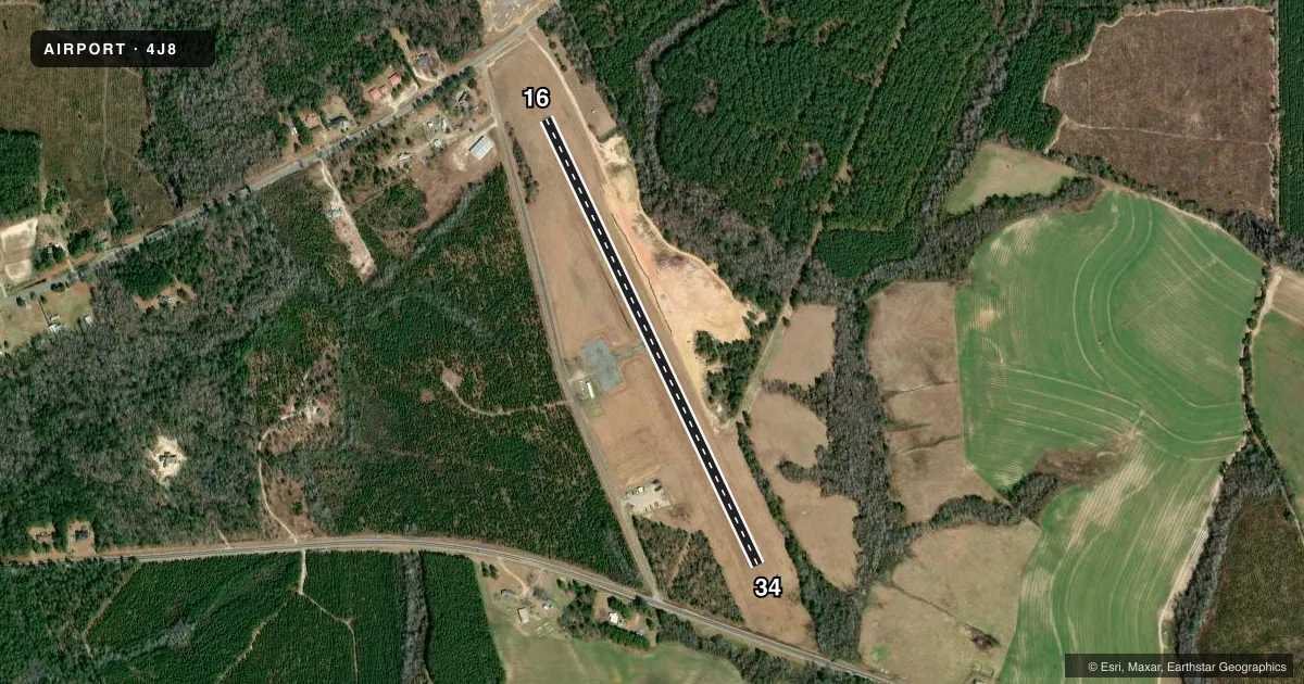
Runways & pattern
Full pagePattern entry · RWY 34
LEFT TRAFFICRunway end performance
| End | TORA | TODA | ASDA | LDA | VGSI | Approach lights | Obstruction |
|---|---|---|---|---|---|---|---|
| 16 | — | — | — | — | — | — | 58', trees, 658' from thr, 169' R of cntrln, slope 7 |
| 34 | — | — | — | — | — | — | 49', trees, 883' from thr, 72' R of cntrln, slope 13 |
Declared distances in feet. TORA = takeoff run available, TODA = takeoff distance, ASDA = accelerate-stop, LDA = landing distance.
Airport sketch
Runways drawn to scale from FAA survey coordinates, rendered over satellite imagery. Not for navigation.
Approaches & charts
Services on the field
Fuel grades, oxygen, maintenance, ramp storage and lighting — as declared to the FAA by the airport operator.
Fuel & services
- Fuel
- Not available
- Oxygen (bottled)
- Not available
- Oxygen (bulk)
- Not available
- Airframe repair
- Not available
- Power plant repair
- Not available
Ramp & ground
- Transient storage
- Tie-down
- Landing fee
- No fee published
- Wind indicator
- Yes
- Segmented circle
- No
Fuel & FBOs
Cheapest 100LL and Jet A on the field and nearby. Always confirm with the FBO before taxi.
Airport notes
Surface conditions, obstructions, local procedures, lighting outages and other notes published with each FAA cycle.
General notes
- FOR CD CTC JACKSONVILLE ARTCC AT 904-845-1592.
Other notes
- VFR ONLY.
- MANAGEREMERGENCY PHONE: 912-529-3222 (TREUTLEN COUNTY SHERIFF).
VFR map & nearby airports
VFR sectional. Tap any ICAO chip to open that airport.
Key facts · 4J8
Answer card- ICAO
- 4J8
- Name
- TREUTLEN COUNTY
- Location
- SOPERTON, GEORGIA
- Elevation
- 345 ft MSL
- Traffic pattern altitude
- 1,345 ft MSL (1,000 AGL)
- Control tower
- Non-towered (use CTAF)
- Total runways
- 1
- Longest runway
- 16/34 · 3,000 ft
- Published ILS approaches
- 0
- Published frequencies
- 1
- Magnetic variation
- 3°
- Current flight rules
- VFR
- Current wind
- 330° at 7 kt
- Favored runway now
- RWY 34
Treutlen County Airport sits in Soperton, Georgia. Field elevation is 345 ft MSL. It has one runway, 16/34, at 3,000 ft of asphalt. This is a non-towered field. CTAF is 122.9.
No ILS approaches are published here. The airport remarks say VFR only. Plan for visual operations only. Pattern altitude is not published in the facts block. Use the current FAA Chart Supplement before you go. For clearance delivery, contact Jacksonville ARTCC at 904-845-1592. The published remarks also list an emergency phone for the Treutlen County Sheriff at 912-529-3222.
There are no on-field FBOs listed in the facts. Contact the airport operator directly before arrival, or call the field on CTAF for current FBO availability. With a 3,000 ft runway, this is a short local strip. Check performance, runway condition and winds before you launch. The runway headings are 16 and 34. Magnetic variation is 3°.