METAR & TAF KDBN
Current METAR
Observed 13:35Z
KDBN 271335Z AUTO 00000KT 9SM CLR 29/27 A2990 RMK AO2 T02880267
- Wind
- 000° @ 0 kt
- Visibility
- 9 SM
- Temp / Dew
- 29°C / 27°C
- Altimeter
- 29.90 inHg
- Clouds
- CLR
- Density alt
- 2,090 ft
- Ceiling
- Unlimited
- Rules
- VFR
Airport info & contacts
Manager on record, flight service, ARTCC, attendance schedule and pattern altitude — published by the FAA and refreshed every 28 days.
Location
- From city
- 3 NM NW
- VFR sectional
- ATLANTA
- ARTCC
- ZTL · ATLANTA
- NOTAM facility
- MCN (NOTAM-D)
Airport manager
- Name
- BRYAN ROGERS, COUNTY ADM
- Phone
- 478-272-4755
- Address
- PO BOX 2011, DUBLIN GA 31040
Flight service · Hours
- FSS MCN
- MACON1-800-WX-BRIEF
- Attendance
- MON-FRI · 0800-1700
Frequencies
Tap any row to copy the frequency to your clipboard.
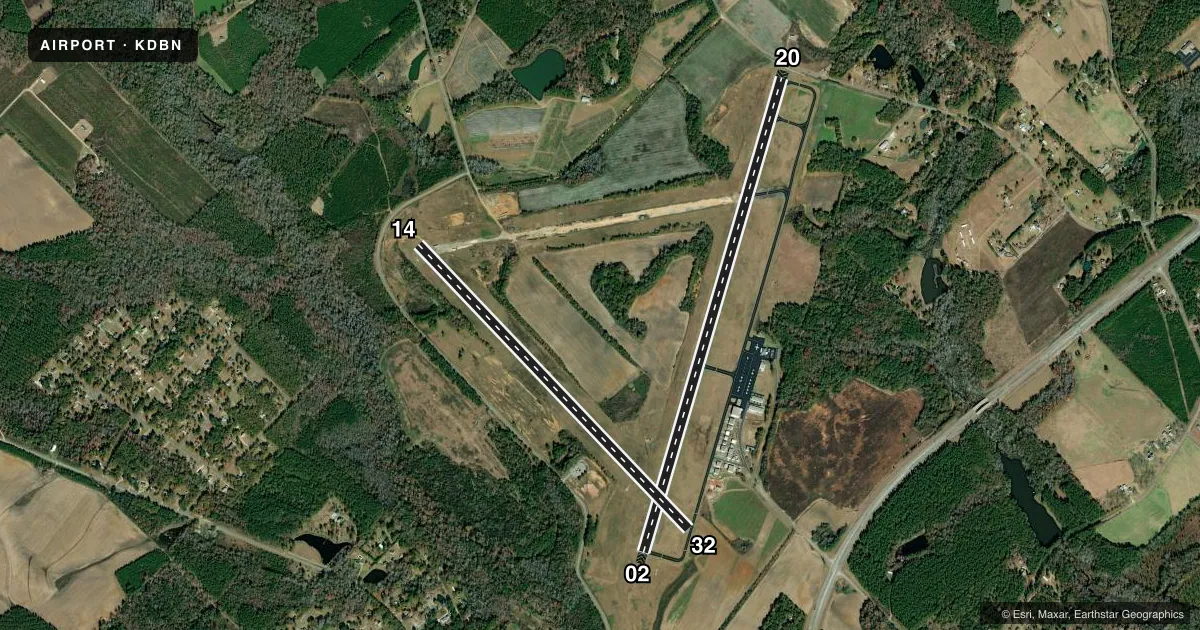
Runways & pattern
Full pagePattern entry · RWY 02
LEFT TRAFFIC| Runway | Heading (°M) | Length | Surface | Traffic |
|---|---|---|---|---|
| 02/20 | 12° / 192° | 6,501 ft | ASPH | Standard L |
| 14/32 | 132° / 312° | 5,171 ft | ASPH | Standard L |
Runway end performance
| End | TORA | TODA | ASDA | LDA | VGSI | Approach lights | Obstruction |
|---|---|---|---|---|---|---|---|
| 02 | 6,300' | 6,300' | 6,300' | 6,300' | PAPI 2-box left(3°) | MALSR | 64', trees, 1419' from thr, 602' R of cntrln, slope 19 |
| 20 | 6,500' | 6,500' | 6,000' | 6,000' | PAPI 2-box left(3°) | — | 15', road, 201' from thr, 36' R of cntrln, slope 0 |
| 14 | 5,171' | 5,171' | 5,171' | 5,171' | — | — | 64', trees, 1445' from thr, 189' R of cntrln, slope 19 |
| 32 | 5,171' | 5,171' | 5,171' | 5,171' | — | — | 98', trees, 1604' from thr, 194' R of cntrln, slope 14 |
Declared distances in feet. TORA = takeoff run available, TODA = takeoff distance, ASDA = accelerate-stop, LDA = landing distance.
Airport sketch
Runways drawn to scale from FAA survey coordinates, rendered over satellite imagery. Not for navigation.
Approaches & charts
ILS · 1
Services on the field
Fuel grades, oxygen, maintenance, ramp storage and lighting — as declared to the FAA by the airport operator.
Fuel & services
- Fuel
- 100LLA+
- Oxygen (bottled)
- Not available
- Oxygen (bulk)
- Not available
- Airframe repair
- Major
- Power plant repair
- Major
- Other services
- INSTR
Ramp & ground
- Transient storage
- Tie-down
- Landing fee
- No fee published
- Customs
- Not available
- Lighting schedule
- SEE RMK
- Beacon schedule
- SS-SR
- Beacon
- White / Green (civil land)(WG)
- Wind indicator
- Yes
- Segmented circle
- Yes
Fuel & FBOs
Cheapest 100LL and Jet A on the field and nearby. Always confirm with the FBO before taxi.
Airport notes
Surface conditions, obstructions, local procedures, lighting outages and other notes published with each FAA cycle.
General notes
- FOR APCH/DEP SVC CTC ATLANTA APCH AT 678-364-6131. WHEN ATLANTA APCH UNAVBL CTC ATLANTA ARTCC AT 770-210-7692.
- FOR CD IF UNA TO CTC ON FSS FREQ, CTC ATLANTA APCH AT 678-364-6132, WHEN ATCT CLSD CTC ATLANTA ARTCC AT 770-210-7692.
Lighting notes
- ACTVT MALSR RWY 02; PAPI RWY 02 & 20 - CTAF. HIRL RWY 02/20 OPER CONT DUSK-2200; AFTER 2200 ACTVT - CTAF.
Fuel notes
- 100LLSELF-SERVICE FUEL AVBL 24 HRS WITH CREDIT CARD.
Approach & departure obstructions
- 20CONTROLLING OBSTRUCTION EXCEEDS A 45 DEGREE SLOPE
Other notes
- 1ARPT PHONE 478-275-0029.
VFR map & nearby airports
VFR sectional. Tap any ICAO chip to open that airport.
Key facts · KDBN
Answer card- ICAO
- KDBN
- Name
- W H 'BUD' BARRON
- Location
- DUBLIN, GEORGIA
- Elevation
- 311 ft MSL
- Traffic pattern altitude
- 1,311 ft MSL (1,000 AGL)
- Control tower
- Non-towered (use CTAF)
- Total runways
- 2
- Longest runway
- 02/20 · 6,501 ft
- Published ILS approaches
- 1
- Published frequencies
- 5
- Magnetic variation
- 4°
- Current flight rules
- VFR
- Current wind
- 000° at 0 kt
- Favored runway now
- –
W H "Bud" Barron Airport is in Dublin, Georgia. Field elevation is 311 ft MSL. The airport has 2 asphalt runways. The longest is runway 02/20 at 6,501 ft. There is no control tower, so plan on CTAF work and standard non-towered procedures.
An ILS is available to runway 02. Pattern altitude is not published in the facts, so use the standard 1,000 ft AGL for light piston operations unless the current Chart Supplement says otherwise. The published remarks matter here. Runway 02 has MALSR lighting. PAPI is available for runways 02 and 20 on CTAF. High intensity runway lights for 02/20 run from dusk to 2200. After 2200, activate the lights on CTAF. Runway 20 also has a published obstruction note. The controlling obstruction exceeds a 45 degree slope. Give that end a close look before you plan your landing or departure.
There are no on-field FBOs listed in the facts. Self-service 100LL is available 24 hours with a credit card. For clearance or approach and departure help, use the Atlanta numbers in the Chart Supplement remarks if Flight Service is not available. The airport phone number is 478-275-0029.