METAR & TAF 51A
51A does not publish a METAR.
Showing the nearest reporting station: KEZM (HEART OF GEORGIA RGNL) · 16.2 NM away. Conditions at 51A may differ.
METAR · KEZM
Observed 12:35Z
KEZM 271235Z AUTO 30003KT 7SM CLR 25/24 A2993 RMK AO2
- Wind
- 300° @ 3 kt
- Visibility
- 7 SM
- Temp / Dew
- 25°C / 24°C
- Altimeter
- 29.93 inHg
- Clouds
- CLR
- Density alt
- 1,522 ft
- Ceiling
- Unlimited
- Rules
- VFR
Airport info & contacts
Manager on record, flight service, ARTCC, attendance schedule and pattern altitude — published by the FAA and refreshed every 28 days.
Location
- From city
- 2 NM E
- VFR sectional
- ATLANTA
- ARTCC
- ZTL · ATLANTA
- NOTAM facility
- MCN (NOTAM-D)
Airport manager
- Name
- SARA MYERS
- Phone
- 478-892-3240
- Address
- P.O. BOX 120, 96 BROAD STREET, HAWKINSVILLE GA 31036
Flight service · Hours
- FSS MCN
- MACON1-800-WX-BRIEF
- Attendance
- Unattended
Frequencies
Tap any row to copy the frequency to your clipboard.
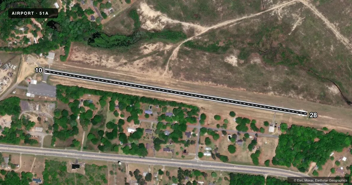
Runways & pattern
Full pagePattern entry · RWY 28
LEFT TRAFFICRunway end performance
| End | TORA | TODA | ASDA | LDA | VGSI | Approach lights | Obstruction |
|---|---|---|---|---|---|---|---|
| 10 | — | — | — | — | — | — | 12', trees, 334' from thr, 134' R of cntrln, slope 11 |
| 28 | — | — | — | — | — | — | 33', trees, 507' from thr, 137' R of cntrln, slope 9 |
Declared distances in feet. TORA = takeoff run available, TODA = takeoff distance, ASDA = accelerate-stop, LDA = landing distance.
Airport sketch
Runways drawn to scale from FAA survey coordinates, rendered over satellite imagery. Not for navigation.
Approaches & charts
Services on the field
Fuel grades, oxygen, maintenance, ramp storage and lighting — as declared to the FAA by the airport operator.
Fuel & services
- Fuel
- Not available
- Oxygen (bottled)
- Not available
- Oxygen (bulk)
- Not available
- Airframe repair
- Not available
- Power plant repair
- Not available
- Other services
- AGRI
Ramp & ground
- Transient storage
- Tie-down
- Landing fee
- No fee published
- Customs
- Not available
- Lighting schedule
- SEE RMK
- Beacon schedule
- SS-SR
- Beacon
- White / Green (civil land)(WG)
- Wind indicator
- Lighted
- Segmented circle
- No
Fuel & FBOs
Cheapest 100LL and Jet A on the field and nearby. Always confirm with the FBO before taxi.
Airport notes
Surface conditions, obstructions, local procedures, lighting outages and other notes published with each FAA cycle.
General notes
- DEER ON & INVOF ARPT.
- FOR CD CTC ATLANTA APCH AT 678-364-6132, WHEN APCH CLSD CTC ATLANTA ARTCC AT 770-210-7692.
Lighting notes
- ARPT BCN LCTD 1000 FT SOUTH ON WATER TWR.
- DUSK-2300. MIRL RY 10/28 PRESET MED INTST DUSK-2300; TO INCR INTST AND ACTVT AFTER 2300 - CTAF.
Other notes
- EXISTED PRIOR TO 1959.
- OWNERAND PULASKI COUNTY.
- MANAGERCITY MANAGER
VFR map & nearby airports
VFR sectional. Tap any ICAO chip to open that airport.
Key facts · 51A
Answer card- ICAO
- 51A
- Name
- HAWKINSVILLE-PULASKI COUNTY
- Location
- HAWKINSVILLE, GEORGIA
- Elevation
- 270 ft MSL
- Traffic pattern altitude
- 1,270 ft MSL (1,000 AGL)
- Control tower
- Non-towered (use CTAF)
- Total runways
- 1
- Longest runway
- 10/28 · 3,000 ft
- Published ILS approaches
- 0
- Published frequencies
- 1
- Magnetic variation
- 2°
- Current flight rules
- VFR
- Current wind
- 300° at 3 kt
- Favored runway now
- RWY 28
Hawkinsville-Pulaski County Airport (51A) sits in Hawkinsville, Georgia. Field elevation is 270 ft MSL. The airport has one runway. Runway 10/28 is 3,000 ft long with an asphalt surface. There is no control tower. CTAF is 122.9. No ILS approaches are published here.
The pattern altitude is not published in the facts. Use the current FAA Chart Supplement before you fly the pattern. The published remarks also matter here. Deer are on and near the airport. The beacon is on a water tower 1,000 ft south of the field. For clearance delivery, contact Atlanta Approach at 678-364-6132. If approach is closed, contact Atlanta ARTCC at 770-210-7692.
Lighting is worth planning around. From dusk to 2300, the medium intensity runway lights on 10/28 are preset. After 2300, use the CTAF to increase intensity and turn the lights on. The airport is city and county owned. The city manager serves as the airport manager. For a first-time arrival, expect a simple non-towered field with wildlife awareness and standard rural airport traffic flow.