METAR & TAF KMCN
Current METAR
Observed 11:53Z
KMCN 271153Z 27005KT 5SM BR CLR 25/25 A2990 RMK AO2 SLP118 T02500250 10261 20250 53011
- Wind
- 270° @ 5 kt
- Visibility
- 5 SM
- Temp / Dew
- 25°C / 25°C
- Altimeter
- 29.90 inHg
- Clouds
- CLR
- Density alt
- 1,664 ft
- Ceiling
- Unlimited
- Rules
- MVFR
Airport info & contacts
Manager on record, flight service, ARTCC, attendance schedule and pattern altitude — published by the FAA and refreshed every 28 days.
Location
- From city
- 9 NM S
- VFR sectional
- ATLANTA
- ARTCC
- ZTL · ATLANTA
- NOTAM facility
- MCN (NOTAM-D)
Airport manager
- Name
- DOUGLAS FAOUR
- Phone
- 478-219-1142
- Address
- 1000 TERMINAL DR, MACON GA 31297
Flight service · Hours
- FSS MCN
- MACON1-800-WX-BRIEF
- Attendance
- 0500-2000
Frequencies
Tap any row to copy the frequency to your clipboard.
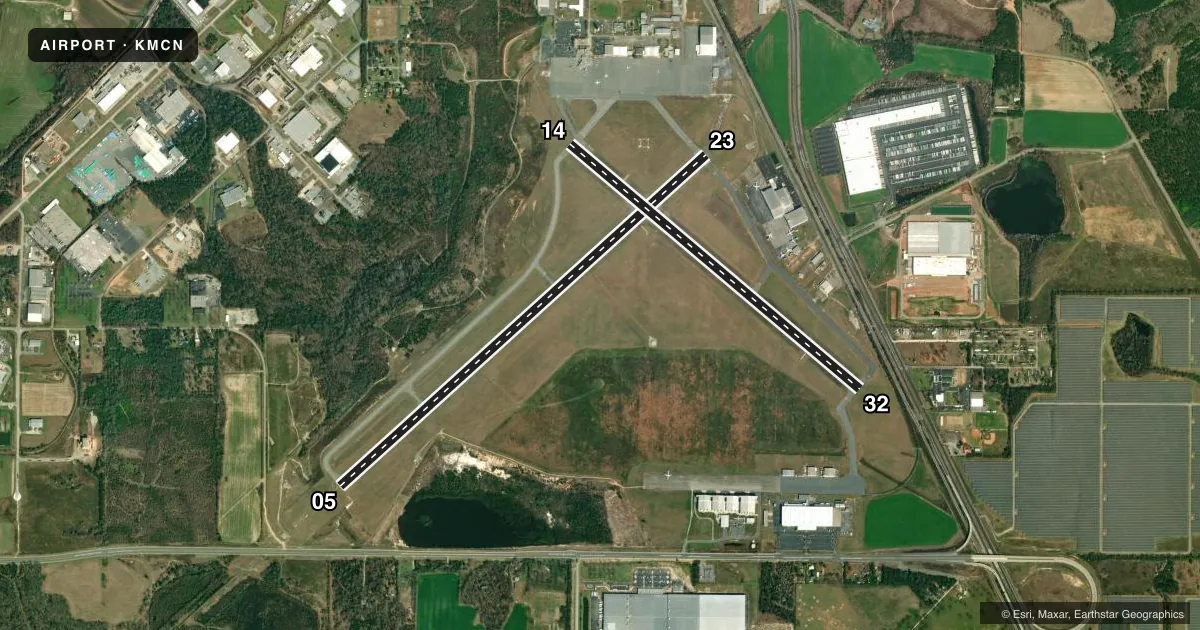
Runways & pattern
Full pagePattern entry · RWY 32
LEFT TRAFFIC| Runway | Heading (°M) | Length | Surface | Traffic |
|---|---|---|---|---|
| 05/23 | 42° / 222° | 6,500 ft | ASPH | 23 R |
| 14/32Favored | 124° / 304° | 5,000 ft | ASPH | 14 R |
Runway end performance
| End | TORA | TODA | ASDA | LDA | VGSI | Approach lights | Obstruction |
|---|---|---|---|---|---|---|---|
| 05 | 6,501' | 6,501' | 6,221' | 6,221' | — | MALSR | 27', trees, 1540' from thr, 450' R of cntrln, slope 50 |
| 23 | 6,501' | 6,501' | 6,426' | 6,426' | PAPI 4-box left(3°) | — | 47', trees, 1140' from thr, 350' R of cntrln, slope 20 |
| 14 | 5,000' | 5,000' | 5,000' | 5,000' | PAPI 4-box left(3°) | — | 43', trees, 1060' from thr, 50' R of cntrln, slope 20 |
| 32 | 5,000' | 5,000' | 5,000' | 5,000' | PAPI 4-box left(3°) | — | 32', rr, 525' from thr, 300' R of cntrln, slope 10 |
Declared distances in feet. TORA = takeoff run available, TODA = takeoff distance, ASDA = accelerate-stop, LDA = landing distance.
Airport sketch
Runways drawn to scale from FAA survey coordinates, rendered over satellite imagery. Not for navigation.
Approaches & charts
ILS · 1
Services on the field
Fuel grades, oxygen, maintenance, ramp storage and lighting — as declared to the FAA by the airport operator.
Fuel & services
- Fuel
- 100LLA
- Oxygen (bottled)
- HIGH/LOW
- Oxygen (bulk)
- Not available
- Airframe repair
- Major
- Power plant repair
- Major
- Other services
- AFRT,AMB,CHTR,INSTR,RNTL,SALES
Ramp & ground
- Transient storage
- Tie-down
- Hangar
- Landing fee
- No fee published
- Customs
- Not available
- Lighting schedule
- SEE RMK
- Beacon schedule
- SS-SR
- Beacon
- White / Green (civil land)(WG)
- Wind indicator
- Lighted
- Segmented circle
- Yes
Fuel & FBOs
Cheapest 100LL and Jet A on the field and nearby. Always confirm with the FBO before taxi.
Airport notes
Surface conditions, obstructions, local procedures, lighting outages and other notes published with each FAA cycle.
General notes
- ROBINS AFB CLASS D AIRSPACE .4 MI SE OF DEP END RY 14. VFR ACFT DEP RY 14 BTN 2000-0800 ARE ADVISED TO CTC ROBINS ATCT 133.22/320.1 PRIOR TO DEP.
- DEER ON & INVOF ARPT.
- PAEW ADJ TO THE MOVEMENT AREAS FROM MARCH 1 TO NOV 1 FOR GRASS CUTTING.
- FOR CD IF UNA TO CTC ON FSS FREQ, CTC ATLANTA APCH AT 678-364-6132, WHEN ATCT CLSD CTC ATLANTA ARTCC AT 770-210-7692.
- NO ACFT WITH WINGSPAN GTR THAN 118 FT MAY TAXI ON TWY C BTN RWY 23 AND RWY 32.
Lighting notes
- ACTVT MALSR RWY 05; REIL RWY 23 & 32; HIRL RWY 05/23; MIRL RWY 14/32 & TWY LGTS - CTAF.
Runway surface & condition
- 05/23PCR VALUE: 755/F/D/X/T
- 14/32PCR VALUE: 570/F/D/X/T
Other notes
- EXISTED PRIOR TO 1959.
- 1FOR SVC AFT HRS HIGHNOTE AVIATION - 478-957-9791.
VFR map & nearby airports
VFR sectional. Tap any ICAO chip to open that airport.
Key facts · KMCN
Answer card- ICAO
- KMCN
- Name
- MIDDLE GEORGIA RGNL
- Location
- MACON, GEORGIA
- Elevation
- 354.2 ft MSL
- Traffic pattern altitude
- 1,354.2 ft MSL (1,000 AGL)
- Control tower
- Towered · 0800-2000
- Total runways
- 2
- Longest runway
- 05/23 · 6,500 ft
- Published ILS approaches
- 1
- Published frequencies
- 12
- Magnetic variation
- 6°
- Current flight rules
- MVFR
- Current wind
- 270° at 5 kt
- Favored runway now
- RWY 32
Middle Georgia Rgnl is in Macon, Georgia. The field elevation is 354.2 ft MSL. It has two asphalt runways. The longest is runway 05/23 at 6,500 ft. The tower is open from 0800 to 2000. When the tower is closed, clearance and traffic coordination move to Atlanta facilities per the Chart Supplement remarks.
Runway 05 has the published ILS approach. Runway lighting is good to know here. MALSR is installed for 05. High intensity lights are on 05/23. Medium intensity lights are on 14/32. Runway end identifier lights are on 23 and 32. Taxiway lights are on the CTAF frequency. Pattern altitude is not published. Use 1,000 ft AGL for light piston traffic unless ATC or the current Chart Supplement says otherwise.
HighNote Aviation is on the field. It carries 100LL and Jet A. For after-hours service, call the FBO directly. Deer are reported on and near the airport. Runway 14 also sits close to Robins Air Force Base Class D airspace, so departures from 14 need extra attention, especially at night. If you are planning a departure on 14 between 2000 and 0800, the published remarks advise contacting Robins Tower before takeoff.