METAR & TAF 48A
Current METAR
Observed 12:35Z
K48A 271235Z AUTO 29004KT 7SM CLR 26/25 A2991 RMK AO2 T02620254
- Wind
- 290° @ 4 kt
- Visibility
- 7 SM
- Temp / Dew
- 26°C / 25°C
- Altimeter
- 29.91 inHg
- Clouds
- CLR
- Density alt
- 1,800 ft
- Ceiling
- Unlimited
- Rules
- VFR
Airport info & contacts
Manager on record, flight service, ARTCC, attendance schedule and pattern altitude — published by the FAA and refreshed every 28 days.
Location
- From city
- 4 NM E
- VFR sectional
- ATLANTA
- ARTCC
- ZTL · ATLANTA
- NOTAM facility
- MCN (NOTAM-D)
Airport manager
- Name
- LISA EISELE
- Phone
- 478-934-6346
- Address
- 112 WEST DYKES STREET, COCHRAN GA 31014
Flight service · Hours
- FSS MCN
- MACON1-800-WX-BRIEF
- Attendance
- MON-SAT · 0800-1200
Frequencies
Tap any row to copy the frequency to your clipboard.
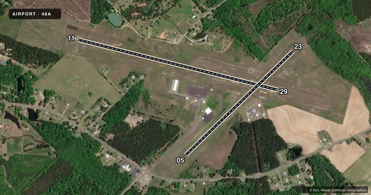
Runways & pattern
Full pagePattern entry · RWY 29
LEFT TRAFFIC| Runway | Heading (°M) | Length | Surface | Traffic |
|---|---|---|---|---|
| 11/29Favored | 101° / 281° | 4,400 ft | ASPH | Standard L |
| 05/23 | 43° / 223° | 3,202 ft | ASPH | Standard L |
Runway end performance
| End | TORA | TODA | ASDA | LDA | VGSI | Approach lights | Obstruction |
|---|---|---|---|---|---|---|---|
| 11 | — | — | — | — | PAPI 2-box left(3.25°) | — | 65', trees, 1585' from thr, 398' R of cntrln, slope 21 |
| 29 | — | — | — | — | PAPI 2-box left(3°) | — | 68', trees, 2363' from thr, 415' R of cntrln, slope 31 |
| 05 | — | — | — | — | — | — | 44', trees, 720' from thr, 88' R of cntrln, slope 11 |
| 23 | 3,202' | 3,202' | 3,202' | 3,062' | — | — | 40', trees, 1143' from thr, 27' R of cntrln, slope 23 |
Declared distances in feet. TORA = takeoff run available, TODA = takeoff distance, ASDA = accelerate-stop, LDA = landing distance.
Airport sketch
Runways drawn to scale from FAA survey coordinates, rendered over satellite imagery. Not for navigation.
Approaches & charts
Services on the field
Fuel grades, oxygen, maintenance, ramp storage and lighting — as declared to the FAA by the airport operator.
Fuel & services
- Fuel
- 100LL
- Oxygen (bottled)
- Not available
- Oxygen (bulk)
- Not available
- Airframe repair
- Minor
- Power plant repair
- Minor
- Other services
- AGRI
Ramp & ground
- Transient storage
- Tie-down
- Landing fee
- No fee published
- Customs
- Not available
- Lighting schedule
- SEE RMK
- Beacon schedule
- SS-SR
- Beacon
- White / Green (civil land)(WG)
- Wind indicator
- Lighted
- Segmented circle
- Yes
Fuel & FBOs
Cheapest 100LL and Jet A on the field and nearby. Always confirm with the FBO before taxi.
Airport notes
Surface conditions, obstructions, local procedures, lighting outages and other notes published with each FAA cycle.
General notes
- NON STD TURNAROUNDS, INADEQUATE SEPARATION RUNWAY 05/23.
- FOR CD CTC ATLANTA APCH AT 678-364-6132, WHEN APCH CLSD CTC ATLANTA ARTCC AT 770-210-7692.
Lighting notes
- MIRL RWY 11/29 PRESET LOW DAWN-0800, DUSK-2100; TO ACTVT OR INCRS INTST - CTAF.
Fuel notes
- 100LL24HR FUEL SELF SERV W/MAJOR CREDIT CARD.
Runway surface & condition
- 05/23RWY 5/23 IS DAYLIGHT USE ONLY.
Other notes
- MANAGERALT PHONE 478-230-7843
- 05/23RWY 05/23 PAVEMENT IN POOR COND.
VFR map & nearby airports
VFR sectional. Tap any ICAO chip to open that airport.
Key facts · 48A
Answer card- ICAO
- 48A
- Name
- COCHRAN
- Location
- COCHRAN, GEORGIA
- Elevation
- 377.4 ft MSL
- Traffic pattern altitude
- 1,377.4 ft MSL (1,000 AGL)
- Control tower
- Non-towered (use CTAF)
- Total runways
- 2
- Longest runway
- 11/29 · 4,400 ft
- Published ILS approaches
- 0
- Published frequencies
- 5
- Magnetic variation
- 3°
- Current flight rules
- VFR
- Current wind
- 290° at 4 kt
- Favored runway now
- RWY 29
Cochran Airport sits in Cochran, Georgia. Field elevation is 377.4 ft MSL. The airport has two asphalt runways. The longest is 11/29 at 4,400 ft. Runway 05/23 is 3,202 ft. There is no control tower. Pattern altitude is not published, so use the standard 1,000 ft AGL for light piston traffic unless the current Chart Supplement says otherwise.
No ILS approaches are published here. CTAF and UNICOM are both 122.8. Atlanta Approach provides approach and departure services on 124.2, 279.6 and 388.2. For clearance delivery, the published remark says to contact Atlanta Approach at 678-364-6132. If Atlanta Approach is closed, contact Atlanta ARTCC at 770-210-7692.
The on-field FBO is Cochran Municipal Airport. It carries 100LL. Twenty-four-hour self-serve fuel is available with major credit cards. Runway 11/29 has medium intensity lights that come up in low setting at dawn and dusk unless you use CTAF to increase them. Runway 05/23 has poor pavement, nonstandard turnarounds, inadequate separation and daylight use only. That makes 11/29 the runway most pilots will want to plan around first.