METAR & TAF KMQW
Current METAR
Observed 13:15Z
KMQW 271315Z AUTO 30005KT 10SM CLR 28/25 A2989 RMK AO2
- Wind
- 300° @ 5 kt
- Visibility
- 10 SM
- Temp / Dew
- 28°C / 25°C
- Altimeter
- 29.89 inHg
- Clouds
- CLR
- Density alt
- 1,848 ft
- Ceiling
- Unlimited
- Rules
- VFR
Airport info & contacts
Manager on record, flight service, ARTCC, attendance schedule and pattern altitude — published by the FAA and refreshed every 28 days.
Location
- From city
- 3 NM NE
- VFR sectional
- ATLANTA
- ARTCC
- ZJX · JACKSONVILLE
- NOTAM facility
- MCN (NOTAM-D)
Airport manager
- Name
- JIMMY RAY
- Phone
- 229-315-1227
- Address
- P.O. BOX 192, MCRAE GA 31055
Flight service · Hours
- FSS MCN
- MACON1-800-WX-BRIEF
- Attendance
- UNATNND
Frequencies
Tap any row to copy the frequency to your clipboard.
Runways & pattern
Full pagePattern entry · RWY 03
LEFT TRAFFICRunway end performance
| End | TORA | TODA | ASDA | LDA | VGSI | Approach lights | Obstruction |
|---|---|---|---|---|---|---|---|
| 03 | — | — | — | — | PAPI 2-box left(3°) | — | 53', trees, 677' from thr, 307' R of cntrln, slope 9 |
| 21 | — | — | — | — | PAPI 2-box left(3°) | — | 66', trees, 926' from thr, 310' R of cntrln, slope 11 |
Declared distances in feet. TORA = takeoff run available, TODA = takeoff distance, ASDA = accelerate-stop, LDA = landing distance.
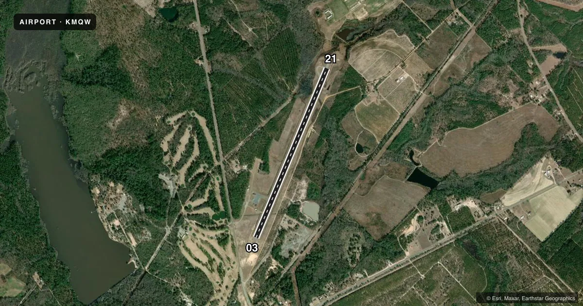
Airport sketch
Runways drawn to scale from FAA survey coordinates, rendered over satellite imagery. Not for navigation.
Approaches & charts
Services on the field
Fuel grades, oxygen, maintenance, ramp storage and lighting — as declared to the FAA by the airport operator.
Fuel & services
- Fuel
- 100LLA+
- Oxygen (bottled)
- Not available
- Oxygen (bulk)
- Not available
- Airframe repair
- Not available
- Power plant repair
- Not available
- Other services
- AGRI,INSTR
Ramp & ground
- Transient storage
- Tie-down
- Landing fee
- No fee published
- Customs
- Not available
- Lighting schedule
- SEE RMK
- Beacon schedule
- SS-SR
- Beacon
- White / Green (civil land)(WG)
- Wind indicator
- Lighted
- Segmented circle
- Yes
Fuel & FBOs
Cheapest 100LL and Jet A on the field and nearby. Always confirm with the FBO before taxi.
Airport notes
Surface conditions, obstructions, local procedures, lighting outages and other notes published with each FAA cycle.
General notes
- FOR CD CTC JACKSONVILLE ARTCC AT 904-845-1592.
- WEATHER DATA SOURCES: AWOS 3PT 120.000 (229) 868-7472
Lighting notes
- ACTVT REIL RWY 21; PAPI RWYS 03 & 21, MIRL RWY 03/21 - CTAF.
VFR map & nearby airports
VFR sectional. Tap any ICAO chip to open that airport.
Key facts · KMQW
Answer card- ICAO
- KMQW
- Name
- TELFAIR-WHEELER
- Location
- MC RAE, GEORGIA
- Elevation
- 202.1 ft MSL
- Traffic pattern altitude
- 1,202.1 ft MSL (1,000 AGL)
- Control tower
- Non-towered (use CTAF)
- Total runways
- 1
- Longest runway
- 03/21 · 5,001 ft
- Published ILS approaches
- 0
- Published frequencies
- 1
- Magnetic variation
- 3°
- Current flight rules
- VFR
- Current wind
- 300° at 5 kt
- Favored runway now
- RWY 03
Telfair-Wheeler Airport sits in McRae, Georgia. Field elevation is 202.1 ft MSL. The airport has one runway. Runway 03/21 is 5,001 ft long and asphalt. There is no control tower. CTAF is 122.9.
No ILS approaches are published here. Pattern altitude is not published, so a standard 1,000 ft AGL pattern is the normal starting point for light piston traffic. The runway lighting is medium intensity. Runway 21 has runway end identifier lights. Runways 03 and 21 have precision approach path indicators. That helps at night or in marginal visibility, but you still need to verify current procedures before you go.
The on-field FBO is Telfair-Wheeler Airport Authority. It carries 100LL and Jet A. Call ahead at (229) 315-1227 for current service details. Weather data is available from AWOS 3PT on 120.000, with phone backup at 229-868-7472. For clearance delivery, Jacksonville ARTCC can be reached at 904-845-1592.
This is a non-towered field with a single runway, so standard CTAF discipline matters. Check the current Chart Supplement for any published noise or curfew restrictions before flying into the field. Also verify any arrival or departure notes before you launch, especially if you are planning a night arrival.