METAR & TAF KAMG
Current METAR
Observed 13:53Z
KAMG 261353Z AUTO 15008KT 10SM FEW016 27/23 A3010 RMK AO2 SLP189 T02670228
- Wind
- 150° @ 8 kt
- Visibility
- 10 SM
- Temp / Dew
- 27°C / 23°C
- Altimeter
- 30.10 inHg
- Clouds
- FEW
- Density alt
- 1,465 ft
- Ceiling
- Unlimited
- Rules
- VFR
Airport info & contacts
Manager on record, flight service, ARTCC, attendance schedule and pattern altitude — published by the FAA and refreshed every 28 days.
Location
- From city
- 3 NM W
- VFR sectional
- JACKSONVILLE
- ARTCC
- ZJX · JACKSONVILLE
- NOTAM facility
- AMG (NOTAM-D)
Airport manager
- Name
- CARL LEGGETT
- Phone
- 912-282-4887
- Address
- P.O. BOX 356, ALMA GA 31510
Flight service · Hours
- FSS MCN
- MACON1-800-WX-BRIEF
- Attendance
- Unattended
Frequencies
Tap any row to copy the frequency to your clipboard.
Runways & pattern
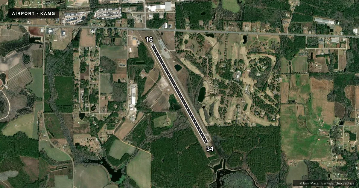
Full pagePattern entry · RWY 16
LEFT TRAFFICRunway end performance
| End | TORA | TODA | ASDA | LDA | VGSI | Approach lights | Obstruction |
|---|---|---|---|---|---|---|---|
| 16 | — | — | — | — | PAPI 2-box left(3°) | — | 24', trees, 676' from thr, 330' R of cntrln, slope 19 |
| 34 | — | — | — | — | PAPI 2-box left(3°) | — | 14', trees, 438' from thr, 0' R of cntrln, slope 17 |
Declared distances in feet. TORA = takeoff run available, TODA = takeoff distance, ASDA = accelerate-stop, LDA = landing distance.
Airport sketch
Runways drawn to scale from FAA survey coordinates, rendered over satellite imagery. Not for navigation.
Approaches & charts
Services on the field
Fuel grades, oxygen, maintenance, ramp storage and lighting — as declared to the FAA by the airport operator.
Fuel & services
- Fuel
- 100LLA+
- Oxygen (bottled)
- Not available
- Oxygen (bulk)
- Not available
- Airframe repair
- Minor
- Power plant repair
- Minor
Ramp & ground
- Transient storage
- Tie-down
- Landing fee
- No fee published
- Customs
- Not available
- Lighting schedule
- SEE RMK
- Beacon schedule
- SS-SR
- Beacon
- White / Green (civil land)(WG)
- Wind indicator
- Lighted
- Segmented circle
- Yes
Fuel & FBOs
Cheapest 100LL and Jet A on the field and nearby. Always confirm with the FBO before taxi.
Airport notes
Surface conditions, obstructions, local procedures, lighting outages and other notes published with each FAA cycle.
General notes
- FOR CD IF UNA TO CTC ON FSS FREQ, CTC JACKSONVILLE ARTCC AT 904-845-1592.
Lighting notes
- ACTVT REIL RWY 16 & 34; PAPI RWY 16 & 34; MIRL RWY 16/34 - CTAF.
Approach & departure obstructions
- 346 FT TREES 155 FT RIGHT, FROM EOR TO 200 FT EOR.
- 34PAPI RWY 34 UNUSBL 5 DEG LEFT OF RCL.
Other notes
- EXISTED PRIOR TO 1959.
VFR map & nearby airports
VFR sectional. Tap any ICAO chip to open that airport.
Key facts · KAMG
Answer card- ICAO
- KAMG
- Name
- BACON COUNTY
- Location
- ALMA, GEORGIA
- Elevation
- 199.8 ft MSL
- Traffic pattern altitude
- 1,199.8 ft MSL (1,000 AGL)
- Control tower
- Non-towered (use CTAF)
- Total runways
- 1
- Longest runway
- 16/34 · 5,000 ft
- Published ILS approaches
- 0
- Published frequencies
- 2
- Magnetic variation
- 6°
- Current flight rules
- VFR
- Current wind
- 150° at 8 kt
- Favored runway now
- RWY 16
Bacon County Airport sits in Alma, Georgia. The field elevation is 199.8 ft MSL. It has one runway, 16/34, at 5,000 ft. There is no control tower. CTAF and UNICOM are both 122.7. No ILS approaches are published here.
For pattern work, the published pattern altitude is not listed. Use the standard 1,000 ft AGL pattern for light piston aircraft unless the current Chart Supplement says otherwise. The on-field FBO is Bacon County Airport. It carries 100LL and Jet A. Call (912) 632-7915 for current services before you go.
A few remarks matter on arrival. Runway end identifier lights and medium intensity runway lights are available for 16 and 34. The lights are controlled on CTAF. PAPI is available for both runway ends. The PAPI for runway 34 is unusable 5 degrees left of centerline. There are also 6-foot trees off the right side near the departure end of runway 34. If you need clearance delivery and cannot raise flight service, Jacksonville ARTCC is listed as the backup contact. This is a non-towered field. Expect self-announce traffic and keep a close ear on 122.7.