METAR & TAF KAYS
Current METAR
Observed 15:55Z
KAYS 271555Z AUTO 34006KT 10SM CLR 33/24 A2990 RMK AO2 T03270238
- Wind
- 340° @ 6 kt
- Visibility
- 10 SM
- Temp / Dew
- 33°C / 24°C
- Altimeter
- 29.90 inHg
- Clouds
- CLR
- Density alt
- 2,360 ft
- Ceiling
- Unlimited
- Rules
- VFR
Airport info & contacts
Manager on record, flight service, ARTCC, attendance schedule and pattern altitude — published by the FAA and refreshed every 28 days.
Location
- From city
- 3 NM NW
- VFR sectional
- JACKSONVILLE
- ARTCC
- ZJX · JACKSONVILLE
- NOTAM facility
- AYS (NOTAM-D)
Airport manager
- Name
- DEE MEADOWS
- Phone
- 912-337-1462
- Address
- 3098 KEEN DRIVE, WAYCROSS GA 31503
Flight service · Hours
- FSS MCN
- MACON1-800-WX-BRIEF
- Attendance
- M-F · 0700-1900
Frequencies
Tap any row to copy the frequency to your clipboard.
Runways & pattern
Full pagePattern entry · RWY 01
LEFT TRAFFIC| Runway | Heading (°M) | Length | Surface | Traffic |
|---|---|---|---|---|
| 01/19Favored | 354° / 174° | 5,992 ft | ASPH | Standard L |
| 05/23 | 37° / 217° | 5,044 ft | ASPH | Standard L |
| 13/31 | 123° / 303° | 3,554 ft | ASPH | Standard L |
Runway end performance
| End | TORA | TODA | ASDA | LDA | VGSI | Approach lights | Obstruction |
|---|---|---|---|---|---|---|---|
| 01 | — | — | — | — | PAPI 2-box left(3°) | — | 70', trees, 1321' from thr, 520' R of cntrln, slope 16 |
| 19 | — | — | — | — | PAPI 2-box left(3°) | MALSR | 97', trees, 1896' from thr, 752' R of cntrln, slope 17 |
| 05 | — | — | — | — | — | — | 80', trees, 1257' from thr, 200' R of cntrln, slope 13 |
| 23 | — | — | — | — | — | — | 69', trees, 1270' from thr, 74' R of cntrln, slope 15 |
| 31 | — | — | — | — | — | — | 53', trees, 1260' from thr, 200' R of cntrln, slope 20 |
Declared distances in feet. TORA = takeoff run available, TODA = takeoff distance, ASDA = accelerate-stop, LDA = landing distance.
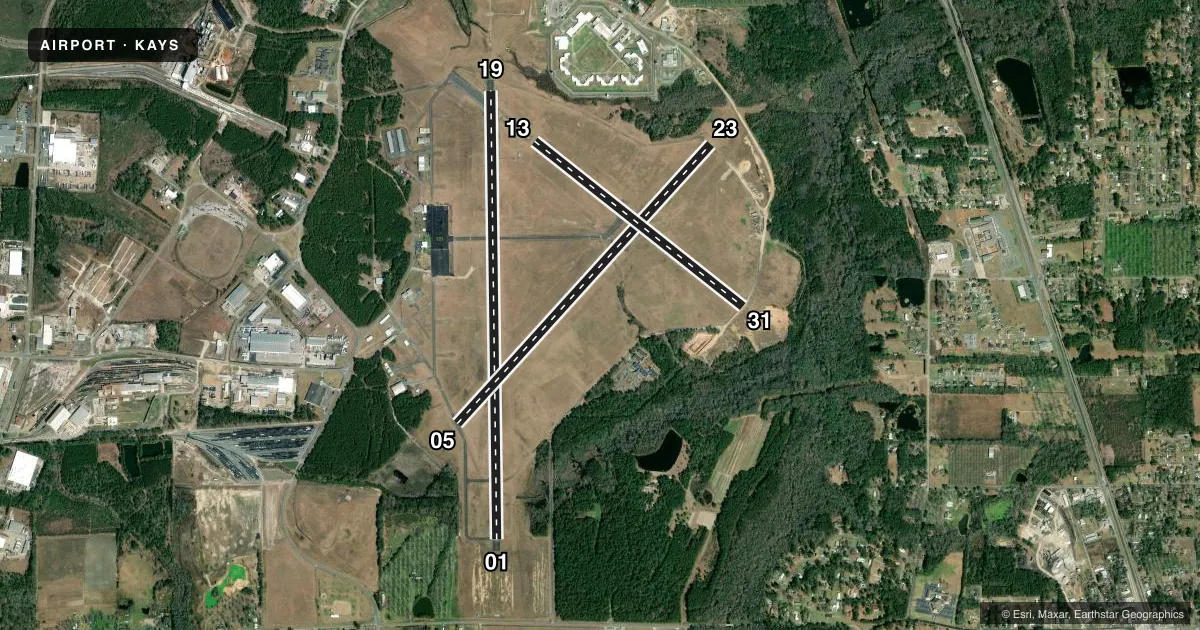
Airport sketch
Runways drawn to scale from FAA survey coordinates, rendered over satellite imagery. Not for navigation.
Approaches & charts
ILS · 1
Services on the field
Fuel grades, oxygen, maintenance, ramp storage and lighting — as declared to the FAA by the airport operator.
Fuel & services
- Fuel
- 100LLA+
- Oxygen (bottled)
- Not available
- Oxygen (bulk)
- Not available
- Airframe repair
- Not available
- Power plant repair
- Not available
Ramp & ground
- Transient storage
- Tie-down
- Hangar
- Landing fee
- No fee published
- Customs
- Not available
- Lighting schedule
- SEE RMK
- Beacon schedule
- SS-SR
- Beacon
- White / Green (civil land)(WG)
- Wind indicator
- Lighted
- Segmented circle
- Yes
Fuel & FBOs
Cheapest 100LL and Jet A on the field and nearby. Always confirm with the FBO before taxi.
Airport notes
Surface conditions, obstructions, local procedures, lighting outages and other notes published with each FAA cycle.
General notes
- 1089 FT TOWER 9.5 NM WEST OF ARPT.
- FOR CD CTC JACKSONVILLE ARTCC AT 904-845-1592.
Lighting notes
- DUSK-2200; AFTER 2200, ACTVT MALSR RWY 19; REIL RWY 19; PAPI RWY 01 & 19; HIRL RWY 01/19 - CTAF.
Fuel notes
- 100LLFOR FUEL AFTER HRS CALL 912-287-4335.
Other notes
- THIS AIRPORT HAS BEEN SURVEYED BY THE NATIONAL GEODETIC SURVEY.
- EXISTED PRIOR TO 1959.
VFR map & nearby airports
VFR sectional. Tap any ICAO chip to open that airport.
Key facts · KAYS
Answer card- ICAO
- KAYS
- Name
- WAYCROSS-WARE COUNTY
- Location
- WAYCROSS, GEORGIA
- Elevation
- 141.3 ft MSL
- Traffic pattern altitude
- 1,141.3 ft MSL (1,000 AGL)
- Control tower
- Non-towered (use CTAF)
- Total runways
- 3
- Longest runway
- 01/19 · 5,992 ft
- Published ILS approaches
- 1
- Published frequencies
- 2
- Magnetic variation
- 5°
- Current flight rules
- VFR
- Current wind
- 340° at 6 kt
- Favored runway now
- RWY 01
Waycross-Ware County Airport sits in Waycross, Georgia. Field elevation is 141.3 ft MSL. It has three asphalt runways. The longest is runway 01/19 at 5,992 ft. There is no control tower. CTAF and UNICOM are both 122.8. One ILS approach is published for runway 19. Pattern altitude is not published, so plan on the standard 1,000 ft AGL for light piston operations unless the current Chart Supplement says otherwise.
The on-field FBO is Ware County Airport. It carries 100LL and Jet A with Prist. If you need fuel after hours, the published remarks give a phone number to call. Lighting is on from dusk to 2200. After 2200, runway 19 lighting can be activated by radio on CTAF. That includes the MALSR, REIL, PAPI and HIRL on runway 19. The airport also has PAPI and HIRL on runway 01. Clearance delivery is handled through Jacksonville ARTCC.
For a first-time arrival, the main things to plan for are the non-towered pattern. Plan for the published lighting procedure. The ILS to runway 19 is also a key item. There is also a 1,089 ft tower about 9.5 NM west of the field. Check the current Chart Supplement for any additional local procedures before you go.