METAR & TAF 4J1
4J1 does not publish a METAR.
Showing the nearest reporting station: KJES (JESUP-WAYNE COUNTY) · 20.9 NM away. Conditions at 4J1 may differ.
METAR · KJES
Observed 13:30Z
KJES 231330Z AUTO 28006KT 10SM BKN016 OVC023 28/25 A3010 RMK AO2
- Wind
- 280° @ 6 kt
- Visibility
- 10 SM
- Temp / Dew
- 28°C / 25°C
- Altimeter
- 30.10 inHg
- Clouds
- OVC
- Density alt
- 1,442 ft
- Ceiling
- 1,600 ft AGL
- Rules
- MVFR
Airport info & contacts
Manager on record, flight service, ARTCC, attendance schedule and pattern altitude — published by the FAA and refreshed every 28 days.
Location
- From city
- 4 NM E
- VFR sectional
- JACKSONVILLE
- ARTCC
- ZJX · JACKSONVILLE
- NOTAM facility
- MCN (NOTAM-D)
Airport manager
- Name
- JOEY CASON
- Phone
- (912) 462-5256
- Address
- 33 ALLEN RD, PO BOX 792, NAHUNTA GA 31553
Flight service · Hours
- FSS MCN
- MACON1-800-WX-BRIEF
- Attendance
- Unattended
Frequencies
Tap any row to copy the frequency to your clipboard.
Runways & pattern
Full pagePattern entry · RWY 01
LEFT TRAFFICRunway end performance
| End | TORA | TODA | ASDA | LDA | VGSI | Approach lights | Obstruction |
|---|---|---|---|---|---|---|---|
| 01 | — | — | — | — | PAPI 2-box left(3°) | — | 20', trees, 201' from thr, 240' R of cntrln, slope 0 |
| 19 | — | — | — | — | PAPI 2-box left(3°) | — | 86', trees, 1060' from thr, 355' R of cntrln, slope 10 |
Declared distances in feet. TORA = takeoff run available, TODA = takeoff distance, ASDA = accelerate-stop, LDA = landing distance.
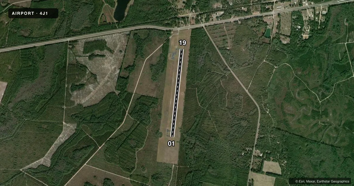
Airport sketch
Runways drawn to scale from FAA survey coordinates, rendered over satellite imagery. Not for navigation.
Approaches & charts
Services on the field
Fuel grades, oxygen, maintenance, ramp storage and lighting — as declared to the FAA by the airport operator.
Fuel & services
- Fuel
- Not available
- Oxygen (bottled)
- Not available
- Oxygen (bulk)
- Not available
- Airframe repair
- Not available
- Power plant repair
- Not available
Ramp & ground
- Transient storage
- Tie-down
- Landing fee
- No fee published
- Customs
- Not available
- Lighting schedule
- SEE RMK
- Beacon schedule
- SS-SR
- Beacon
- White / Green (civil land)(WG)
- Wind indicator
- Lighted
- Segmented circle
- Yes
Fuel & FBOs
Cheapest 100LL and Jet A on the field and nearby. Always confirm with the FBO before taxi.
Airport notes
Surface conditions, obstructions, local procedures, lighting outages and other notes published with each FAA cycle.
General notes
- FOR CD CTC JACKSONVILLE ARTCC AT 904-845-1592.
Lighting notes
- ACTVT PAPI RWY 01 & 19; MIRL RWY 01/19 - CTAF.
VFR map & nearby airports
VFR sectional. Tap any ICAO chip to open that airport.
Key facts · 4J1
Answer card- ICAO
- 4J1
- Name
- BRANTLEY COUNTY
- Location
- NAHUNTA, GEORGIA
- Elevation
- 84.7 ft MSL
- Traffic pattern altitude
- 1,084.7 ft MSL (1,000 AGL)
- Control tower
- Non-towered (use CTAF)
- Total runways
- 1
- Longest runway
- 01/19 · 4,000 ft
- Published ILS approaches
- 0
- Published frequencies
- 1
- Magnetic variation
- 6°
- Current flight rules
- MVFR
- Current wind
- 280° at 6 kt
- Favored runway now
- RWY 01
Brantley County Airport (4J1) sits in Nahunta, Georgia. Field elevation is 84.7 ft MSL. The airport has one runway, 01/19, at 4,000 ft asphalt. There is no control tower. CTAF is 122.9. No ILS approaches are published here.
Pattern altitude is not published. Use the standard 1,000 ft AGL pattern for light piston operations unless the current Chart Supplement says otherwise. The published runway headings are 06° and 186° magnetic. That matters when you brief the wind and your entry.
Lighting is pilot-controlled on CTAF. PAPI is published for runways 01 and 19. For clearance delivery, contact Jacksonville ARTCC at 904-845-1592. There are no on-field FBOs listed in the facts. Plan ahead and confirm services with the airport operator or by calling the field directly before arrival. This is a small, non-towered airport with a single runway. Keep your radio work tight and verify the current Chart Supplement for any local notes before you go.