METAR & TAF 3J6
3J6 does not publish a METAR.
Showing the nearest reporting station: KJAX (JACKSONVILLE INTL) · 25.3 NM away. Conditions at 3J6 may differ.
METAR · KJAX
Observed 15:56Z
KJAX 271556Z 27004KT 10SM FEW030 SCT130 BKN250 32/25 A2988 RMK AO2 SLP118 T03220250 $
- Wind
- 270° @ 4 kt
- Visibility
- 10 SM
- Temp / Dew
- 32°C / 25°C
- Altimeter
- 29.88 inHg
- Clouds
- BKN
- Density alt
- 2,174 ft
- Ceiling
- 25,000 ft AGL
- Rules
- VFR
Airport info & contacts
Manager on record, flight service, ARTCC, attendance schedule and pattern altitude — published by the FAA and refreshed every 28 days.
Location
- From city
- 3 NM SW
- VFR sectional
- JACKSONVILLE
- ARTCC
- ZJX · JACKSONVILLE
- NOTAM facility
- MCN (NOTAM-D)
Airport manager
- Name
- BECKY HARDEN
- Phone
- 912-496-2549
- Address
- 68 KINSLAND DR., STE B, FOLKSTON GA 31537
Flight service · Hours
- FSS MCN
- MACON1-800-WX-BRIEF
- Attendance
- Unattended
Frequencies
Tap any row to copy the frequency to your clipboard.
Runways & pattern
Full pagePattern entry · RWY 19
LEFT TRAFFICRunway end performance
| End | TORA | TODA | ASDA | LDA | VGSI | Approach lights | Obstruction |
|---|---|---|---|---|---|---|---|
| 01 | — | — | — | — | — | — | 42', trees, 201' from thr, 123' R of cntrln, slope 0 |
| 19 | — | — | — | — | — | — | 34', trees, 574' from thr, 108' R of cntrln, slope 11 |
Declared distances in feet. TORA = takeoff run available, TODA = takeoff distance, ASDA = accelerate-stop, LDA = landing distance.
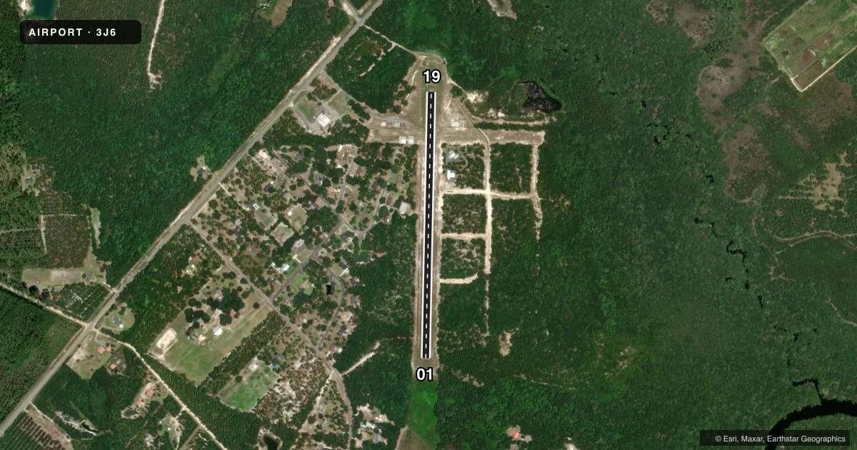
Airport sketch
Runways drawn to scale from FAA survey coordinates, rendered over satellite imagery. Not for navigation.
Approaches & charts
Services on the field
Fuel grades, oxygen, maintenance, ramp storage and lighting — as declared to the FAA by the airport operator.
Fuel & services
- Fuel
- Not available
- Oxygen (bottled)
- Not available
- Oxygen (bulk)
- Not available
- Airframe repair
- Not available
- Power plant repair
- Not available
Ramp & ground
- Transient storage
- Tie-down
- Landing fee
- No fee published
- Customs
- Not available
- Lighting schedule
- SEE RMK
- Beacon schedule
- SS-SR
- Beacon
- White / Green (civil land)(WG)
- Wind indicator
- Lighted
- Segmented circle
- Yes
Fuel & FBOs
Cheapest 100LL and Jet A on the field and nearby. Always confirm with the FBO before taxi.
Airport notes
Surface conditions, obstructions, local procedures, lighting outages and other notes published with each FAA cycle.
General notes
- LGTD 272 FT AGL TOWER 1000 FT WEST.
- FOR CD CTC JACKSONVILLE APCH AT 904-741-0284.
Lighting notes
- MIRL RWY 01/19 PRESET LOW INTST DUSK-2030; AFT 2030 ACTVT - CTAF.
VFR map & nearby airports
VFR sectional. Tap any ICAO chip to open that airport.
Key facts · 3J6
Answer card- ICAO
- 3J6
- Name
- DAVIS FLD
- Location
- FOLKSTON, GEORGIA
- Elevation
- 68 ft MSL
- Traffic pattern altitude
- 1,068 ft MSL (1,000 AGL)
- Control tower
- Non-towered (use CTAF)
- Total runways
- 1
- Longest runway
- 01/19 · 2,500 ft
- Published ILS approaches
- 0
- Published frequencies
- 1
- Magnetic variation
- 3°
- Current flight rules
- VFR
- Current wind
- 270° at 4 kt
- Favored runway now
- RWY 19
Davis Fld sits in Folkston, Georgia. The field elevation is 68 ft MSL. It has one runway. Runway 01/19 is 2,500 ft of asphalt. There is no control tower. CTAF is 122.9.
No ILS approaches are published here. Pattern altitude is not published, so use the standard 1,000 ft AGL for light piston traffic unless the current FAA Chart Supplement says otherwise. The airport is low and flat. That keeps terrain simple. It also means you should stay sharp on pattern discipline and local traffic flow.
Published remarks note that the medium intensity runway lights on 01/19 sit at low intensity from dusk to 2030. After 2030, they are activated by CTAF. Clearance delivery goes through Jacksonville Approach at 904-741-0284. There is also a lighted tower 1,000 ft west of the field that stands 272 ft AGL, so keep that in mind on arrival and departure.
No on-field FBOs are listed. Contact the airport operator directly before arrival if you need fuel or ramp details. For any noise or local operating restrictions, check the current FAA Chart Supplement before you fly in.