METAR & TAF KFHB
Current METAR
Observed 13:35Z
KFHB 271335Z AUTO 32009KT 10SM CLR 29/24 A2989 RMK AO2
- Wind
- 320° @ 9 kt
- Visibility
- 10 SM
- Temp / Dew
- 29°C / 24°C
- Altimeter
- 29.89 inHg
- Clouds
- CLR
- Density alt
- 1,737 ft
- Ceiling
- Unlimited
- Rules
- VFR
Airport info & contacts
Manager on record, flight service, ARTCC, attendance schedule and pattern altitude — published by the FAA and refreshed every 28 days.
Location
- From city
- 3 NM S
- VFR sectional
- JACKSONVILLE
- ARTCC
- ZJX · JACKSONVILLE
- NOTAM facility
- GNV (NOTAM-D)
Airport manager
- Name
- NATHAN COYLE
- Phone
- 904-310-3436
- Address
- 700 AIRPORT ROAD, FERNANDINA BEACH FL 32034
Flight service · Hours
- FSS GNV
- GAINESVILLE1-800-WX-BRIEF
- Attendance
- 0700-1900
Frequencies
Tap any row to copy the frequency to your clipboard.
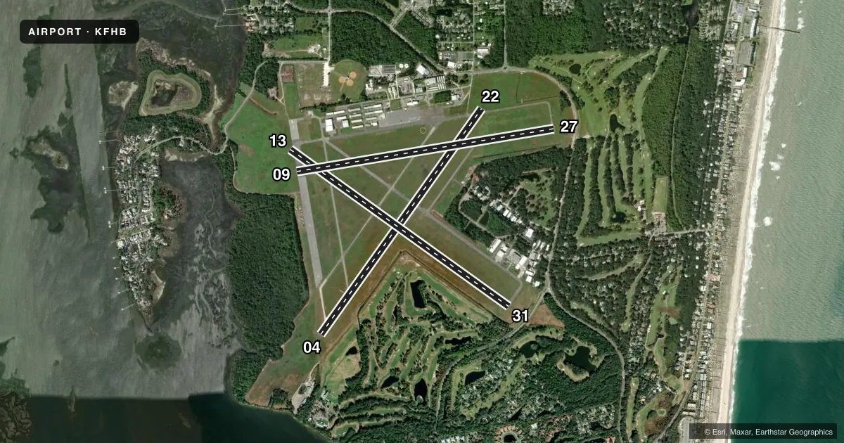
Runways & pattern
Full pagePattern entry · RWY 31
LEFT TRAFFIC| Runway | Heading (°M) | Length | Surface | Traffic |
|---|---|---|---|---|
| 04/22 | 31° / 211° | 5,301 ft | ASPH | Standard L |
| 13/31Favored | 121° / 301° | 5,152 ft | ASPH | Standard L |
| 09/27 | 76° / 256° | 5,000 ft | CONC | Standard L |
Runway end performance
| End | TORA | TODA | ASDA | LDA | VGSI | Approach lights | Obstruction |
|---|---|---|---|---|---|---|---|
| 04 | — | — | — | — | PAPI 4-box left(3°) | — | 35', trees, 1445' from thr, 70' R of cntrln, slope 35 |
| 22 | — | — | — | — | PAPI 4-box left(3°) | — | 45', trees, 1100' from thr, 35' R of cntrln, slope 20 |
| 13 | — | — | — | — | PAPI 2-box left(3°) | — | 44', tree, 2045' from thr, 50' R of cntrln, slope 42 |
| 31 | — | — | — | — | — | — | 45', trees, 675' from thr, 105' R of cntrln, slope 10 |
| 09 | — | — | — | — | PAPI 4-box left(3°) | — | 49', tree, 1210' from thr, 210' R of cntrln, slope 21 |
| 27 | — | — | — | — | PAPI 4-box left(3°) | — | 15', road, 370' from thr, 250' R of cntrln, slope 11 |
Declared distances in feet. TORA = takeoff run available, TODA = takeoff distance, ASDA = accelerate-stop, LDA = landing distance.
Airport sketch
Runways drawn to scale from FAA survey coordinates, rendered over satellite imagery. Not for navigation.
Approaches & charts
Services on the field
Fuel grades, oxygen, maintenance, ramp storage and lighting — as declared to the FAA by the airport operator.
Fuel & services
- Fuel
- 100LLA
- Oxygen (bottled)
- Not available
- Oxygen (bulk)
- Not available
- Airframe repair
- Major
- Power plant repair
- Major
- Other services
- AVNCS,INSTR,PAJA,RNTL
Ramp & ground
- Transient storage
- Tie-down
- Hangar
- Landing fee
- No fee published
- Customs
- Not available
- Lighting schedule
- SEE RMK
- Beacon schedule
- SS-SR
- Beacon
- White / Green (civil land)(WG)
- Wind indicator
- Lighted
- Segmented circle
- Yes
Fuel & FBOs
Cheapest 100LL and Jet A on the field and nearby. Always confirm with the FBO before taxi.
Airport notes
Surface conditions, obstructions, local procedures, lighting outages and other notes published with each FAA cycle.
General notes
- BIRDS ON & INVOF ARPT.
- CAUTION: ACFT ON RWY 31 NOT VSBL TO ACFT ON RWY 22 OR RWY 27.
- FOR CD CTC JACKSONVILLE APCH AT 904-741-0284.
- NOISE ABATEMENT PROC IN EFCT - 904-310-3436.
- PRCHT OPS DLY NW CORNER OF FLD. AVOID OVERFLYING ARPT DURG PRCHT OPS.
- DRG CALM WINDS USE RWY 22.
- 24 HR PPR FOR ACFT EQUIPPED WITH WEATHER MODIFICATION OR GEOENGINEERING EQPT 904-310-3436.
Lighting notes
- ACTVT REIL RWY 04 & 13; PAPI RWY 04, 09, 13, 22, 27; MIRL RWY 04/22, 09/27 & 13/31 - CTAF.
Approach & departure obstructions
- 22RWY 22 APCH RATIO 34:1 TO DSPLCD THLD.
- 27RWY 27 APCH RATIO 25:1 AT DSPLCD THLD.
- 31RWY 31 APCH RATIO 28:1 AT DSPLCD THLD.
Other notes
- VFR OPNS ONLY.
VFR map & nearby airports
VFR sectional. Tap any ICAO chip to open that airport.
Key facts · KFHB
Answer card- ICAO
- KFHB
- Name
- FERNANDINA BEACH MUNI
- Location
- FERNANDINA BEACH, FLORIDA
- Elevation
- 15.7 ft MSL
- Traffic pattern altitude
- 1,015.7 ft MSL (1,000 AGL)
- Control tower
- Non-towered (use CTAF)
- Total runways
- 3
- Longest runway
- 04/22 · 5,301 ft
- Published ILS approaches
- 0
- Published frequencies
- 4
- Magnetic variation
- 5°
- Current flight rules
- VFR
- Current wind
- 320° at 9 kt
- Favored runway now
- RWY 31
Fernandina Beach Muni (KFHB) sits in Fernandina Beach, Florida. The field elevation is 15.7 ft MSL. It has three runways. The longest is runway 04/22 at 5,301 ft. The airport is not towered. CTAF and UNICOM are both 122.7. Jacksonville Approach handles approach and departure work on 127.0 and 292.15.
No ILS approaches are published here. Pattern altitude is not published. Use the standard 1,000 ft AGL for light piston traffic unless the current FAA Chart Supplement says otherwise. Bent Wing Flight Services is on the field. They carry 100LL, Jet A and Jet A Prist. If you need clearance delivery, Jacksonville Approach lists 904-741-0284 in the remarks.
This is a VFR-only field. Noise abatement procedures are in effect. Parachute operations run daily at the northwest corner of the airport, so stay alert and avoid overflying the field during jump activity. Birds are also reported on and near the airport. Runway 22 has an obstacle note on the approach. Runways 27 and 31 also have published obstacle notes. During calm winds, runway 22 is the published choice. Runway lighting is pilot-controlled by CTAF.