METAR & TAF KHEG
Current METAR
Observed 17:15Z
KHEG 271715Z AUTO 31007KT 10SM BKN041 33/23 A2990 RMK AO2 TSNO
- Wind
- 310° @ 7 kt
- Visibility
- 10 SM
- Temp / Dew
- 33°C / 23°C
- Altimeter
- 29.90 inHg
- Clouds
- BKN
- Density alt
- 2,291 ft
- Ceiling
- 4,100 ft AGL
- Rules
- VFR
Airport info & contacts
Manager on record, flight service, ARTCC, attendance schedule and pattern altitude — published by the FAA and refreshed every 28 days.
Location
- From city
- 8 NM SW
- VFR sectional
- JACKSONVILLE
- ARTCC
- ZJX · JACKSONVILLE
- NOTAM facility
- GNV (NOTAM-D)
Airport manager
- Name
- ROLF RIECHMANN
- Phone
- 904-783-2805
- Address
- 9300 NORMANDY BLVD., SUITE 4, JACKSONVILLE FL 32221-5522
Flight service · Hours
- FSS GNV
- GAINESVILLE1-800-WX-BRIEF
- Attendance
- MON-FRI · 0630-1930
- SAT-SUN · 0700-1700
Frequencies
Tap any row to copy the frequency to your clipboard.
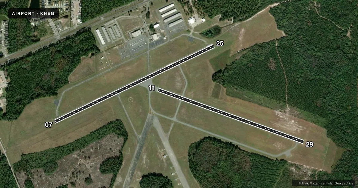
Runways & pattern
Full pagePattern entry · RWY 29
LEFT TRAFFIC| Runway | Heading (°M) | Length | Surface | Traffic |
|---|---|---|---|---|
| 07/25 | 59° / 239° | 4,001 ft | ASPH | Standard L |
| 11/29Favored | 104° / 284° | 3,500 ft | ASPH | Standard L |
Runway end performance
| End | TORA | TODA | ASDA | LDA | VGSI | Approach lights | Obstruction |
|---|---|---|---|---|---|---|---|
| 07 | — | — | — | — | PAPI 2-box left(3°) | — | 50', tree, 1395' from thr, 210' R of cntrln, slope 24 |
| 25 | — | — | — | — | PAPI 2-box left(3°) | — | 60', trees, 2215' from thr, 50' R of cntrln, slope 34 |
| 11 | — | — | — | — | PAPI 2-box left(3°) | — | 76', trees, 2235' from thr, 0' R of cntrln, slope 27 |
| 29 | — | — | — | — | PAPI 2-box left(3°) | — | 50', trees, 1035' from thr, 65' R of cntrln, slope 20 |
Declared distances in feet. TORA = takeoff run available, TODA = takeoff distance, ASDA = accelerate-stop, LDA = landing distance.
Airport sketch
Runways drawn to scale from FAA survey coordinates, rendered over satellite imagery. Not for navigation.
Approaches & charts
Services on the field
Fuel grades, oxygen, maintenance, ramp storage and lighting — as declared to the FAA by the airport operator.
Fuel & services
- Fuel
- 100LLA
- Oxygen (bottled)
- Not available
- Oxygen (bulk)
- Not available
- Airframe repair
- Major
- Power plant repair
- Major
- Other services
- AVNCS,CHTR,GLD,INSTR,PAJA,RNTL,SALES,TOW
Ramp & ground
- Transient storage
- Tie-down
- Hangar
- Landing fee
- No fee published
- Customs
- Not available
- Lighting schedule
- SEE RMK
- Beacon schedule
- SS-SR
- Beacon
- White / Green (civil land)(WG)
- Wind indicator
- Lighted
Fuel & FBOs
Cheapest 100LL and Jet A on the field and nearby. Always confirm with the FBO before taxi.
Airport notes
Surface conditions, obstructions, local procedures, lighting outages and other notes published with each FAA cycle.
General notes
- ULTRALIGHT & GLIDER ACTIVITY ON & INVOF ARPT.
- GCO AVBL ON FREQ 121.725 THRU JACKSONVILLE ARTCC CD AND GAINESVILLE FSS.
- FOR CD IF UNA VIA GCO CTC JACKSONVILLE ARTCC AT 904-741-0284.
- 24-HOUR PPR FOR ACFT EQUIPPED WITH WEATHER MODIFICATION OR GEOENGINEERING EQPT 904-741-2020.
Lighting notes
- ACTVT MIRL RWY 07/25 & 11/29 - CTAF.
Other notes
- VFR OPERATIONS ONLY.
- OWNER904-741-2040.
- MANAGERFBO (904) 783-2805.
VFR map & nearby airports
VFR sectional. Tap any ICAO chip to open that airport.
Key facts · KHEG
Answer card- ICAO
- KHEG
- Name
- HERLONG RECREATIONAL
- Location
- JACKSONVILLE, FLORIDA
- Elevation
- 85.9 ft MSL
- Traffic pattern altitude
- 1,085.9 ft MSL (1,000 AGL)
- Control tower
- Non-towered (use CTAF)
- Total runways
- 2
- Longest runway
- 07/25 · 4,001 ft
- Published ILS approaches
- 0
- Published frequencies
- 5
- Magnetic variation
- 6°
- Current flight rules
- VFR
- Current wind
- 310° at 7 kt
- Favored runway now
- RWY 29
Herlong Recreational Airport sits in Jacksonville, Florida. Field elevation is 85.9 ft MSL. The airport has two asphalt runways. The longest is 4,001 ft on runway 07/25. Runway 11/29 is 3,500 ft. There is no control tower, so expect CTAF self-announce traffic. Pattern altitude is not published. Use 1,000 ft AGL for light piston operations unless the current Chart Supplement says otherwise.
No ILS approaches are published here. This is a VFR-only field, so plan accordingly. First Coast Flight Center is on the field. It carries 100LL and Jet A. The FBO phone number is (904) 783-2805. Medium intensity runway lights are available on both runways. They activate on the common traffic advisory frequency.
A few operational items matter here. Ultralight and glider activity is published on and near the airport. That means extra scanning is smart in the pattern and on final. Ground communications outlet service is available on 121.725 through Jacksonville ARTCC clearance delivery and Gainesville Flight Service Station. If you need clearance delivery and cannot use the ground communications outlet, call Jacksonville ARTCC directly. Check the current FAA Chart Supplement for any updated procedures before flying in.