METAR & TAF 01J
01J does not publish a METAR.
Showing the nearest reporting station: KJAX (JACKSONVILLE INTL) · 16.1 NM away. Conditions at 01J may differ.
METAR · KJAX
Observed 14:56Z
KJAX 271456Z VRB03KT 10SM FEW040 FEW110 BKN250 32/25 A2987 RMK AO2 SLP114 T03170250 55004 $
- Wind
- VAR @ 3 kt
- Visibility
- 10 SM
- Temp / Dew
- 32°C / 25°C
- Altimeter
- 29.87 inHg
- Clouds
- BKN
- Density alt
- 2,175 ft
- Ceiling
- 25,000 ft AGL
- Rules
- VFR
Airport info & contacts
Manager on record, flight service, ARTCC, attendance schedule and pattern altitude — published by the FAA and refreshed every 28 days.
Location
- From city
- 1 NM E
- VFR sectional
- JACKSONVILLE
- ARTCC
- ZJX · JACKSONVILLE
- NOTAM facility
- GNV (NOTAM-D)
Airport manager
- Name
- MICHAEL SWAIN
- Phone
- 904-675-9120
- Address
- 37792 EASTWOOD RD, HILLIARD FL 32406
Flight service · Hours
- FSS GNV
- GAINESVILLE1-800-WX-BRIEF
- Attendance
- Unattended
Frequencies
Tap any row to copy the frequency to your clipboard.
Runways & pattern
Full pagePattern entry · RWY 36
LEFT TRAFFICRunway end performance
| End | TORA | TODA | ASDA | LDA | VGSI | Approach lights | Obstruction |
|---|---|---|---|---|---|---|---|
| 18 | — | — | — | — | PAPI 2-box right(3°) | — | 7', fence, 32' from thr, 0' R of cntrln, slope 4 |
| 36 | — | — | — | — | PAPI 2-box left(3°) | — | 51', trees, 280' from thr, 90' R of cntrln, slope 5 |
Declared distances in feet. TORA = takeoff run available, TODA = takeoff distance, ASDA = accelerate-stop, LDA = landing distance.
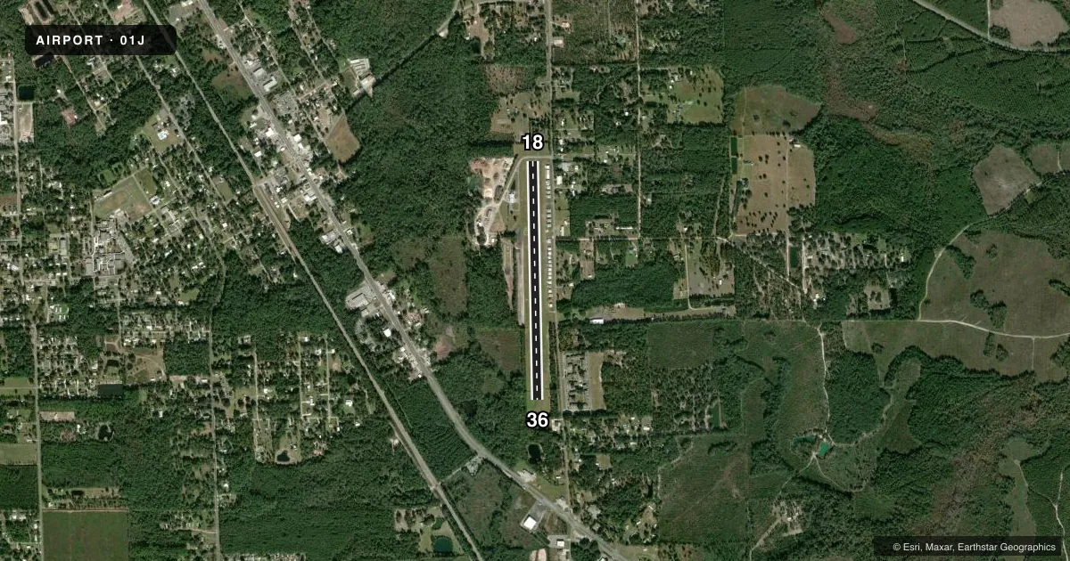
Airport sketch
Runways drawn to scale from FAA survey coordinates, rendered over satellite imagery. Not for navigation.
Approaches & charts
Services on the field
Fuel grades, oxygen, maintenance, ramp storage and lighting — as declared to the FAA by the airport operator.
Fuel & services
- Fuel
- 100LL
- Oxygen (bottled)
- Not available
- Oxygen (bulk)
- Not available
- Airframe repair
- Major
- Power plant repair
- Major
- Other services
- INSTR
Ramp & ground
- Transient storage
- Tie-down
- Landing fee
- No fee published
- Customs
- Not available
- Lighting schedule
- SEE RMK
- Beacon schedule
- SS-SR
- Beacon
- White / Green (civil land)(WG)
- Wind indicator
- Lighted
- Segmented circle
- Yes
Fuel & FBOs
Cheapest 100LL and Jet A on the field and nearby. Always confirm with the FBO before taxi.
Airport notes
Surface conditions, obstructions, local procedures, lighting outages and other notes published with each FAA cycle.
General notes
- FOR CD CTC JACKSONVILLE APCH AT 904-741-0284.
- UNLGTD OBSTNS PRSNT IN THE APCH OF RWY 18 DUE TO TREES 420 FT BFR THE APCH END OF THE RWY.
Lighting notes
- ACTVT REIL RWY 18 & 36; PAPI RWY 18 & 36 ; MIRL RWY 18/36 - CTAF.
Approach & departure obstructions
- 18TREES 420 FT BFR THE APCH END OF THE RWY.
- 36TREES 270-620 FT BFR THE APCH END OF THE RWY.
- 18PAPI 18 UNUSBL BYD 8 DEG RIGHT OF CRS.
- 36PAPI 36 UNUSBL BYD 5 DEG LEFT OF CRS.
- 18APCH RATIO 20:1 TO DISP THLD.
- 36APCH RATIO 20:1 TO DISP THLD.
Other notes
- VFR OPN ONLY.
- MANAGERAIRPORT PHYSICAL ADDRESS: 37792 EASTWOOD ROAD
- OWNERCONTACT PERSON: LISA PURVIS, 904-845-3555
- 18/36SOFT & WET JUN-AUG & AFT RAINS.
VFR map & nearby airports
VFR sectional. Tap any ICAO chip to open that airport.
Key facts · 01J
Answer card- ICAO
- 01J
- Name
- HILLIARD AIRPARK
- Location
- HILLIARD, FLORIDA
- Elevation
- 59 ft MSL
- Traffic pattern altitude
- 1,059 ft MSL (1,000 AGL)
- Control tower
- Non-towered (use CTAF)
- Total runways
- 1
- Longest runway
- 18/36 · 3,600 ft
- Published ILS approaches
- 0
- Published frequencies
- 1
- Magnetic variation
- 3°
- Current flight rules
- VFR
- Current wind
- 000° at 3 kt
- Favored runway now
- RWY 36
Hilliard Airpark sits in Hilliard, Florida at 59 ft MSL. It has one runway, 18/36 and it is 3,600 ft long on turf. The field is non-towered. CTAF is 122.9. No ILS approaches are published. The airport is open for VFR operations only.
Pattern altitude is not published. Use 1,000 ft AGL for light piston traffic unless the current Chart Supplement says otherwise. Hilliard Aviation is on the field. It carries 100LL. Call them at (904) 923-0482 before you go if you need current field details.
A few published remarks matter here. The runway surface can be soft and wet from June through August and after rains. Trees sit 420 ft before the approach end of runway 18. The approach path indicators on both ends have limits, so do not rely on them outside the published usable sectors. Runway 18/36 also has medium intensity runway lights and runway end identifier lights. For clearance delivery, Jacksonville Approach handles that by phone. First-time visitors should plan for turf performance. Keep an eye on wet field conditions. Verify any approach or lighting questions with the current Chart Supplement before departure.