METAR & TAF 09J
09J does not publish a METAR.
Showing the nearest reporting station: KSSI (ST SIMONS ISLAND) · 5.0 NM away. Conditions at 09J may differ.
METAR · KSSI
Observed 02:15Z
KSSI 270215Z AUTO 24007KT 10SM SCT075 BKN110 31/25 A2987 RMK AO2 LTG DSNT N AND NE
- Wind
- 240° @ 7 kt
- Visibility
- 10 SM
- Temp / Dew
- 31°C / 25°C
- Altimeter
- 29.87 inHg
- Clouds
- BKN
- Density alt
- 1,996 ft
- Ceiling
- 11,000 ft AGL
- Rules
- VFR
Airport info & contacts
Manager on record, flight service, ARTCC, attendance schedule and pattern altitude — published by the FAA and refreshed every 28 days.
Location
- From city
- 6 NM SE
- VFR sectional
- JACKSONVILLE
- ARTCC
- ZJX · JACKSONVILLE
- NOTAM facility
- MCN (NOTAM-D)
Airport manager
- Name
- NOEL JENSEN
- Phone
- 912-635-9330
- Address
- 100 JAMES ROAD, JEKYLL ISLAND GA 31527
Flight service · Hours
- FSS MCN
- MACON1-800-WX-BRIEF
- Attendance
- 0900-1600
Frequencies
Tap any row to copy the frequency to your clipboard.
Runways & pattern
Full pagePattern entry · RWY 18
RIGHT TRAFFICRunway end performance
| End | TORA | TODA | ASDA | LDA | VGSI | Approach lights | Obstruction |
|---|---|---|---|---|---|---|---|
| 18 | 3,715' | 3,715' | 3,575' | 3,575' | PAPI 2-box left(3°) | — | — |
| 36 | 3,715' | 3,715' | 3,715' | 3,575' | PAPI 2-box left(3.25°) | — | 54', trees, 201' from thr, 230' R of cntrln, slope 0 |
Declared distances in feet. TORA = takeoff run available, TODA = takeoff distance, ASDA = accelerate-stop, LDA = landing distance.
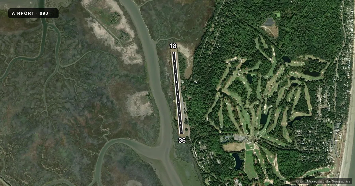
Airport sketch
Runways drawn to scale from FAA survey coordinates, rendered over satellite imagery. Not for navigation.
Approaches & charts
Services on the field
Fuel grades, oxygen, maintenance, ramp storage and lighting — as declared to the FAA by the airport operator.
Fuel & services
- Fuel
- 100LL
- Oxygen (bottled)
- Not available
- Oxygen (bulk)
- Not available
- Airframe repair
- Not available
- Power plant repair
- Not available
Ramp & ground
- Transient storage
- Tie-down
- Landing fee
- No fee published
- Customs
- Not available
- Lighting schedule
- SEE RMK
- Beacon schedule
- SS-SR
- Beacon
- White / Green (civil land)(WG)
- Wind indicator
- Lighted
- Segmented circle
- Yes
Fuel & FBOs
Cheapest 100LL and Jet A on the field and nearby. Always confirm with the FBO before taxi.
Airport notes
Surface conditions, obstructions, local procedures, lighting outages and other notes published with each FAA cycle.
General notes
- TRANSITION VIOLATIONS - 55 FT TREES E OF RY & 40 FT TREES W OF RY.
- ROTG BCN IS LCTD ON TOP OF A WATER TANK 1/2 - 1 MILE NE OF RY 18 IN A SWAMPY AREA.
- DEER ON & INVOF OF ARPT.
- FOR CD CTC JACKSONVILLE ARTCC AT 904-845-1592.
Lighting notes
- ACTVT MIRL RY 18/36 AND PAPI RY 18 & RY 36 - CTAF.
Other notes
- MANAGERJEKYLL ISLAND AUTHORITY.
VFR map & nearby airports
VFR sectional. Tap any ICAO chip to open that airport.
Key facts · 09J
Answer card- ICAO
- 09J
- Name
- JEKYLL ISLAND
- Location
- JEKYLL ISLAND, GEORGIA
- Elevation
- 11.3 ft MSL
- Traffic pattern altitude
- 1,011.3 ft MSL (1,000 AGL)
- Control tower
- Non-towered (use CTAF)
- Total runways
- 1
- Longest runway
- 18/36 · 3,715 ft
- Published ILS approaches
- 0
- Published frequencies
- 2
- Magnetic variation
- 5°
- Current flight rules
- VFR
- Current wind
- 240° at 7 kt
- Favored runway now
- RWY 18
Jekyll Island Airport sits on Jekyll Island in Georgia. Field elevation is 11.3 ft MSL. The airport has one runway. Runway 18/36 is 3,715 ft long with asphalt surface. It is a non-towered field. CTAF and UNICOM are both 123.05. No ILS approaches are published.
Pattern altitude is not published. Use the standard 1,000 ft AGL pattern for light piston operations unless the current Chart Supplement says otherwise. The field is in a low coastal setting. Expect deer on and near the airport. That matters on taxi, takeoff and landing. There are also 55-foot trees east of the runway and 40-foot trees west of the runway. Plan your arrivals and departures with that in mind.
Jekyll Island Airport has one on-field FBO. Jekyll Island Airport carries AVGAS 100LL. Call (912) 635-9330 for current service details before you go. The rotating beacon is on a water tank half to one mile northeast of runway 18 in a swampy area. Medium intensity runway lights are available on runway 18/36. The PAPI is activated on both ends through the CTAF. For clearance delivery, contact Jacksonville ARTCC at 904-845-1592. The airport manager is the Jekyll Island Authority.