METAR & TAF KJES
Current METAR
Observed 13:10Z
KJES 271310Z AUTO 00000KT 10SM CLR 30/25 A2990 RMK AO2
- Wind
- 000° @ 0 kt
- Visibility
- 10 SM
- Temp / Dew
- 30°C / 25°C
- Altimeter
- 29.90 inHg
- Clouds
- CLR
- Density alt
- 1,958 ft
- Ceiling
- Unlimited
- Rules
- VFR
Airport info & contacts
Manager on record, flight service, ARTCC, attendance schedule and pattern altitude — published by the FAA and refreshed every 28 days.
Location
- From city
- 3 NM S
- VFR sectional
- JACKSONVILLE
- ARTCC
- ZJX · JACKSONVILLE
- NOTAM facility
- MCN (NOTAM-D)
Airport manager
- Name
- MITCH SUTTON
- Phone
- 912-266-2234
- Address
- 535 AIRPORT ROAD, JESUP GA 31546
Flight service · Hours
- FSS MCN
- MACON1-800-WX-BRIEF
- Attendance
- MON-FRI · 0800-1700
Frequencies
Tap any row to copy the frequency to your clipboard.
Runways & pattern
Full pagePattern entry · RWY 11
LEFT TRAFFICRunway end performance
| End | TORA | TODA | ASDA | LDA | VGSI | Approach lights | Obstruction |
|---|---|---|---|---|---|---|---|
| 11 | — | — | — | — | PAPI 2-box left(3.75°) | — | 99', trees, 1883' from thr, 73' R of cntrln, slope 17 |
| 29 | — | — | — | — | PAPI 2-box left(3°) | MALSF | 30', trees, 1070' from thr, 369' R of cntrln, slope 29 |
Declared distances in feet. TORA = takeoff run available, TODA = takeoff distance, ASDA = accelerate-stop, LDA = landing distance.
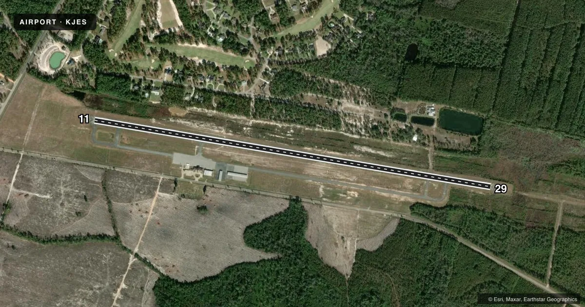
Airport sketch
Runways drawn to scale from FAA survey coordinates, rendered over satellite imagery. Not for navigation.
Approaches & charts
Services on the field
Fuel grades, oxygen, maintenance, ramp storage and lighting — as declared to the FAA by the airport operator.
Fuel & services
- Fuel
- 100LLA+
- Oxygen (bottled)
- Not available
- Oxygen (bulk)
- Not available
- Airframe repair
- Major
- Power plant repair
- Major
- Other services
- INSTR,RNTL,SALES
Ramp & ground
- Transient storage
- Tie-down
- Landing fee
- No fee published
- Customs
- Not available
- Lighting schedule
- SEE RMK
- Beacon schedule
- SS-SR
- Beacon
- White / Green (civil land)(WG)
- Wind indicator
- Lighted
- Segmented circle
- Yes
Fuel & FBOs
Cheapest 100LL and Jet A on the field and nearby. Always confirm with the FBO before taxi.
Airport notes
Surface conditions, obstructions, local procedures, lighting outages and other notes published with each FAA cycle.
General notes
- FOR CD CTC JACKSONVILLE ARTCC AT 904-845-1592.
Lighting notes
- ACTVT MIRL RY 11/29; PAPI RY 11; PAPI RY 29 & MALSF RY 29 - CTAF.
Other notes
- MANAGERARPT PHONE 912-427-5949.
VFR map & nearby airports
VFR sectional. Tap any ICAO chip to open that airport.
Key facts · KJES
Answer card- ICAO
- KJES
- Name
- JESUP-WAYNE COUNTY
- Location
- JESUP, GEORGIA
- Elevation
- 107.5 ft MSL
- Traffic pattern altitude
- 1,107.5 ft MSL (1,000 AGL)
- Control tower
- Non-towered (use CTAF)
- Total runways
- 1
- Longest runway
- 11/29 · 5,500 ft
- Published ILS approaches
- 0
- Published frequencies
- 2
- Magnetic variation
- 4°
- Current flight rules
- VFR
- Current wind
- 000° at 0 kt
- Favored runway now
- –
Jesup-Wayne County Airport sits in Jesup, Georgia. Field elevation is 107.5 ft MSL. The airport has one asphalt runway, 11/29, at 5,500 ft. There is no control tower. CTAF and UNICOM are both 122.8. No ILS approaches are published here.
Pattern altitude is not published in the facts, so use the standard 1,000 ft AGL for light piston traffic unless the current Chart Supplement says otherwise. The runway lighting is useful after dark. Medium intensity runway lights are on 11/29. PAPI is available on both runway ends. Runway 29 also has a medium intensity approach lighting system with sequenced flashing lights that is controlled by CTAF.
SutAir Flying Service is on the field. It carries 100LL and Jet A. The airport phone number in the Chart Supplement is 912-427-5949. For clearance delivery, contact Jacksonville ARTCC at 904-845-1592. If you are planning IFR or a night arrival, verify current procedures and any local notes with the current FAA Chart Supplement before you go. This is a non-towered field, so expect self-announce traffic and keep a close eye on pattern flow.