METAR & TAF KSSI
Current METAR
Observed 14:55Z
KSSI 271455Z AUTO 00000KT 10SM CLR 31/25 A2986 RMK AO2
- Wind
- 000° @ 0 kt
- Visibility
- 10 SM
- Temp / Dew
- 31°C / 25°C
- Altimeter
- 29.86 inHg
- Clouds
- CLR
- Density alt
- 2,018 ft
- Ceiling
- Unlimited
- Rules
- VFR
Airport info & contacts
Manager on record, flight service, ARTCC, attendance schedule and pattern altitude — published by the FAA and refreshed every 28 days.
Location
- From city
- 1 NM N
- VFR sectional
- JACKSONVILLE
- ARTCC
- ZJX · JACKSONVILLE
- NOTAM facility
- SSI (NOTAM-D)
Airport manager
- Name
- ROBERT BURR
- Phone
- 912-265-2070
- Address
- 295 AVIATION PARKWAY, SUITE 205, BRUNSWICK GA 31525
Flight service · Hours
- FSS MCN
- MACON1-800-WX-BRIEF
- Attendance
- 0700-2000
Frequencies
Tap any row to copy the frequency to your clipboard.
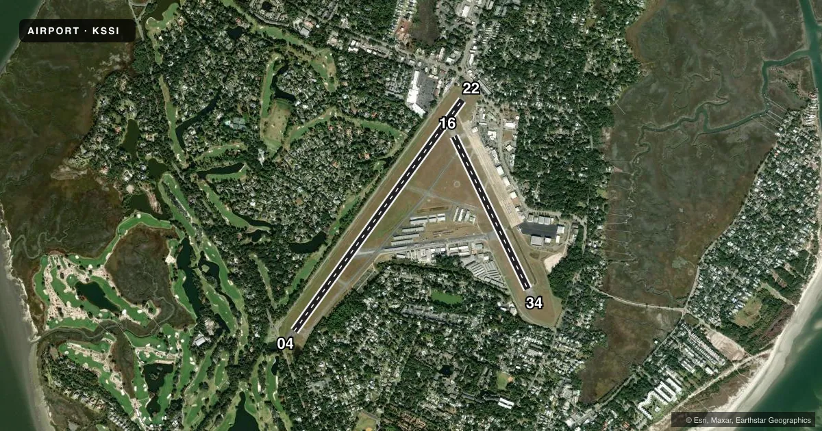
Runways & pattern
Full pagePattern entry · RWY 04
LEFT TRAFFIC| Runway | Heading (°M) | Length | Surface | Traffic |
|---|---|---|---|---|
| 04/22 | 31° / 211° | 5,584 ft | ASPH | Standard L |
| 16/34 | 149° / 329° | 3,313 ft | ASPH | Standard L |
Runway end performance
| End | TORA | TODA | ASDA | LDA | VGSI | Approach lights | Obstruction |
|---|---|---|---|---|---|---|---|
| 04 | 5,580' | 5,580' | 5,580' | 4,798' | PAPI 2-box left(4°) | — | 15', road, 215' from thr, 256' R of cntrln, slope 0 |
| 22 | 5,580' | 5,580' | 5,580' | 4,671' | PAPI 2-box left(4°) | — | 21', bldg, 232' from thr, 251' R of cntrln, slope 1 |
| 16 | — | — | — | — | PAPI 2-box left(3.25°) | — | 30', trees, 740' from thr, 150' R of cntrln, slope 18 |
| 34 | — | — | — | — | PAPI 2-box left(3.75°) | — | 47', trees, 845' from thr, 150' R of cntrln, slope 13 |
Declared distances in feet. TORA = takeoff run available, TODA = takeoff distance, ASDA = accelerate-stop, LDA = landing distance.
Airport sketch
Runways drawn to scale from FAA survey coordinates, rendered over satellite imagery. Not for navigation.
Approaches & charts
Services on the field
Fuel grades, oxygen, maintenance, ramp storage and lighting — as declared to the FAA by the airport operator.
Fuel & services
- Fuel
- 100LLAA+
- Oxygen (bottled)
- HIGH/LOW
- Oxygen (bulk)
- HIGH/LOW
- Airframe repair
- Major
- Power plant repair
- Minor
- Other services
- CHTR,INSTR,RNTL,SALES
Ramp & ground
- Transient storage
- Tie-down
- Hangar
- Landing fee
- No fee published
- Customs
- Not available
- Lighting schedule
- SEE RMK
- Beacon schedule
- SS-SR
- Beacon
- White / Green (civil land)(WG)
- Wind indicator
- Lighted
- Segmented circle
- Yes
Fuel & FBOs
Cheapest 100LL and Jet A on the field and nearby. Always confirm with the FBO before taxi.
Airport notes
Surface conditions, obstructions, local procedures, lighting outages and other notes published with each FAA cycle.
General notes
- BIRDS AND WILDLIFE ON & INVOF ARPT.
- USE CTN DUE TO CONGESTED ASP WITH TURBINE, NONTURBINE, AND TRNG ACFT. BQK LOCATED 7NM NW. JEKYLL ISLAND AP 09J LOCATED 4NM S USING SAME CTAF FREQ 123.05.
- RWY 22 PREF FOR LIGHT AND VRB WINDS OR CROSSWINDS.
- ALL VFR ACFT ADHERE TO STD LH TFC PAT.
- ACFT DEPARTING RWY 34 USE EXTRM CTN- APCH END OF RWY 04 NOT VSB FROM APCH END OF RWY 34.
- ALL ARRIVALS AND DEPARTURES, INCLUDING ACFT FLYING INST APPROACHES, ARE REQSTD TO RPRT 10 MILES FROM THE AP, INTNS AND PSN REPORTS TO -ST SIMONS- CTAF 123.05.
- PPR FOR SVC AND FUEL AFTER HRS CALL 912-638-8617.
- ADJ RESIDENTIAL AREA TO THE SE AND SSW OF RWY 16/34 EXTREMELY NOISE SENSITIVE.
- PREF NOISE-ABATEMENT ARRIVAL FOR HEL TFC IS A STRAIGHT-IN TO RWY 34 THEN A MID-FIELD TURN TO LDG. ALL WHEELED HEL GND TAXI TO FINAL PRKG.
- ADDITIONAL APT SAFETY BULLETINS POSTED AT WWW.FLYGCAIRPORTS.COM/SAFETY.
- FOR CD CTC JACKSONVILLE ARTCC AT 904-845-1592.
- FBO SVCS AVBL ON 130.65.
- TRG FLTS ARE ENCOURAGED TO USE BRUNSWICK GOLDEN ISLES ARPT LCTD 7 NM NW OF ST. SIMONS ISLAND ARPT FOR OPS.
Lighting notes
- ACTVT REIL RWY 04; HIRL RWY 04/22 & 16/34 - CTAF.
Approach & departure obstructions
- 04+6 FT FENCE, +32 FT POWER POLE, +12 FT BUSH 75-200 FT FROM END OF RWY 228-250 FT LEFT.
- 226 FT FENCE 190 FT RIGHT OF CNTRLN, 140 FT FROM E.O.R.
- 04APCH RATIO 25:1 TO DSPLCD THR; 26 FT TREES 650 FT OUT AND 300 FT RIGHT.
- 22APCH RATIO 50:1 TO DSPLCD THR.
Other notes
- EXISTED PRIOR TO 1959.
VFR map & nearby airports
VFR sectional. Tap any ICAO chip to open that airport.
Key facts · KSSI
Answer card- ICAO
- KSSI
- Name
- ST SIMONS ISLAND
- Location
- ST SIMONS ISLAND, GEORGIA
- Elevation
- 18.9 ft MSL
- Traffic pattern altitude
- 1,018.9 ft MSL (1,000 AGL)
- Control tower
- Non-towered (use CTAF)
- Total runways
- 2
- Longest runway
- 04/22 · 5,584 ft
- Published ILS approaches
- 0
- Published frequencies
- 2
- Magnetic variation
- 5°
- Current flight rules
- VFR
- Current wind
- 000° at 0 kt
- Favored runway now
- –
St Simons Island Airport (KSSI) sits on St Simons Island in Georgia. Field elevation is 18.9 ft MSL. The airport has two asphalt runways. The longest is 04/22 at 5,584 ft. There is no control tower. No ILS approaches are published. Pattern altitude is not published, so use the standard 1,000 ft AGL for light piston traffic unless the current FAA Chart Supplement says otherwise.
Velocity Aviation, formerly Odyssey Aviation, is on the field. It carries 100LL, Jet A and Jet A Prist. Fixed base operator services are available on frequency 130.65. CTAF and UNICOM are both 123.05.
This is a noise-sensitive airport. The residential area southeast and south-southwest of runway 16/34 is especially sensitive. Runway 22 is the preferred runway for light and variable winds or crosswinds. The published remarks also call out birds and wildlife in and around the airport. All VFR aircraft use the standard left-hand pattern. Arrivals and departures are requested to call 10 miles out with position and intentions on CTAF 123.05. Training flights are encouraged to use Brunswick Golden Isles Airport 7 NM northwest. Jekyll Island Airport is 4 NM south. It uses the same CTAF, so expect busy local traffic in the area.