METAR & TAF 42J
Current METAR
Observed 16:35Z
K42J 271635Z AUTO 30008KT 10SM CLR 31/25 A2991 RMK A01
- Wind
- 300° @ 8 kt
- Visibility
- 10 SM
- Temp / Dew
- 31°C / 25°C
- Altimeter
- 29.91 inHg
- Clouds
- CLR
- Density alt
- 2,175 ft
- Ceiling
- Unlimited
- Rules
- VFR
Airport info & contacts
Manager on record, flight service, ARTCC, attendance schedule and pattern altitude — published by the FAA and refreshed every 28 days.
Location
- From city
- 3 NM N
- VFR sectional
- JACKSONVILLE
- ARTCC
- ZJX · JACKSONVILLE
- NOTAM facility
- GNV (NOTAM-D)
Airport manager
- Name
- CRAIG COON
- Phone
- 352-473-0031
- Address
- 7150 AIRPORT RD, 7150 AIRPORT ROAD, STARKE FL 32091-9347
Flight service · Hours
- FSS GNV
- GAINESVILLE1-800-WX-BRIEF
- Attendance
- MON-FRI · 0800-1700
Frequencies
Tap any row to copy the frequency to your clipboard.
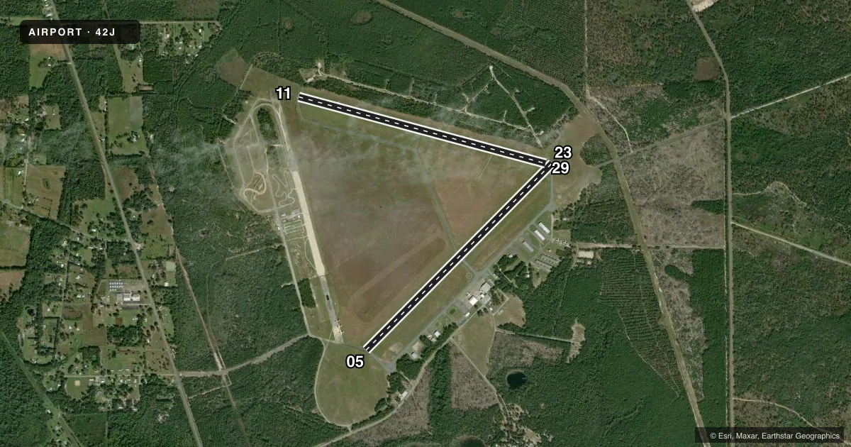
Runways & pattern
Full pagePattern entry · RWY 29
RIGHT TRAFFIC| Runway | Heading (°M) | Length | Surface | Traffic |
|---|---|---|---|---|
| 05/23 | 40° / 220° | 5,046 ft | ASPH | 05 R |
| 11/29Favored | 100° / 280° | 4,899 ft | ASPH | 29 R |
Runway end performance
| End | TORA | TODA | ASDA | LDA | VGSI | Approach lights | Obstruction |
|---|---|---|---|---|---|---|---|
| 05 | — | — | — | — | PAPI 2-box left(3°) | — | 49', trees, 1840' from thr, 220' R of cntrln, slope 33 |
| 23 | — | — | — | — | PAPI 2-box left(3°) | — | 39', trees, 1175' from thr, 235' R of cntrln, slope 25 |
| 11 | — | — | — | — | PAPI 2-box left(3°) | — | 40', trees, 1200' from thr, 0' R of cntrln, slope 25 |
| 29 | — | — | — | — | PAPI 2-box left(3°) | — | 48', trees, 1160' from thr, 100' R of cntrln, slope 20 |
Declared distances in feet. TORA = takeoff run available, TODA = takeoff distance, ASDA = accelerate-stop, LDA = landing distance.
Airport sketch
Runways drawn to scale from FAA survey coordinates, rendered over satellite imagery. Not for navigation.
Approaches & charts
Services on the field
Fuel grades, oxygen, maintenance, ramp storage and lighting — as declared to the FAA by the airport operator.
Fuel & services
- Fuel
- 100LLA+
- Oxygen (bottled)
- Not available
- Oxygen (bulk)
- Not available
- Airframe repair
- Major
- Power plant repair
- Major
- Other services
- CHTR,INSTR,RNTL
Ramp & ground
- Transient storage
- Tie-down
- Landing fee
- No fee published
- Customs
- Not available
- Lighting schedule
- SEE RMK
- Beacon schedule
- SS-SR
- Beacon
- White / Green (civil land)(WG)
- Wind indicator
- Lighted
Fuel & FBOs
Cheapest 100LL and Jet A on the field and nearby. Always confirm with the FBO before taxi.
Airport notes
Surface conditions, obstructions, local procedures, lighting outages and other notes published with each FAA cycle.
General notes
- ANIMALS ON AND INVOF ARPT.
- RSTRD AREA 2903A 1.5 NM RWY 23 END. FLY R TFC TO AVOID.
- RWYS 11/29 RSTRD BY AMGR TO ACFT 12500 LBS GWT OR LESS.
- SELF SERVE AVGAS AVBL 24 HRS WITH CREDIT CARD. JET A BY APPOINTMENT. CALL 352-473-0031.
- RWY 5/23 WEIGHT BEARING CAPACITY 2S-155.
- FOR CD CTC JACKSONVILLE APCH AT 904-741-0284.
Lighting notes
- SS-SR ACTVT REIL RWY 05, 23, & 11; MIRL RWY 05/23 & 11/29 - CTAF. PAPI OPR CONSLY.
Other notes
- EXISTED PRIOR TO 1959.
VFR map & nearby airports
VFR sectional. Tap any ICAO chip to open that airport.
Key facts · 42J
Answer card- ICAO
- 42J
- Name
- KEYSTONE HEIGHTS
- Location
- KEYSTONE HEIGHTS, FLORIDA
- Elevation
- 195.6 ft MSL
- Traffic pattern altitude
- 1,195.6 ft MSL (1,000 AGL)
- Control tower
- Non-towered (use CTAF)
- Total runways
- 2
- Longest runway
- 05/23 · 5,046 ft
- Published ILS approaches
- 0
- Published frequencies
- 4
- Magnetic variation
- 5°
- Current flight rules
- VFR
- Current wind
- 300° at 8 kt
- Favored runway now
- RWY 29
Keystone Heights Airport is in Keystone Heights, Florida. The field elevation is 195.6 ft MSL. It has two asphalt runways. The longest is runway 05/23 at 5,046 ft. There is no control tower. No ILS approaches are published. Pattern altitude is not published, so use the standard 1,000 ft AGL for light piston operations unless current local guidance says otherwise.
The on-field FBO is Keystone Heights Airport. It carries 100LL and Jet A Prist. Self-serve avgas is available 24 hours with a credit card. Jet A is available by appointment. Call the FBO at (352) 473-0031 before arrival if you need fuel or ramp details.
Runway 11/29 is restricted to aircraft at 12,500 lb gross weight or less. Runway 05/23 has a weight bearing capacity of 2S-155. The published remarks also note animals on and near the airport. Runway end identifier lights are active from sunset to sunrise on runways 05, 23 and 11. Medium intensity runway lights on 05/23 and 11/29 are controlled by CTAF. The precision approach path indicators operate continuously.
This is a non-towered field with Jacksonville Approach handling clearance delivery and approach support. Check the current FAA Chart Supplement for any changes before you go. Right traffic is published for runway 23 to help avoid restricted area 2903A 1.5 NM from that end.