METAR & TAF 0J8
0J8 does not publish a METAR.
Showing the nearest reporting station: KGNV (GAINESVILLE RGNL) · 13.1 NM away. Conditions at 0J8 may differ.
METAR · KGNV
Observed 16:53Z
KGNV 271653Z 31004KT 8SM -RA FEW070 SCT090 31/24 A2994 RMK AO2 RAB53 SLP133 P0000 T03060239
- Wind
- 310° @ 4 kt
- Visibility
- 8 SM
- Temp / Dew
- 31°C / 24°C
- Altimeter
- 29.94 inHg
- Clouds
- SCT
- Density alt
- 2,009 ft
- Ceiling
- Unlimited
- Rules
- VFR
Airport info & contacts
Manager on record, flight service, ARTCC, attendance schedule and pattern altitude — published by the FAA and refreshed every 28 days.
Location
- From city
- 5 NM N
- VFR sectional
- JACKSONVILLE
- ARTCC
- ZJX · JACKSONVILLE
- NOTAM facility
- GNV (NOTAM-D)
Airport manager
- Name
- TJ FRASIER
- Phone
- 352-682-0151
- Address
- 3808 NORTHWEST 154TH ST, ARCHER FL 32618
Flight service · Hours
- FSS GNV
- GAINESVILLE1-800-WX-BRIEF
- Attendance
- Unattended
Frequencies
Tap any row to copy the frequency to your clipboard.
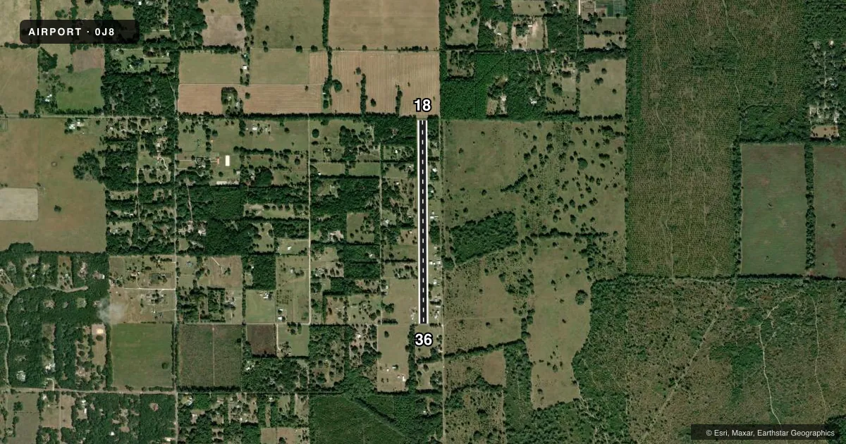
Runways & pattern
Full pagePattern entry · RWY 36
LEFT TRAFFICRunway end performance
| End | TORA | TODA | ASDA | LDA | VGSI | Approach lights | Obstruction |
|---|---|---|---|---|---|---|---|
| 18 | — | — | — | — | — | — | 47', trees, 2095' from thr, 60' R of cntrln, slope 45 |
| 36 | — | — | — | — | — | — | 5', fence, 4' from thr, 0' R of cntrln, slope 0 |
Declared distances in feet. TORA = takeoff run available, TODA = takeoff distance, ASDA = accelerate-stop, LDA = landing distance.
Airport sketch
Runways drawn to scale from FAA survey coordinates, rendered over satellite imagery. Not for navigation.
Approaches & charts
Services on the field
Fuel grades, oxygen, maintenance, ramp storage and lighting — as declared to the FAA by the airport operator.
Fuel & services
- Fuel
- Not available
- Oxygen (bottled)
- Not available
- Oxygen (bulk)
- Not available
- Airframe repair
- Major
- Power plant repair
- Major
- Other services
- AVNCS,INSTR
Ramp & ground
- Transient storage
- Tie-down
- Landing fee
- No fee published
- Lighting schedule
- SEE RMK
- Wind indicator
- Yes
- Segmented circle
- No
Fuel & FBOs
Cheapest 100LL and Jet A on the field and nearby. Always confirm with the FBO before taxi.
Airport notes
Surface conditions, obstructions, local procedures, lighting outages and other notes published with each FAA cycle.
General notes
- ACFT MAINTENANCE AND TRANSPONDER AND ALTIMETER CERTIFICATION AVBL.
- FOR CD CTC JACKSONVILLE APCH AT 904-741-0284.
- UNLGTD TREES & FENCE 100 FT WEST & EAST OF RWY 18/36 CNTLN INSIDE PRI SFC.
- WINDSOCK AND THRS UNLGTD.
Lighting notes
- ACTVT LIRL RWY 18/36 - CTAF.
Runway surface & condition
- 18/36RWY 18/36 NSTD LIRL SPACING. LGTS VERY LOW INTST. RWY 18/36 MKD WITH PAVERS & LGTS.
Approach & departure obstructions
- 18TREES 100 FT RIGHT & LEFT INSIDE PRI SFC.
- 36FENCE 100 FT LEFT INSIDE PRI SFC.
- 36RWY 36 20:1 APCH TO THE DSPLCD THLD DUE TO 55 FT TREES; 735 FT FROM RWY END; 25 RIGHT OF RWY CNTRLN.
Other notes
- VFR OPNS ONLY.
VFR map & nearby airports
VFR sectional. Tap any ICAO chip to open that airport.
Key facts · 0J8
Answer card- ICAO
- 0J8
- Name
- FLYING TEN
- Location
- ARCHER, FLORIDA
- Elevation
- 92 ft MSL
- Traffic pattern altitude
- 1,092 ft MSL (1,000 AGL)
- Control tower
- Non-towered (use CTAF)
- Total runways
- 1
- Longest runway
- 18/36 · 3,917 ft
- Published ILS approaches
- 0
- Published frequencies
- 1
- Magnetic variation
- 2°
- Current flight rules
- VFR
- Current wind
- 310° at 4 kt
- Favored runway now
- RWY 36
FLYING TEN (0J8) is in Archer, Florida. Field elevation is 92 ft MSL. The airport has one runway. Runway 18/36 is 3,917 ft long and is turf. There is no control tower. No ILS approaches are published. VFR flight only is noted in the remarks. Pattern altitude is not published, so use the standard 1,000 ft AGL pattern unless the current Chart Supplement says otherwise.
The runway has low intensity lighting on 18/36. The lights are activated by the CTAF. The runway is marked with pavers and lights. The windsock and threshold are unlighted. Trees are close in the primary surface near runway 18. Runway 36 has a displaced threshold issue tied to a tree on the approach path. There is also a fence near runway 36. That makes a careful stabilized approach important, especially if you are new to the field.
No on-field FBOs are listed. Aircraft maintenance plus transponder and altimeter certification are available on field. CTAF is 122.9. For clearance delivery, contact Jacksonville Approach at 904-741-0284. If you need current noise, lighting, or operational details before launch, check the current FAA Chart Supplement or call the airport operator directly.