METAR & TAF KCTY
Current METAR
Observed 13:15Z
KCTY 271315Z AUTO 33007KT 10SM CLR 30/27 A2991 RMK AO2 LTG DSNT S-W
- Wind
- 330° @ 7 kt
- Visibility
- 10 SM
- Temp / Dew
- 30°C / 27°C
- Altimeter
- 29.91 inHg
- Clouds
- CLR
- Density alt
- 1,865 ft
- Ceiling
- Unlimited
- Rules
- VFR
Airport info & contacts
Manager on record, flight service, ARTCC, attendance schedule and pattern altitude — published by the FAA and refreshed every 28 days.
Location
- From city
- 1 NM E
- VFR sectional
- JACKSONVILLE
- ARTCC
- ZJX · JACKSONVILLE
- NOTAM facility
- GNV (NOTAM-D)
Airport manager
- Name
- CLINT BEAUCHAMP
- Phone
- 352-498-6656
- Address
- 508 NE 241 ST, 508 NE 241 ST, CROSS CITY FL 32628
Flight service · Hours
- FSS GNV
- GAINESVILLE1-800-WX-BRIEF
- Attendance
- 0800-1700
Frequencies
Tap any row to copy the frequency to your clipboard.
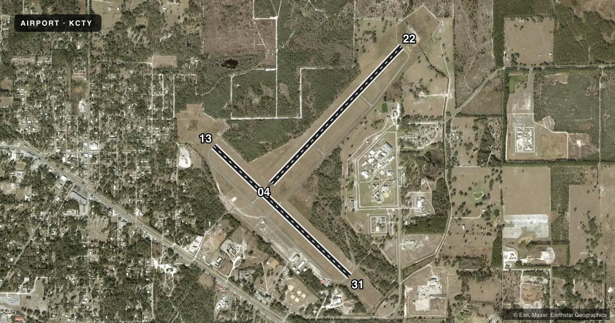
Runways & pattern
Full pagePattern entry · RWY 31
LEFT TRAFFIC| Runway | Heading (°M) | Length | Surface | Traffic |
|---|---|---|---|---|
| 04/22 | 39° / 219° | 5,005 ft | ASPH | Standard L |
| 13/31Favored | 129° / 309° | 5,001 ft | ASPH-CONC | Standard L |
Runway end performance
| End | TORA | TODA | ASDA | LDA | VGSI | Approach lights | Obstruction |
|---|---|---|---|---|---|---|---|
| 04 | — | — | — | — | PAPI 2-box left(3°) | — | 55', trees, 1355' from thr, 150' R of cntrln, slope 21 |
| 22 | — | — | — | — | PAPI 2-box left(3°) | — | 63', trees, 1270' from thr, 60' R of cntrln, slope 17 |
| 13 | — | — | — | — | PAPI 2-box left(3°) | — | 56', trees, 1430' from thr, 250' R of cntrln, slope 22 |
| 31 | — | — | — | — | PAPI 2-box left(3°) | — | 47', trees, 1800' from thr, 60' R of cntrln, slope 34 |
Declared distances in feet. TORA = takeoff run available, TODA = takeoff distance, ASDA = accelerate-stop, LDA = landing distance.
Airport sketch
Runways drawn to scale from FAA survey coordinates, rendered over satellite imagery. Not for navigation.
Approaches & charts
Services on the field
Fuel grades, oxygen, maintenance, ramp storage and lighting — as declared to the FAA by the airport operator.
Fuel & services
- Fuel
- 100LLA
- Oxygen (bottled)
- Not available
- Oxygen (bulk)
- Not available
- Airframe repair
- Major
- Power plant repair
- Major
Ramp & ground
- Transient storage
- Tie-down
- Landing fee
- No fee published
- Customs
- Not available
- Lighting schedule
- SEE RMK
- Beacon schedule
- SS-SR
- Beacon
- White / Green (civil land)(WG)
- Wind indicator
- Lighted
- Segmented circle
- Yes
Fuel & FBOs
Cheapest 100LL and Jet A on the field and nearby. Always confirm with the FBO before taxi.
Airport notes
Surface conditions, obstructions, local procedures, lighting outages and other notes published with each FAA cycle.
General notes
- RY 04/22 HAS TREES IN TRANSITION SFC NORTHWEST.
- FOR CD IF UNA TO CTC ON FSS FREQ, CTC JACKSONVILLE ARTCC AT 904-845-1592.
Lighting notes
- ACTVT REIL 13 & 31; PAPI RWY 04, 22, 13 & 31; MIRL RWY 04/22 - CTAF.
Approach & departure obstructions
- 13RWY 13 MRKGS FADED.
- 31RWY 31 MRKGS FADED.
Other notes
- THIS AIRPORT HAS BEEN SURVEYED BY THE NATIONAL GEODETIC SURVEY.
- MANAGERAIRPORT PHYSICAL ADDRESS: 1516 AIRPORT ROAD., CROSS CITY, FL 32628, 352-498-1200
- OWNERCONTACT PERSON: JOHN JENKINS, 352-498-1426 FAX: 352-498-1207
- 13/31FIRST 300 FT RWY 31 CONC.
VFR map & nearby airports
VFR sectional. Tap any ICAO chip to open that airport.
Key facts · KCTY
Answer card- ICAO
- KCTY
- Name
- CROSS CITY
- Location
- CROSS CITY, FLORIDA
- Elevation
- 42.1 ft MSL
- Traffic pattern altitude
- 1,042.1 ft MSL (1,000 AGL)
- Control tower
- Non-towered (use CTAF)
- Total runways
- 2
- Longest runway
- 04/22 · 5,005 ft
- Published ILS approaches
- 0
- Published frequencies
- 2
- Magnetic variation
- 5°
- Current flight rules
- VFR
- Current wind
- 330° at 7 kt
- Favored runway now
- RWY 31
Cross City Airport sits in Cross City, Florida. Field elevation is 42.1 ft MSL. The airport has two runways. The longest is 5,005 ft. There is no control tower, so use CTAF 122.8 for self-announce traffic. No ILS approaches are published here.
Pattern altitude is not published. For light piston operations, plan on the standard 1,000 ft AGL unless the current Chart Supplement says otherwise. Dixie Aviation Services is on the field. It carries 100LL and Jet A Prist. Runway 04/22 has medium intensity lights. Runways 04, 22, 13 and 31 have PAPI. Runways 13 and 31 also have REIL. Runway 13 markings are faded. Runway 31 markings are faded. The first 300 ft of runway 31 is concrete.
This is a non-towered field, so keep your scan tight and make your calls early. Runway 04/22 has trees in the transition surface northwest. That is worth checking before arrival, especially if you are planning a low approach or a night landing. If you need clearance delivery and cannot raise Flight Service, the published contact is Jacksonville ARTCC. Use the current FAA Chart Supplement for any updated operational notes before you go.