METAR & TAF KCDK
KCDK does not publish a METAR.
Showing the nearest reporting station: KCGC (CRYSTAL RIVER/DAVIS FLD) · 29.7 NM away. Conditions at KCDK may differ.
METAR · KCGC
Observed 13:35Z
KCGC 271335Z AUTO 00000KT 10SM CLR 26/25 A2992 RMK AO2 LTG DSNT S AND SW
- Wind
- 000° @ 0 kt
- Visibility
- 10 SM
- Temp / Dew
- 26°C / 25°C
- Altimeter
- 29.92 inHg
- Clouds
- CLR
- Density alt
- 1,334 ft
- Ceiling
- Unlimited
- Rules
- VFR
Airport info & contacts
Manager on record, flight service, ARTCC, attendance schedule and pattern altitude — published by the FAA and refreshed every 28 days.
Location
- From city
- 1 NM W
- VFR sectional
- JACKSONVILLE
- ARTCC
- ZJX · JACKSONVILLE
- NOTAM facility
- GNV (NOTAM-D)
Airport manager
- Name
- ALICE LALONDE
- Phone
- 352-486-3358
- Address
- PO BOX 336, PO BOX 310, BRONSON FL 32621
Flight service · Hours
- FSS GNV
- GAINESVILLE1-800-WX-BRIEF
- Attendance
- Unattended
Frequencies
Tap any row to copy the frequency to your clipboard.
Runways & pattern
Full pagePattern entry · RWY 05
LEFT TRAFFICRunway end performance
| End | TORA | TODA | ASDA | LDA | VGSI | Approach lights | Obstruction |
|---|---|---|---|---|---|---|---|
| 05 | — | — | — | — | — | — | 10', brush, 205' from thr, 125' R of cntrln, slope 0 |
| 23 | — | — | — | — | — | — | 15', road, 40' from thr, 0' R of cntrln, slope 0 |
Declared distances in feet. TORA = takeoff run available, TODA = takeoff distance, ASDA = accelerate-stop, LDA = landing distance.
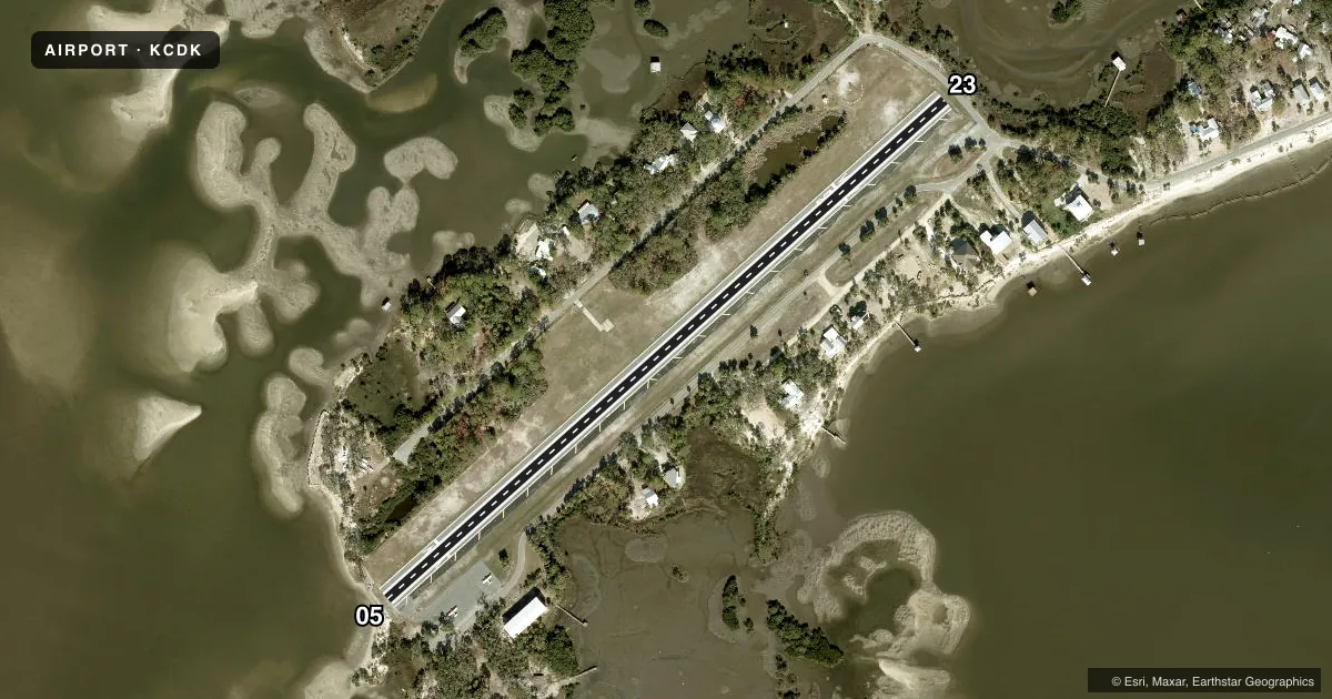
Airport sketch
Runways drawn to scale from FAA survey coordinates, rendered over satellite imagery. Not for navigation.
Approaches & charts
Services on the field
Fuel grades, oxygen, maintenance, ramp storage and lighting — as declared to the FAA by the airport operator.
Fuel & services
- Fuel
- Not available
- Oxygen (bottled)
- Not available
- Oxygen (bulk)
- Not available
- Airframe repair
- Not available
- Power plant repair
- Not available
Ramp & ground
- Transient storage
- Tie-down
- Landing fee
- No fee published
- Customs
- Not available
- Lighting schedule
- SEE RMK
- Beacon schedule
- SS-SR
- Beacon
- White / Green (civil land)(WG)
- Wind indicator
- Lighted
- Segmented circle
- Yes
Fuel & FBOs
Cheapest 100LL and Jet A on the field and nearby. Always confirm with the FBO before taxi.
Airport notes
Surface conditions, obstructions, local procedures, lighting outages and other notes published with each FAA cycle.
General notes
- SEA GULLS ON RY.
- TWY CLSD TO ACFT, USED AS PUBLIC ROAD.
- 4 FT FENCE 125 FT FM RY CENTERLINE LOCATED 400 FT 'NE' OF RY 23 THRLD & PARRALLEL TO PUBLIC ROAD.
- FOR CD CTC JACKSONVILLE ARTCC AT 904-845-1592.
- RWY 23 HAS 15 FT ROAD 40 FT BFR AER.
- AIRPORT LGTS ARE NOT RELIABLE.
- HEL PRKG PAD NW OF RWY 05/23 IS FOR EUO.
Lighting notes
- ACTVT REIL RWY 05 & 23; MIRL RWY 5/23 - CTAF.
Approach & departure obstructions
- 23RWY 23 HAS 15 FT ROAD 40 FT BFR END OF RWY.
- 05CTLG OBSTN EXCEEDS A 45 DEG SLP. RWY 05 APRCH 34:1 TO DTHR.
- 23RWY 23 APCH RATIO 38:1 TO DTHR.
Other notes
- EXISTED PRIOR TO 1959.
- WINDSOCK ON NON-FRANGIBLE POLE.
- MANAGERAIRPORT PHYSICAL ADDRESS: 14703 SOUTHWEST AIRPORT RD., CEDAR KEY, FL 32625
VFR map & nearby airports
VFR sectional. Tap any ICAO chip to open that airport.
Key facts · KCDK
Answer card- ICAO
- KCDK
- Name
- GEORGE T LEWIS
- Location
- CEDAR KEY, FLORIDA
- Elevation
- 11 ft MSL
- Traffic pattern altitude
- 1,011 ft MSL (1,000 AGL)
- Control tower
- Non-towered (use CTAF)
- Total runways
- 1
- Longest runway
- 05/23 · 2,302 ft
- Published ILS approaches
- 0
- Published frequencies
- 1
- Magnetic variation
- 2°
- Current flight rules
- VFR
- Current wind
- 000° at 0 kt
- Favored runway now
- –
George T Lewis Airport (KCDK) is in Cedar Key, Florida. Field elevation is 11 ft MSL. The airport has one runway. Runway 05/23 is 2,302 ft long and asphalt. There is no control tower. CTAF is 122.9.
No ILS approaches are published here. Pattern altitude is not published, so use the standard 1,000 ft AGL for light piston operations unless the current FAA Chart Supplement says otherwise. The field sits in a low coastal area. Expect sea breeze changes and pay close attention to winds and surface conditions. Published remarks also note that seagulls are present on the runway. Airport lights are not reliable, so night operations deserve extra caution.
There are no on-field FBOs listed. Plan on confirming services with the airport operator or the field directly before arrival. The published remarks also flag runway 05 obstacle issues near the approach. Runway 23 has a road close to the departure end. There is also an obstacle clearance slope on approach. The taxiway is closed to aircraft and used as a public road. The helicopter pad northwest of runway 05/23 is for emergency use only. For clearance delivery, contact Jacksonville ARTCC at 904-845-1592.