METAR & TAF KOCF
Current METAR
Observed 14:51Z
KOCF 271451Z 33007KT 300V360 10SM SCT025 32/25 A2991 RMK AO2 SLP128 6//// T03220250 58002 PNO $
- Wind
- 330° @ 7 kt
- Visibility
- 10 SM
- Temp / Dew
- 32°C / 25°C
- Altimeter
- 29.91 inHg
- Clouds
- SCT
- Density alt
- 2,164 ft
- Ceiling
- Unlimited
- Rules
- VFR
Airport info & contacts
Manager on record, flight service, ARTCC, attendance schedule and pattern altitude — published by the FAA and refreshed every 28 days.
Location
- From city
- 4 NM W
- VFR sectional
- JACKSONVILLE
- ARTCC
- ZJX · JACKSONVILLE
- NOTAM facility
- OCF (NOTAM-D)
Airport manager
- Name
- MATTHEW GROW
- Phone
- 352-629-8377
- Address
- 1770 SW 60TH AVE, SUITE 600, OCALA FL 34474
Flight service · Hours
- FSS GNV
- GAINESVILLE1-800-WX-BRIEF
- Attendance
- 0600-2100
Frequencies
Tap any row to copy the frequency to your clipboard.
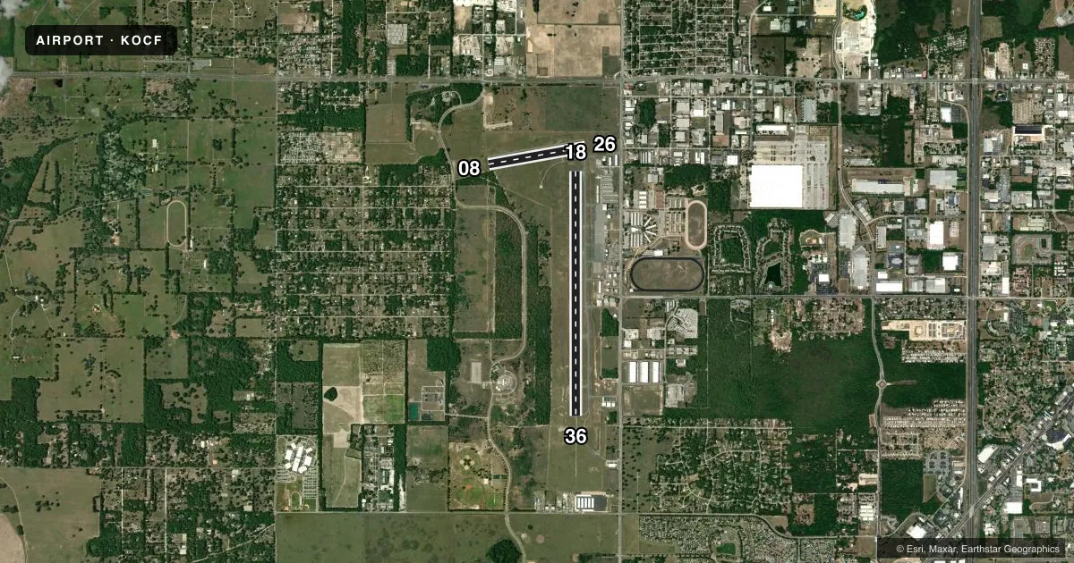
Runways & pattern
Full pagePattern entry · RWY 36
LEFT TRAFFIC| Runway | Heading (°M) | Length | Surface | Traffic |
|---|---|---|---|---|
| 18/36Favored | 176° / 356° | 7,468 ft | ASPH | Standard L |
| 08/26 | 76° / 256° | 3,010 ft | ASPH | Standard L |
Runway end performance
| End | TORA | TODA | ASDA | LDA | VGSI | Approach lights | Obstruction |
|---|---|---|---|---|---|---|---|
| 18 | 7,468' | 7,468' | 6,718' | 6,558' | PAPI 4-box left(3°) | — | 60', trees, 2600' from thr, 530' R of cntrln, slope 40 |
| 36 | 7,468' | 7,468' | 6,911' | 6,351' | PAPI 4-box left(3°) | MALSR | 46', tree, 2530' from thr, 410' R of cntrln, slope 50 |
| 08 | — | — | — | — | — | — | 50', trees, 1205' from thr, 105' R of cntrln, slope 20 |
| 26 | — | — | — | — | — | — | 25', pline, 1045' from thr, 170' R of cntrln, slope 34 |
Declared distances in feet. TORA = takeoff run available, TODA = takeoff distance, ASDA = accelerate-stop, LDA = landing distance.
Airport sketch
Runways drawn to scale from FAA survey coordinates, rendered over satellite imagery. Not for navigation.
Approaches & charts
ILS · 1
Services on the field
Fuel grades, oxygen, maintenance, ramp storage and lighting — as declared to the FAA by the airport operator.
Fuel & services
- Fuel
- 100LLA1+
- Oxygen (bottled)
- High pressure
- Oxygen (bulk)
- HIGH/LOW
- Airframe repair
- Major
- Power plant repair
- Major
- Other services
- AVNCS,CHTR,INSTR,RNTL,SALES
Ramp & ground
- Transient storage
- Tie-down
- Hangar
- Landing fee
- No fee published
- Customs
- Not available
- Lighting schedule
- SEE RMK
- Beacon schedule
- SS-SR
- Beacon
- White / Green (civil land)(WG)
- Wind indicator
- Lighted
- Segmented circle
- Yes
Fuel & FBOs
Cheapest 100LL and Jet A on the field and nearby. Always confirm with the FBO before taxi.
Airport notes
Surface conditions, obstructions, local procedures, lighting outages and other notes published with each FAA cycle.
General notes
- ACFT DEP RWY 18 MNTN RWY HDG TO 800 FT AGL OR TIL RCHG END OF RWY WHICHEVER OCRS LTR BFR MAKING LEFT TURNS.
- TWY A1, A8, A9 & A12 E OF TWY A; TWY A NORTH OF TWY A2; CLSD TO ACR.
- CUSTOM SVC UNAVBL.
- SFC CONDS NOT RPRTD 1700-0700L.
- FOR CD IF UNA TO CTC ON FSS FREQ, CTC JACKSONVILLE APCH AT 904-741-0284.
- TWY A1 RSTRD TO ACFT WITH WINGSPAN 60 FT OR LESS.
- OBJECT 2.5 FT AGL LCTD 39 FT NORTH OF TWY A1 CNTRLN.
- RWY 36 RTHL NOT STD.
- RWY 18/36 REDL NOT STD.
- RWY 18 RENL NOT STD.
- RWY 18/36 SAFETY AREA NONSTD IRG SFC FM ONGOING WILDLIFE BURROW MITIGATATION.
- RWY 08/26 SAFETY AREA NONSTD IREG SFC FM ONGOING WILDLIFE BURROW MITIGATATION.
- RWY 18/36 EDGE MARKINGS E SIDE NOT STD BTN TWY A2 AND TWY A6.
- 24 HR PPR FOR ACFT EQUIPPED WITH WEATHER MODIFICATION OR GEOENGINEERING EQPT 352-629-8377.
Lighting notes
- WHEN ATCT CLSD ACTVT MALSR RWY 36; PAPI RWY 18 & 36; HIRL RWY 18/36 - CTAF.
Runway surface & condition
- 08/26PCR VALUE: 280/F/A/X/T
- 18/36PCR VALUE: 450/F/A/X/T
- 08/26RWY 08/26 NOT AVBL FOR PART 121/PART 380 OPS WITH SKED PAX CARRYING OPS MORE THAN 9 PAX SEATS AND NON-SKED PAX CARRYING OPS MORE THAN 30 PAX SEATS.
Approach & departure obstructions
- 36CALM WIND RWY.
Other notes
- INDEX B UPON REQUEST; CLSD TO ACR OPS WITH MORE THAN 30 PAX SEATS EXC PPR - AMGR.
- FEE FOR ACR OPS ONLY.
- 1SVC OR ARPT ACCESS AFT HR CTC - 352-219-0313.
VFR map & nearby airports
VFR sectional. Tap any ICAO chip to open that airport.
Key facts · KOCF
Answer card- ICAO
- KOCF
- Name
- OCALA INTL-JIM TAYLOR FLD
- Location
- OCALA, FLORIDA
- Elevation
- 90.1 ft MSL
- Traffic pattern altitude
- 1,090.1 ft MSL (1,000 AGL)
- Control tower
- Towered · 0700-2000
- Total runways
- 2
- Longest runway
- 18/36 · 7,468 ft
- Published ILS approaches
- 1
- Published frequencies
- 6
- Magnetic variation
- 4°
- Current flight rules
- VFR
- Current wind
- 330° at 7 kt
- Favored runway now
- RWY 36
Ocala Intl-Jim Taylor Field sits in Ocala, Florida at 90.1 ft MSL. It has two asphalt runways. The longest is 18/36 at 7,468 ft. The other is 08/26 at 3,010 ft. The field is towered from 0700 to 2000 local. One ILS is published for runway 36.
Pattern altitude is not published. Use 1,000 ft AGL for light piston traffic unless the current Chart Supplement or tower gives you something different. Runway 36 is the calm wind runway. That matters here because 18 departures have a runway heading requirement to 800 ft AGL or the runway end, whichever comes later, before turning left. The 08/26 safety area also has a nonstandard irregular surface because of ongoing wildlife burrow mitigation.
Sheltair is on the field. It carries 100LL, Jet A and Jet A Prist. Customs service is unavailable. Surface conditions are not reported from 1700 to 0700 local time. Taxiway restrictions also matter here. A1 is limited to aircraft with wingspan 60 ft or less. Several taxiways are closed east of taxiway A. Plan your taxi route before you land. If you are bringing a large aircraft, check the current Chart Supplement and coordinate with the airport operator before arrival.