METAR & TAF X23
X23 does not publish a METAR.
Showing the nearest reporting station: KLEE (LEESBURG INTL) · 10.3 NM away. Conditions at X23 may differ.
METAR · KLEE
Observed 12:53Z
KLEE 271253Z 22006KT 10SM CLR 27/25 A2994 RMK AO2 LTG DSNT SW SLP135 T02720250
- Wind
- 220° @ 6 kt
- Visibility
- 10 SM
- Temp / Dew
- 27°C / 25°C
- Altimeter
- 29.94 inHg
- Clouds
- CLR
- Density alt
- 1,547 ft
- Ceiling
- Unlimited
- Rules
- VFR
Airport info & contacts
Manager on record, flight service, ARTCC, attendance schedule and pattern altitude — published by the FAA and refreshed every 28 days.
Location
- From city
- 1 NM E
- VFR sectional
- JACKSONVILLE
- ARTCC
- ZJX · JACKSONVILLE
- NOTAM facility
- PIE (NOTAM-D)
Airport manager
- Name
- AARON MERCER
- Phone
- 352-669-3125
- Address
- PO BOX 2286, UMATILLA FL 32784-2286
Flight service · Hours
- FSS PIE
- SAINT PETERSBURG1-800-WX-BRIEF
- Attendance
- TUE-FRI · 0800-1200
Frequencies
Tap any row to copy the frequency to your clipboard.
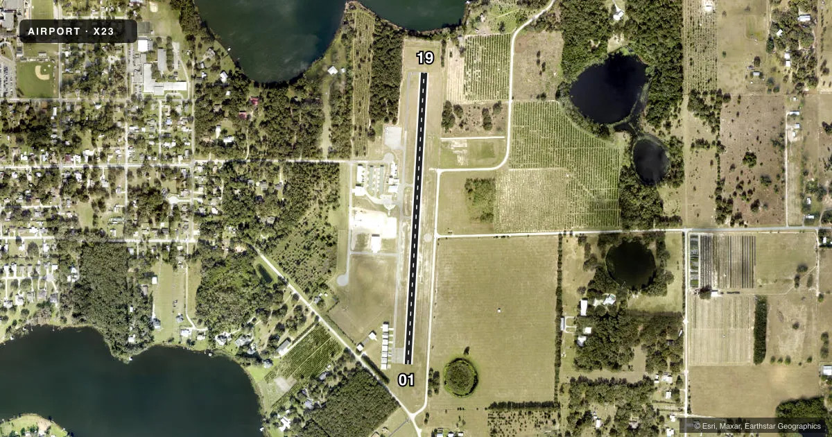
Runways & pattern
Full pagePattern entry · RWY 19
LEFT TRAFFICRunway end performance
| End | TORA | TODA | ASDA | LDA | VGSI | Approach lights | Obstruction |
|---|---|---|---|---|---|---|---|
| 01 | — | — | — | — | PAPI 2-box right(3.5°) | — | 37', trees, 380' from thr, 125' R of cntrln, slope 4 |
| 19 | — | — | — | — | PAPI 2-box left(3.5°) | — | 16', brush, 340' from thr, 30' R of cntrln, slope 8 |
Declared distances in feet. TORA = takeoff run available, TODA = takeoff distance, ASDA = accelerate-stop, LDA = landing distance.
Airport sketch
Runways drawn to scale from FAA survey coordinates, rendered over satellite imagery. Not for navigation.
Approaches & charts
Services on the field
Fuel grades, oxygen, maintenance, ramp storage and lighting — as declared to the FAA by the airport operator.
Fuel & services
- Fuel
- 100100LL
- Oxygen (bottled)
- Not available
- Oxygen (bulk)
- Not available
- Airframe repair
- Not available
- Power plant repair
- Not available
- Other services
- INSTR
Ramp & ground
- Transient storage
- Tie-down
- Landing fee
- No fee published
- Customs
- Not available
- Lighting schedule
- SEE RMK
- Beacon schedule
- SS-SR
- Beacon
- White / Green (civil land)(WG)
- Wind indicator
- Lighted
Fuel & FBOs
Cheapest 100LL and Jet A on the field and nearby. Always confirm with the FBO before taxi.
Airport notes
Surface conditions, obstructions, local procedures, lighting outages and other notes published with each FAA cycle.
General notes
- FOR CD OR TO CNL IFR CTC ORLANDO APCH AT 407-852-7500.
- UNLGTD OBSTRUCTIONS IN THE APPRCH TO RWY 01 DUE TO TREES 380 FT BFR AER.
Lighting notes
- ACTVT PAPI RWY 01 & 19; MIRL RWY 01/19- CTAF.
Approach & departure obstructions
- 01RWY 01 APCH SLP 16:1 TO DTHR.
- 19RWY 19 APCH SLP 24:1 TO DTHR.
Other notes
- EXISTED PRIOR TO 1959.
- MANAGERAIRPORT PHYSICAL ADDRESS: 1 UMATILLA AIRPORT WAY, UMATILLA, FL 32784
VFR map & nearby airports
VFR sectional. Tap any ICAO chip to open that airport.
Key facts · X23
Answer card- ICAO
- X23
- Name
- UMATILLA MUNI
- Location
- UMATILLA, FLORIDA
- Elevation
- 106 ft MSL
- Traffic pattern altitude
- 1,106 ft MSL (1,000 AGL)
- Control tower
- Non-towered (use CTAF)
- Total runways
- 1
- Longest runway
- 01/19 · 2,876 ft
- Published ILS approaches
- 0
- Published frequencies
- 3
- Magnetic variation
- 6°
- Current flight rules
- VFR
- Current wind
- 220° at 6 kt
- Favored runway now
- RWY 19
Umatilla Muni sits in Umatilla, Florida at 106 ft MSL. It has one asphalt runway, 01/19, at 2,876 ft. There is no control tower. CTAF is 122.9. Orlando Approach and departure are listed on 135.3 and 351.9. No ILS approaches are published here.
The pattern altitude is not published. Use the standard 1,000 ft AGL unless the current Chart Supplement says otherwise. The field is a simple setup for light piston traffic. The on-field FBO is Umatilla Municipal Airport. It carries 100LL. Call (352) 669-2290 before arrival if you need current service details.
A few remarks matter on a first visit. Runway 01 has trees in the approach path. The published slope to the displaced threshold is steep. Runway 19 also has a steep published approach slope to the displaced threshold. PAPI and medium intensity runway lights are activated by CTAF. If you need clearance delivery or IFR cancellation, Orlando Approach handles that. The airport sits in central Florida, so expect normal warm-weather density altitude planning in the summer. Check the current Chart Supplement for any noise or operating notes before you go.