METAR & TAF 2J8
2J8 does not publish a METAR.
Showing the nearest reporting station: KDED (DELAND MUNI-SIDNEY H TAYLOR FLD) · 14.3 NM away. Conditions at 2J8 may differ.
METAR · KDED
Observed 13:10Z
KDED 271310Z AUTO 26006KT 10SM CLR 26/25 A2992 RMK AO2 LTG DSNT SW T02620254
- Wind
- 260° @ 6 kt
- Visibility
- 10 SM
- Temp / Dew
- 26°C / 25°C
- Altimeter
- 29.92 inHg
- Clouds
- CLR
- Density alt
- 1,398 ft
- Ceiling
- Unlimited
- Rules
- VFR
Airport info & contacts
Manager on record, flight service, ARTCC, attendance schedule and pattern altitude — published by the FAA and refreshed every 28 days.
Location
- From city
- 1 NM N
- VFR sectional
- JACKSONVILLE
- ARTCC
- ZJX · JACKSONVILLE
- NOTAM facility
- PIE (NOTAM-D)
Airport manager
- Name
- GRAY LEONHARD
- Phone
- 386-749-2661
- Address
- 106 N CENTER ST, PIERSON FL 32180
Flight service · Hours
- FSS PIE
- SAINT PETERSBURG1-800-WX-BRIEF
- Attendance
- Unattended
Frequencies
Tap any row to copy the frequency to your clipboard.
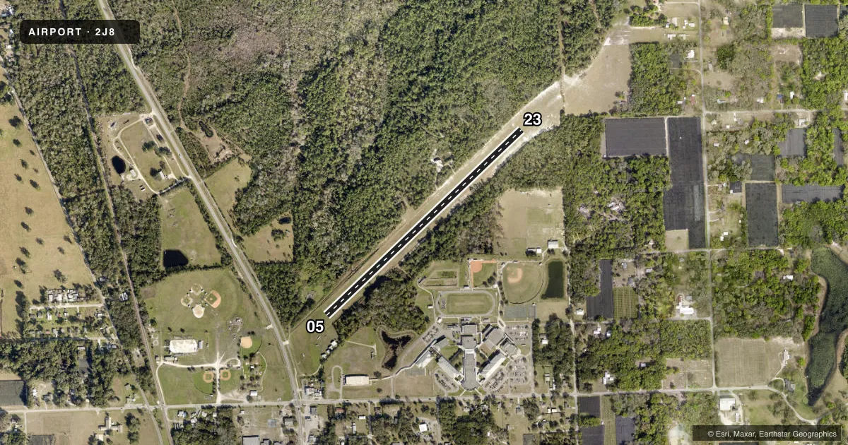
Runways & pattern
Full pagePattern entry · RWY 23
RIGHT TRAFFICRunway end performance
| End | TORA | TODA | ASDA | LDA | VGSI | Approach lights | Obstruction |
|---|---|---|---|---|---|---|---|
| 05 | — | — | — | — | — | — | 62', pole, 1240' from thr, 105' R of cntrln, slope 20 |
| 23 | — | — | — | — | — | — | 42', trees, 830' from thr, 62' R of cntrln, slope 20 |
Declared distances in feet. TORA = takeoff run available, TODA = takeoff distance, ASDA = accelerate-stop, LDA = landing distance.
Airport sketch
Runways drawn to scale from FAA survey coordinates, rendered over satellite imagery. Not for navigation.
Approaches & charts
Services on the field
Fuel grades, oxygen, maintenance, ramp storage and lighting — as declared to the FAA by the airport operator.
Fuel & services
- Fuel
- Not available
- Oxygen (bottled)
- Not available
- Oxygen (bulk)
- Not available
- Airframe repair
- Minor
- Power plant repair
- Minor
- Other services
- GLD,INSTR,TOW
Ramp & ground
- Transient storage
- Tie-down
- Landing fee
- No fee published
- Wind indicator
- Yes
- Segmented circle
- No
Fuel & FBOs
Cheapest 100LL and Jet A on the field and nearby. Always confirm with the FBO before taxi.
Airport notes
Surface conditions, obstructions, local procedures, lighting outages and other notes published with each FAA cycle.
General notes
- 30 FT TREES + OR - 125 FT FM CNTRLN FULL LEN RWY 05/23.
- FOR CD OR TO CNL IFR CTC DAB APCH AT 386-226-3939.
Approach & departure obstructions
- 05BNDRY MARKERS (SINGLE YELLOW CONES) EVERY 200'.
- 23BDRY MKRS (SNGL YELLOW CONES) EV 200 FT.
- 0595 FT ANT 1900 FT FM RY END.
Other notes
- EXISTED PRIOR TO 1959.
- 05/23USE CNTR 60 FT OF RWY DUE TO ROUGH RIDE ON OUTER EDGES. RWY SOFT & WET AFTER HEAVY RAIN EVENTS.
VFR map & nearby airports
VFR sectional. Tap any ICAO chip to open that airport.
Key facts · 2J8
Answer card- ICAO
- 2J8
- Name
- PIERSON MUNI
- Location
- PIERSON, FLORIDA
- Elevation
- 63 ft MSL
- Traffic pattern altitude
- 1,063 ft MSL (1,000 AGL)
- Control tower
- Non-towered (use CTAF)
- Total runways
- 1
- Longest runway
- 05/23 · 2,600 ft
- Published ILS approaches
- 0
- Published frequencies
- 1
- Magnetic variation
- 3°
- Current flight rules
- VFR
- Current wind
- 260° at 6 kt
- Favored runway now
- RWY 23
Pierson Muni is in Pierson, Florida. The field elevation is 63 ft MSL. It has one runway. Runway 05/23 is 2,600 ft of turf, so plan for soft-field technique and a longer landing roll than you would expect on pavement. There is no control tower. CTAF is 122.9. No ILS approaches are published here.
The published pattern altitude is not listed, so use the standard 1,000 ft AGL for light piston operations unless the current FAA Chart Supplement says otherwise. The airport sits in a low-elevation area in north Florida. That means weather and surface conditions matter more than altitude performance, but the runway can still get soft after heavy rain. The Chart Supplement notes boundary markers made of yellow cones on both ends of the runway. It also says to use the center 60 feet because the outer edges ride rough. There are 30-foot trees near the runway centerline along the full length of 05/23. A 95-foot antenna sits about 1,900 feet from the runway end on the 05 side. There are no on-field FBOs listed, so verify services with the airport operator or call the field directly before you go. For IFR clearance delivery or IFR cancel, contact DAB Approach at 386-226-3939.