METAR & TAF KOMN
Current METAR
Observed 14:50Z
KOMN 271450Z 30006KT 7SM SCT023 BKN028 32/28 A2989
- Wind
- 300° @ 6 kt
- Visibility
- 7 SM
- Temp / Dew
- 32°C / 28°C
- Altimeter
- 29.89 inHg
- Clouds
- BKN
- Density alt
- 2,112 ft
- Ceiling
- 2,800 ft AGL
- Rules
- MVFR
Airport info & contacts
Manager on record, flight service, ARTCC, attendance schedule and pattern altitude — published by the FAA and refreshed every 28 days.
Location
- From city
- 3 NM NW
- VFR sectional
- JACKSONVILLE
- ARTCC
- ZJX · JACKSONVILLE
- NOTAM facility
- OMN (NOTAM-D)
Airport manager
- Name
- BRIAN RADEMACHER
- Phone
- 386-676-3266
- Address
- P.O. BOX 277, ORMOND BEACH FL 32175-8406
Flight service · Hours
- FSS PIE
- SAINT PETERSBURG1-800-WX-BRIEF
- Attendance
- 0700-1900
Frequencies
Tap any row to copy the frequency to your clipboard.
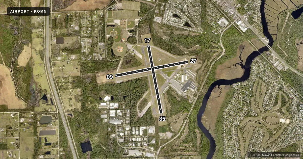
Runways & pattern
Full pagePattern entry · RWY 27
RIGHT TRAFFIC| Runway | Heading (°M) | Length | Surface | Traffic |
|---|---|---|---|---|
| 09/27Favored | 73° / 253° | 4,005 ft | ASPH | 27 R |
| 17/35 | 163° / 343° | 3,704 ft | ASPH | 17 R |
Runway end performance
| End | TORA | TODA | ASDA | LDA | VGSI | Approach lights | Obstruction |
|---|---|---|---|---|---|---|---|
| 09 | — | — | — | — | PAPI 4-box left(3.4°) | — | 8', brush, 250' from thr, 250' R of cntrln, slope 6 |
| 27 | — | — | — | — | PAPI 4-box left(3.4°) | — | 23', trees, 545' from thr, 100' R of cntrln, slope 15 |
| 17 | — | — | — | — | PAPI 4-box left(3.5°) | — | 60', trees, 1200' from thr, 30' R of cntrln, slope 16 |
| 35 | — | — | — | — | PAPI 4-box left(3°) | — | 34', trees, 720' from thr, 17' R of cntrln, slope 15 |
Declared distances in feet. TORA = takeoff run available, TODA = takeoff distance, ASDA = accelerate-stop, LDA = landing distance.
Airport sketch
Runways drawn to scale from FAA survey coordinates, rendered over satellite imagery. Not for navigation.
Approaches & charts
Services on the field
Fuel grades, oxygen, maintenance, ramp storage and lighting — as declared to the FAA by the airport operator.
Fuel & services
- Fuel
- 100LLA
- Oxygen (bottled)
- Not available
- Airframe repair
- Major
- Power plant repair
- Major
- Other services
- CHTR,INSTR,RNTL,SALES,SURV
Ramp & ground
- Transient storage
- Tie-down
- Landing fee
- No fee published
- Customs
- Not available
- Lighting schedule
- SEE RMK
- Beacon schedule
- SS-SR
- Beacon
- White / Green (civil land)(WG)
- Wind indicator
- Lighted
Fuel & FBOs
Cheapest 100LL and Jet A on the field and nearby. Always confirm with the FBO before taxi.
Airport notes
Surface conditions, obstructions, local procedures, lighting outages and other notes published with each FAA cycle.
General notes
- TWY PTNS CRACKED WITH GRASS.
- NOISE ABATEMENT PROC IN EFCT - 386-615-7019.
- PRIM SFCS 500 FT WIDE WITH 7:1 TRSN SFC ON SIDES; TREES IN ALL TRSN SFCS AT APCH END.
- LINE OF SIGHT OBSTN BTN RWY 09/27 AND RWY 17/35.
- DEER ON & INVOF ARPT.
- FOR CD OR TO CNL IFR WHEN ATCT IS CLSD CTC DAB APCH AT 386-226-3939.
Lighting notes
- ACTVT REIL RWY 09, 17, 27, & 35; PAPI RWY 09, 17, 27, & 35; MIRL RWYS 09/27 & 17/35 - CTAF.
Approach & departure obstructions
- 09UNLGTD OBSTNS IN APCH; 52 FT TREES 1245 FT BFR AER.
- 17UNLGTD OBSTNS IN APCH; 50 FT TREES 1200 FT BFR AER.
- 27UNLGTD OBSTNS IN APCH; 43 FT TREES 840 FT BFR AER.
- 17RWY 17 MARKINGS DISCOLORED AND IN POOR COND.
- 35RWY 35 MARKINGS DISCOLORED AND IN POOR COND.
- 09APCH SLP 14:1 TO AER. APCH SLP 20:1 TO AER.
- 17APCH SLP 20:1 TO AER. APCH SLP 21:1 TO AER.
Other notes
- MANAGERARPT PHYS ADS: 770 ARPT RD. ORMOND BEACH, FL 32174. 386-676-3267
- OWNERCTC PERSON: JOYCE SHANAHAN 386-676-3200
VFR map & nearby airports
VFR sectional. Tap any ICAO chip to open that airport.
Key facts · KOMN
Answer card- ICAO
- KOMN
- Name
- ORMOND BEACH MUNI
- Location
- ORMOND BEACH, FLORIDA
- Elevation
- 28.1 ft MSL
- Traffic pattern altitude
- 1,028.1 ft MSL (1,000 AGL)
- Control tower
- Towered · 0700-1900
- Total runways
- 2
- Longest runway
- 09/27 · 4,005 ft
- Published ILS approaches
- 0
- Published frequencies
- 10
- Magnetic variation
- 6°
- Current flight rules
- MVFR
- Current wind
- 300° at 6 kt
- Favored runway now
- RWY 27
Ormond Beach Muni sits in Ormond Beach, Florida. The field elevation is 28.1 ft MSL. It has two asphalt runways. The longest is 4,005 ft on runway 09/27. The tower is open from 0700 to 1900. Outside those hours, plan on CTAF use and verify current procedures before arrival.
No ILS approaches are published here. The pattern altitude is not published in the facts, so use the standard 1,000 ft AGL for light piston traffic unless the current Chart Supplement says otherwise. Sunrise Aviation is on the field. It carries 100LL and Jet A. Call ahead if you need fuel or ramp details.
This is a busy controlled field with Daytona Class C services nearby on 125.8 and 269.075. Noise abatement procedures are in effect, so get the current guidance before you launch. The published remarks also note trees in the transitional surfaces at the approach end. There is a line of sight obstruction between the two runways. Runway 17 and runway 35 have discolored markings. Runway 09 and runway 27 also have unlighted obstructions in the approach. If you are new to the airport, study the runway layout and the approach environment before you go in.