METAR & TAF KEVB
Current METAR
Observed 01:47Z
KEVB 270147Z 20004KT 10SM OVC045 26/26 A2994 RMK LAST
- Wind
- 200° @ 4 kt
- Visibility
- 10 SM
- Temp / Dew
- 26°C / 26°C
- Altimeter
- 29.94 inHg
- Clouds
- OVC
- Density alt
- 1,309 ft
- Ceiling
- 4,500 ft AGL
- Rules
- VFR
Airport info & contacts
Manager on record, flight service, ARTCC, attendance schedule and pattern altitude — published by the FAA and refreshed every 28 days.
Location
- From city
- 3 NM NW
- VFR sectional
- JACKSONVILLE
- Pattern altitude
- 788 ft AGL · 799 ft MSL
- ARTCC
- ZJX · JACKSONVILLE
- NOTAM facility
- EVB (NOTAM-D)
Airport manager
- Name
- ARVIN WEESE
- Phone
- 386-410-2680
- Address
- NEW SMYRNA BEACH MUNI AIRPORT, 602 SKYLINE DRIVE, NEW SMYRNA BEACH FL 32168
Flight service · Hours
- FSS PIE
- SAINT PETERSBURG1-800-WX-BRIEF
- Attendance
- 0700-1800
Frequencies
Tap any row to copy the frequency to your clipboard.
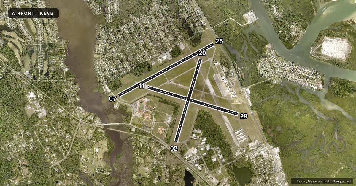
Runways & pattern
Full pagePattern entry · RWY 20
LEFT TRAFFIC| Runway | Heading (°M) | Length | Surface | Traffic |
|---|---|---|---|---|
| 07/25 | 58° / 238° | 5,000 ft | ASPH | Standard L |
| 11/29 | 103° / 283° | 4,319 ft | ASPH | Standard L |
| 02/20Favored | 13° / 193° | 4,000 ft | ASPH | Standard L |
Runway end performance
| End | TORA | TODA | ASDA | LDA | VGSI | Approach lights | Obstruction |
|---|---|---|---|---|---|---|---|
| 07 | 5,000' | 5,000' | 4,853' | 4,518' | PAPI 4-box left(3°) | — | 15', road, 201' from thr, 250' R of cntrln, slope 0 |
| 25 | 5,000' | 5,000' | 4,763' | 4,463' | PAPI 4-box left(3°) | — | 6', fence, 201' from thr, 250' R of cntrln, slope 0 |
| 11 | — | — | — | — | PAPI 4-box left(3.5°) | — | 78', trees, 1780' from thr, 200' R of cntrln, slope 20 |
| 29 | — | — | — | — | PAPI 4-box left(3°) | — | 15', road, 537' from thr, 250' R of cntrln, slope 21 |
| 02 | 4,000' | 4,000' | 4,000' | 3,215' | — | — | 16', road, 295' from thr, 250' R of cntrln, slope 5 |
| 20 | 4,000' | 4,000' | 3,952' | 3,952' | — | — | 55', trees, 1390' from thr, 250' R of cntrln, slope 21 |
Declared distances in feet. TORA = takeoff run available, TODA = takeoff distance, ASDA = accelerate-stop, LDA = landing distance.
Airport sketch
Runways drawn to scale from FAA survey coordinates, rendered over satellite imagery. Not for navigation.
Approaches & charts
Services on the field
Fuel grades, oxygen, maintenance, ramp storage and lighting — as declared to the FAA by the airport operator.
Fuel & services
- Fuel
- 100LLA
- Oxygen (bottled)
- Not available
- Oxygen (bulk)
- Not available
- Airframe repair
- Major
- Power plant repair
- Major
- Other services
- AVNCS,CHTR,INSTR,RNTL,SALES
Ramp & ground
- Transient storage
- Tie-down
- Landing fee
- No fee published
- Customs
- Not available
- Lighting schedule
- SEE RMK
- Beacon schedule
- SS-SR
- Beacon
- White / Green (civil land)(WG)
- Wind indicator
- Lighted
Fuel & FBOs
Cheapest 100LL and Jet A on the field and nearby. Always confirm with the FBO before taxi.
Airport notes
Surface conditions, obstructions, local procedures, lighting outages and other notes published with each FAA cycle.
General notes
- VOLUNTARY NOISE ABATEMENT IN EFCT, CTC ARPT MGR FOR DETAILS AT 386-410-2680.
- BIRDS ON & INVOF ARPT.
- ARPT CLSD FOR ULTRALIGHTS, EXC PPR 386-410-2680.
- FOR CD OR TO CNL IFR WHEN ATCT IS CLSD CTC DAB APCH AT 386-226-3939.
- UNLGTD FENCE 174 FT BFR AER 07, 250 FT RIGHT OF CNTRLN.
- ALL HELO OPS EXPC FULL SVC FUEL ONLY, SELF SVC CLSD TO ALL ROTARY WING ACFT.
- 24 HR PPR FOR ACFT EQUIPPED WITH WEATHER MODIFICATION OR GEOENGINEERING EQPT 386-410-2680.
- MAIN RAMP RSTRD TO ACFT WITH WINGSPAN LESS THAN 79 FT WO PPR. CALL AIRFIELD OPS 24 HR PRIOR 386-410-2680.
- RWY 07 OR RWY 11 DSGND CALM WIND RWY IN VFR COND
Lighting notes
- ACTVT MIRL RWY 11/29 & 07/25 AFTER 2300 - CTAF.
Fuel notes
- ASELF SVC JET-A INCLS ANTI-ICING ADDITIVE
Approach & departure obstructions
- 07RWY 07 6 FT FENCE 174 FT FM AER, 250 FT R.
- 02RWY 02 APCH RATIO 34:1 TO DSPLCD THR.
- 07RWY 07 APCH RATIO 34:1 TO DSPLCD THR.
- 25RWY 25 APCH RATIO 34:1 TO DSPLCD THR.
Other notes
- TPA FOR LGT ACFT 788 FT AGL, HVY ACFT 1188 FT AGL.
- 02/20RWY 02/20 LONGL & TRANSVERSE CRACKING THRUT W/ GRASS.
VFR map & nearby airports
VFR sectional. Tap any ICAO chip to open that airport.
Key facts · KEVB
Answer card- ICAO
- KEVB
- Name
- NEW SMYRNA BEACH MUNI (JACK BOLT FLD)
- Location
- NEW SMYRNA BEACH, FLORIDA
- Elevation
- 10.8 ft MSL
- Traffic pattern altitude
- 798.8 ft MSL (788 AGL)
- Control tower
- Towered · 0700-2200
- Total runways
- 3
- Longest runway
- 07/25 · 5,000 ft
- Published ILS approaches
- 0
- Published frequencies
- 7
- Magnetic variation
- 4°
- Current flight rules
- VFR
- Current wind
- 200° at 4 kt
- Favored runway now
- RWY 20
New Smyrna Beach Muni (Jack Bolt Fld) sits in New Smyrna Beach, Florida. Field elevation is 10.8 ft MSL. The airport has three asphalt runways. The longest is runway 07/25 at 5,000 ft. The field is towered from 0700 to 2200. No ILS approaches are published here, so plan on visual or non-ILS instrument procedures as available on the current chart. Pattern altitude is 788 ft AGL. That is 798.8 ft MSL.
The on-field FBOs are Epic Flight Academy, New Smyrna Beach Municipal Airport and Airgate Aviation. Epic Flight Academy carries 100LL. New Smyrna Beach Municipal Airport carries 100LL and Jet A. Airgate Aviation carries 100LL and Jet A. If you are bringing a larger aircraft, note the main ramp is restricted to wingspans under 79 ft without prior permission. Call airfield operations 24 hours ahead at 386-410-2680.
A few operational items matter here. Runway 02/20 has cracking and grass reported along the surface. There is also an unlighted fence near the approach to runway 07. Birds are reported on and near the airport. Helicopter operations are full-service fuel only. Self-service is closed to rotary wing aircraft. Check the current FAA Chart Supplement before you go. That is the best place to confirm any current restrictions or changes.