METAR & TAF F15
F15 does not publish a METAR.
Showing the nearest reporting station: KDAB (DAYTONA BEACH INTL) · 4.0 NM away. Conditions at F15 may differ.
METAR · KDAB
Observed 14:53Z
KDAB 271453Z 27006KT 10SM SCT019 BKN250 30/26 A2989 RMK AO2 SLP122 T03000256 56005
- Wind
- 270° @ 6 kt
- Visibility
- 10 SM
- Temp / Dew
- 30°C / 26°C
- Altimeter
- 29.89 inHg
- Clouds
- BKN
- Density alt
- 1,843 ft
- Ceiling
- 25,000 ft AGL
- Rules
- VFR
Airport info & contacts
Manager on record, flight service, ARTCC, attendance schedule and pattern altitude — published by the FAA and refreshed every 28 days.
Location
- From city
- 0 NM N
- VFR sectional
- JACKSONVILLE
- ARTCC
- ZJX · JACKSONVILLE
- NOTAM facility
- PIE (NOTAM-D)
Airport manager
- Name
- CHRISTOPHER 'DOC' BAILEY
- Phone
- 314-322-5660
- Address
- 265 GEORGETOWN SHORTCUT RD, CRESCENT CITY FL 32112
Flight service · Hours
- FSS PIE
- SAINT PETERSBURG1-800-WX-BRIEF
- Attendance
- Unattended
Frequencies
Tap any row to copy the frequency to your clipboard.
Runways & pattern
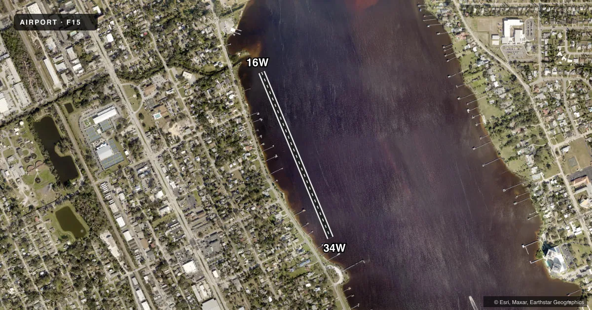
Full pagePattern entry · RWY 34W
RIGHT TRAFFICAirport sketch
Runways drawn to scale from FAA survey coordinates, rendered over satellite imagery. Not for navigation.
Approaches & charts
Services on the field
Fuel grades, oxygen, maintenance, ramp storage and lighting — as declared to the FAA by the airport operator.
Fuel & services
- Fuel
- Not available
- Oxygen (bottled)
- Not available
- Oxygen (bulk)
- Not available
- Airframe repair
- Not available
- Power plant repair
- Not available
Ramp & ground
- Transient storage
- Not published
- Landing fee
- No fee published
- Wind indicator
- Yes
Fuel & FBOs
Cheapest 100LL and Jet A on the field and nearby. Always confirm with the FBO before taxi.
Airport notes
Surface conditions, obstructions, local procedures, lighting outages and other notes published with each FAA cycle.
General notes
- CONTACT CHRISTOPHER "DOC" BAILEY 386 414 1448 FOR MORE INFORMATION REGARDING POSSIBLE RESTRICTIONS.
- FOR CD CTC DAYTONA APCH AT 386-226-3912 OR 386-226-3939.
Other notes
- SEE AIRSPACE CASE 2016-ASO-3601-NRA
- PVT OWNED SPB, BUT FOR PUB USE. RMN WI 300 FT OF THE SHORELINE TO BE WI THE JURISDICTION OF THE MANATEE SPEED LIMIT VARIANCE.
- MANAGERAIRPORT PHYSICAL ADDRESS: 1125 RIVERSIDE DR, HOLLY HILL, FL 32117
VFR map & nearby airports
VFR sectional. Tap any ICAO chip to open that airport.
Key facts · F15
Answer card- ICAO
- F15
- Name
- HALIFAX RIVER
- Location
- HOLLY HILL, FLORIDA
- Elevation
- 5 ft MSL
- Traffic pattern altitude
- 1,005 ft MSL (1,000 AGL)
- Control tower
- Non-towered (use CTAF)
- Total runways
- 1
- Longest runway
- 16W/34W · 2,500 ft
- Published ILS approaches
- 0
- Published frequencies
- 1
- Magnetic variation
- –
- Current flight rules
- VFR
- Current wind
- 270° at 6 kt
- Favored runway now
- RWY 34W
Halifax River (F15) sits in Holly Hill, Florida. The field elevation is 5 ft MSL. It is a public-use seaplane base with one water runway, 16W/34W, at 2,500 ft. There is no control tower. CTAF is 122.9.
No ILS approaches are published here. Pattern altitude is not published, so use the standard 1,000 ft AGL for light piston operations unless the current Chart Supplement says otherwise. The airport is a water landing area, so plan for shoreline, boat traffic and surface conditions before you arrive. The published remarks also say to stay within 300 feet of the shoreline to remain within the manatee speed limit variance area. That matters here.
There are no on-field FBOs listed in the facts. Contact the airport operator directly or call the field on CTAF for current service availability. The published remarks also point pilots to Daytona Approach for clearance delivery. They list a contact for more information on possible restrictions. The airport physical address is 1125 Riverside Drive, Holly Hill, Florida 32117. Check the current FAA Chart Supplement for the latest airspace notes and any operating restrictions before you go.