METAR & TAF KDED
Current METAR
Observed 12:50Z
KDED 271250Z AUTO 26005KT 10SM SCT027 26/25 A2992 RMK AO2 LTG DSNT SW T02610254
- Wind
- 260° @ 5 kt
- Visibility
- 10 SM
- Temp / Dew
- 26°C / 25°C
- Altimeter
- 29.92 inHg
- Clouds
- SCT
- Density alt
- 1,418 ft
- Ceiling
- Unlimited
- Rules
- VFR
Airport info & contacts
Manager on record, flight service, ARTCC, attendance schedule and pattern altitude — published by the FAA and refreshed every 28 days.
Location
- From city
- 3 NM NE
- VFR sectional
- JACKSONVILLE
- ARTCC
- ZJX · JACKSONVILLE
- NOTAM facility
- PIE (NOTAM-D)
Airport manager
- Name
- JOHN EIFF
- Phone
- 386-626-7240
- Address
- 1000 FLIGHTLINE BLVD, DELAND FL 32724
Flight service · Hours
- FSS PIE
- SAINT PETERSBURG1-800-WX-BRIEF
- Attendance
- MON-FRI · 0800-1800
- SAT-SUN · 0900-1700
Frequencies
Tap any row to copy the frequency to your clipboard.
Runways & pattern
Full pagePattern entry · RWY 23
LEFT TRAFFIC| Runway | Heading (°M) | Length | Surface | Traffic |
|---|---|---|---|---|
| 12/30 | 112° / 292° | 6,001 ft | ASPH | Standard L |
| 05/23Favored | 43° / 223° | 4,301 ft | ASPH | Standard L |
Runway end performance
| End | TORA | TODA | ASDA | LDA | VGSI | Approach lights | Obstruction |
|---|---|---|---|---|---|---|---|
| 12 | — | — | — | — | PAPI 2-box left(3°) | — | 26', trees, 1105' from thr, 75' R of cntrln, slope 34 |
| 30 | — | — | — | — | PAPI 4-box left(3°) | — | 66', trees, 2220' from thr, 235' R of cntrln, slope 30 |
| 05 | — | — | — | — | PAPI 2-box left(3°) | — | 50', trees, 1455' from thr, 230' R of cntrln, slope 25 |
| 23 | — | — | — | — | PAPI 2-box left(3°) | — | 54', trees, 2055' from thr, 200' R of cntrln, slope 34 |
Declared distances in feet. TORA = takeoff run available, TODA = takeoff distance, ASDA = accelerate-stop, LDA = landing distance.
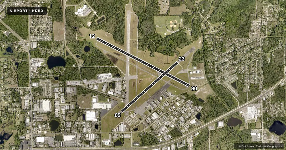
Airport sketch
Runways drawn to scale from FAA survey coordinates, rendered over satellite imagery. Not for navigation.
Approaches & charts
Services on the field
Fuel grades, oxygen, maintenance, ramp storage and lighting — as declared to the FAA by the airport operator.
Fuel & services
- Fuel
- 100LLAUL94
- Oxygen (bottled)
- Not available
- Oxygen (bulk)
- Not available
- Airframe repair
- Major
- Power plant repair
- Major
- Other services
- AVNCS,INSTR,PAJA,RNTL
Ramp & ground
- Transient storage
- Tie-down
- Hangar
- Landing fee
- No fee published
- Customs
- Not available
- Lighting schedule
- SEE RMK
- Beacon schedule
- SS-SR
- Beacon
- White / Green (civil land)(WG)
- Wind indicator
- Lighted
Fuel & FBOs
Cheapest 100LL and Jet A on the field and nearby. Always confirm with the FBO before taxi.
Airport notes
Surface conditions, obstructions, local procedures, lighting outages and other notes published with each FAA cycle.
General notes
- TOUCH & GO OPNS PROHIBITED IF THERE ARE 3 OR MORE ACFT IN THE TFC PATTERN.
- NOISE ABATEMENT PROCEDURES IN EFFECT, CALL AMGR (386) 740-6955.
- EXTSV PARACHUTE & FLT TRNG OPNS. AVOID OVER FLYING ARPT DURG PARACHUTE OPNS.
- NOISE SENSITIVE ARPT. AVOID OVER FLT OF RESIDENTIAL AREA S OF ARPT; AVOID WIDE DOWNWIND RY 23. JET ACFT USE NBAA NOISE ABATEMENT PROCEDURES.
- CALM WIND RY 05.
- LMTD SIGHT DISTANCES ALL RYS.
- CTC UNICOM FOR TIE DOWN INFO.
- FOR CD OR TO CNL IFR CTC DAYTONA APCH AT 386-226-3939.
- UNLIGTD OBSTNS IN THE APCH TO RWY 05 DUE TO TREES 51 FT TALL 1455 FT BFR AER.
Lighting notes
- ACTVT REIL RWY 12 & 30; PAPI RWY 30; MIRL RWY 05/23, HIRL RWY 12/30 - CTAF. PAPI RWY 05, 12, & 23 OPER CONSLY.
Fuel notes
- 100LLSELF SERVE 100LL AVBL 24 HRS WITH CREDIT CARD.
Approach & departure obstructions
- 05RWY 05 MRKGS FADED & DISCOLORED.
- 12RWY 12 MRKGS FADED & DISCOLORED.
- 23RWY 23 MRKGS FADED & DISCOLORED.
- 30RWY 30 MRKGS FADED & DISCOLORED.
Other notes
- MANAGERARPT PHYS ADS: 1000 FLIGHTLINE BLVD.
VFR map & nearby airports
VFR sectional. Tap any ICAO chip to open that airport.
Key facts · KDED
Answer card- ICAO
- KDED
- Name
- DELAND MUNI-SIDNEY H TAYLOR FLD
- Location
- DELAND, FLORIDA
- Elevation
- 79.2 ft MSL
- Traffic pattern altitude
- 1,079.2 ft MSL (1,000 AGL)
- Control tower
- Non-towered (use CTAF)
- Total runways
- 2
- Longest runway
- 12/30 · 6,001 ft
- Published ILS approaches
- 0
- Published frequencies
- 4
- Magnetic variation
- 5°
- Current flight rules
- VFR
- Current wind
- 260° at 5 kt
- Favored runway now
- RWY 23
DeLand Muni-Sidney H Taylor Fld (KDED) sits in DeLand, Florida at 79.2 ft MSL. It has two asphalt runways. The longest is 12/30 at 6,001 ft. There is no control tower, so expect CTAF and UNICOM self-announce traffic. Daytona Approach and Departure are listed on 125.35 and 322.3. No ILS approaches are published.
Pattern altitude is not published. Use the standard 1,000 ft AGL for light piston traffic unless the current Chart Supplement says otherwise. The field is busy with parachute and flight training activity. Avoid overflying the airport during parachute operations. This is also a noise-sensitive airport. Avoid the residential area south of the field. Avoid a wide downwind for runway 23. Jet traffic is expected to use NBAA noise abatement procedures.
DeLand Aviation is on the field. It carries 100LL, Jet A and UL94. Self-serve 100LL is available 24 hours with credit card. Runway 30 markings are faded and discolored. Runway 23 markings are also faded and discolored. Runway 12 markings are faded and discolored. Runway 05 has trees 1,455 ft before the airport on final. If you need tie-down information, contact UNICOM. The airport physical address is 1000 Flightline Boulevard.