METAR & TAF KDAB
Current METAR
Observed 13:18Z
KDAB 271318Z 20006KT 9SM FEW008 SCT029 BKN039 BKN250 27/26 A2991 RMK AO2 T02720256
- Wind
- 200° @ 6 kt
- Visibility
- 9 SM
- Temp / Dew
- 27°C / 26°C
- Altimeter
- 29.91 inHg
- Clouds
- BKN
- Density alt
- 1,495 ft
- Ceiling
- 3,900 ft AGL
- Rules
- VFR
Airport info & contacts
Manager on record, flight service, ARTCC, attendance schedule and pattern altitude — published by the FAA and refreshed every 28 days.
Location
- From city
- 3 NM SW
- VFR sectional
- JACKSONVILLE
- Pattern altitude
- 965 ft AGL · 999 ft MSL
- ARTCC
- ZJX · JACKSONVILLE
- NOTAM facility
- DAB (NOTAM-D)
Airport manager
- Name
- MS KAREN K FEASTER, AAE, IACE, ACE
- Phone
- 386-248-8030
- Address
- 700 CATALINA DR, SUITE 300, DAYTONA BEACH INTL ARPT, DAYTONA BEACH FL 32114
Flight service · Hours
- FSS PIE
- SAINT PETERSBURG1-800-WX-BRIEF
- Attendance
- ALL
Frequencies
Tap any row to copy the frequency to your clipboard.
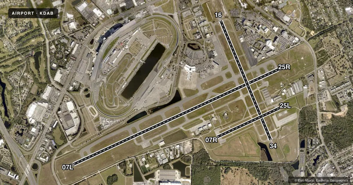
Runways & pattern
Full pagePattern entry · RWY 16
LEFT TRAFFIC| Runway | Heading (°M) | Length | Surface | Traffic |
|---|---|---|---|---|
| 07L/25R | 60° / 240° | 10,500 ft | ASPH-CONC | 25R R |
| 16/34Favored | 152° / 332° | 6,001 ft | ASPH | Standard L |
| 07R/25L | 60° / 240° | 3,195 ft | ASPH | 07R R |
Runway end performance
| End | TORA | TODA | ASDA | LDA | VGSI | Approach lights | Obstruction |
|---|---|---|---|---|---|---|---|
| 07L | 10,500' | 10,500' | 10,500' | 9,810' | — | MALSR | 15', road, 790' from thr, 500' R of cntrln, slope 39 |
| 25R | 10,500' | 10,500' | 10,293' | 10,293' | PAPI 4-box left(3°) | MALSR | 43', trees, 2370' from thr, 230' R of cntrln, slope 50 |
| 16 | 6,001' | 6,001' | 5,969' | 5,969' | PAPI 4-box left(3°) | — | 42', trees, 1630' from thr, 275' R of cntrln, slope 34 |
| 34 | 6,001' | 6,001' | 6,001' | 6,001' | PAPI 4-box left(3°) | — | 46', trees, 1130' from thr, 400' R of cntrln, slope 20 |
| 07R | 3,195' | 3,195' | 3,195' | 3,195' | PAPI 2-box left(3°) | — | 55', trees, 1580' from thr, 185' R of cntrln, slope 25 |
| 25L | 3,195' | 3,195' | 3,195' | 3,195' | PAPI 2-box left(3°) | — | 42', trees, 1485' from thr, 105' R of cntrln, slope 30 |
Declared distances in feet. TORA = takeoff run available, TODA = takeoff distance, ASDA = accelerate-stop, LDA = landing distance.
Airport sketch
Runways drawn to scale from FAA survey coordinates, rendered over satellite imagery. Not for navigation.
Approaches & charts
ILS · 2
Services on the field
Fuel grades, oxygen, maintenance, ramp storage and lighting — as declared to the FAA by the airport operator.
Fuel & services
- Fuel
- 100LLA
- Oxygen (bottled)
- Not available
- Oxygen (bulk)
- High pressure
- Airframe repair
- Major
- Power plant repair
- Major
- Other services
- AFRT,AVNCS,CARGO,CHTR,INSTR,RNTL,SURV
Ramp & ground
- Transient storage
- Tie-down
- Hangar
- Landing fee
- No fee published
- Customs
- Not available
- Lighting schedule
- SS-SR
- Beacon schedule
- SS-SR
- Beacon
- White / Green (civil land)(WG)
- Wind indicator
- Lighted
- Segmented circle
- No
Fuel & FBOs
Cheapest 100LL and Jet A on the field and nearby. Always confirm with the FBO before taxi.
Airport notes
Surface conditions, obstructions, local procedures, lighting outages and other notes published with each FAA cycle.
General notes
- HVY MIGRATORY BIRD ACT ON & INVOF ARPT.
- E END OF TWY S IS NON-MOVEMENT AREA.
- TWY E RSTRD TO 22000 LBS MAX CRTFYD GROSS TKOF WEIGHT; TWY P RSTRD TO 190500 LBS MAX CRTFYD GROSS TKOF WEIGHT.
- TWY "N" N OF RY 7L-25R CAN BE MISTAKEN FOR THE RY & APCH ENVIRONMENT.
- USE CO FLY QUIET PROC OR RCMD NOISE ABATEMENT PROC - AMGR.
- AIRFIELD SFC CONDS ARE NOT MNTD BTN THE HRS OF 0000-0400.
- ROTOR WING HEL MUST GRND TAXI; IF UNABL USE CTN DURG HOVER TAXI.
- US CUSTS RAMP RSTRD GROUP II ACFT OF WINGSPAN 79 FT OR LESS.
- TWY C1 CLSD TO ACFT WINGSPAN MORE THAN 119 FT; TWY W CLSD TO ACFT WINGSPAN MORE THAN 119 FT; TWY W3 CLSD TO ACFT WINGSPAN MORE THAN 79 FT.
- TWY W BTN RWY 16 APCH END & TWY A CLSD TO MIL HEL & HOVER TAXI OPS.
- TWY W BTN TWY A & RWY 16 APCH END CLSD TO ROTARY WING WITH ROTAR SPAN MORE THAN 50 FT EXC 1 HR PPR - 386-527-0657.
- ALL MIL OPS REQ 24 HR. ADVND CDN WITH ARPT OPNS - PPR (386) 527-0657.
- ALL HELO OPS EXPC TWY W BTN TWY A & RWY 16 APCH END CLSD TO ROTARY WING ACFT WITH ROTAR SPAN MORE THAN 50 FT EXC 1 HR. PPR (386) 527-0657.
- INCRD DRONE ACT NE OF ARPT.
- HVY BIRD ACTIVITY OVER LANDFILL LOCATED 3.5NM SW OF THE AIRFIELD.
- PPR FOR DAYTONA BEACH SPEEDWAY LOW APCH OR FLY-OVER. CTC ATC FOR PMSN.
- RWY 07L LEAD-OFF LINES FOR TWY P3 AND TWY P4 FOR GROUP I ACFT ONLY WITH WINGSPAN OF LESS THAN 49 FT.
- WX MOD GEO ENGINEERING ACFT NOTIFY AP OPS 24 HRS PRIOR TO ARR/DEP 386-527-0657.
Runway surface & condition
- 07L/25RPCR VALUE: 650/R/A/W/T
- 07R/25LPCR VALUE: 90/F/C/X/T
- 16/34PCR VALUE: 420/F/A/X/T
- 07R/25LRWY 07R/25L NOT AVBL FOR PART 121/PART 380 OPS WITH SKED PAX CARRYING OPS MORE THAN 9 PAX SEATS AND NON-SKED PAX CARRYING OPS MORE THAN 30 PAX SEATS.
- 07L/25RFIRST 2300 FT RWY 7L CONCRETE ON 50 FT WIDE KEEL SECTION.
Approach & departure obstructions
- 25RPAPI UNUSBL BYD 5 DEG LEFT & RIGHT OF CNTRLN.
- 07LRWY 07L APCH SLP 50:1 TO DSPLCD THR.
Other notes
- TPA FOR LGT ACFT 965 FT AGL; TPA FOR HI PER ACFT 1365 FT AGL.
- 07R/25LOUTER EDGES OF PAVEMENT UNEVEN.
VFR map & nearby airports
VFR sectional. Tap any ICAO chip to open that airport.
Key facts · KDAB
Answer card- ICAO
- KDAB
- Name
- DAYTONA BEACH INTL
- Location
- DAYTONA BEACH, FLORIDA
- Elevation
- 34.2 ft MSL
- Traffic pattern altitude
- 999.2 ft MSL (965 AGL)
- Control tower
- Towered · 24
- Total runways
- 3
- Longest runway
- 07L/25R · 10,500 ft
- Published ILS approaches
- 2
- Published frequencies
- 25
- Magnetic variation
- 5°
- Current flight rules
- VFR
- Current wind
- 200° at 6 kt
- Favored runway now
- RWY 16
Daytona Beach Intl is in Daytona Beach, Florida. Field elevation is 34.2 ft MSL. The airport has 3 runways. The longest is 10,500 ft on 07L/25R. The tower is open 24 hours. There are 2 ILS approaches. They serve runway ends 07L and 25R.
Pattern altitude is 965 ft AGL, which is 999.2 ft MSL. That is the number to brief for traffic work here. The field sits in a busy coastal metro area. Expect to stay sharp on noise abatement. The published remarks say to use company fly quiet procedures or the airport manager’s recommended noise abatement procedures.
On field FBOs are Yelvington Jet Aviation, ATP Jet Center and Sheltair. Yelvington Jet Aviation carries 100LL, Jet A and Jet A Prist. ATP Jet Center carries 100LL and Jet A. Sheltair carries 100LL, Jet A and Jet A Prist. Heavy bird activity is reported over the landfill 3.5 NM southwest of the airfield. That matters on arrival and departure. Pilots should also note the runway and taxiway limits in the Chart Supplement. Taxiway and helicopter restrictions are published here too. Check the current FAA Chart Supplement before you fly if you need the latest operational details.