METAR & TAF KFIN
Current METAR
Observed 11:35Z
KFIN 271135Z AUTO 00000KT 10SM SCT029 26/25 A2990 RMK AO2 T02550250
- Wind
- 000° @ 0 kt
- Visibility
- 10 SM
- Temp / Dew
- 26°C / 25°C
- Altimeter
- 29.90 inHg
- Clouds
- SCT
- Density alt
- 1,386 ft
- Ceiling
- Unlimited
- Rules
- VFR
Airport info & contacts
Manager on record, flight service, ARTCC, attendance schedule and pattern altitude — published by the FAA and refreshed every 28 days.
Location
- From city
- 6 NM S
- VFR sectional
- JACKSONVILLE
- ARTCC
- ZJX · JACKSONVILLE
- NOTAM facility
- FIN (NOTAM-D)
Airport manager
- Name
- ROY SIEGER
- Phone
- 386-313-4220
- Address
- 201 AIRPORT ROAD, PALM COAST FL 32164
Flight service · Hours
- FSS GNV
- GAINESVILLE1-800-WX-BRIEF
- Attendance
- MON-SAT · 0700-1800
- SUN · 0800-1500
Frequencies
Tap any row to copy the frequency to your clipboard.
Runways & pattern
Full pagePattern entry · RWY 11
LEFT TRAFFIC| Runway | Heading (°M) | Length | Surface | Traffic |
|---|---|---|---|---|
| 11/29 | 100° / 280° | 5,500 ft | ASPH | Standard L |
| 06/24 | 49° / 229° | 5,001 ft | ASPH | Standard L |
| 18W/36W | 167° / 347° | 3,001 ft | WATER | Standard L |
Runway end performance
| End | TORA | TODA | ASDA | LDA | VGSI | Approach lights | Obstruction |
|---|---|---|---|---|---|---|---|
| 11 | — | — | — | — | PAPI 4-box left(3°) | — | 55', trees, 2155' from thr, 250' R of cntrln, slope 35 |
| 29 | — | — | — | — | PAPI 4-box left(3°) | — | 69', trees, 2324' from thr, 250' R of cntrln, slope 30 |
| 06 | — | — | — | — | PAPI 4-box left(3°) | — | 84', trees, 3075' from thr, 315' R of cntrln, slope 34 |
| 24 | — | — | — | — | PAPI 4-box left(3°) | — | 56', trees, 1325' from thr, 130' R of cntrln, slope 20 |
Declared distances in feet. TORA = takeoff run available, TODA = takeoff distance, ASDA = accelerate-stop, LDA = landing distance.
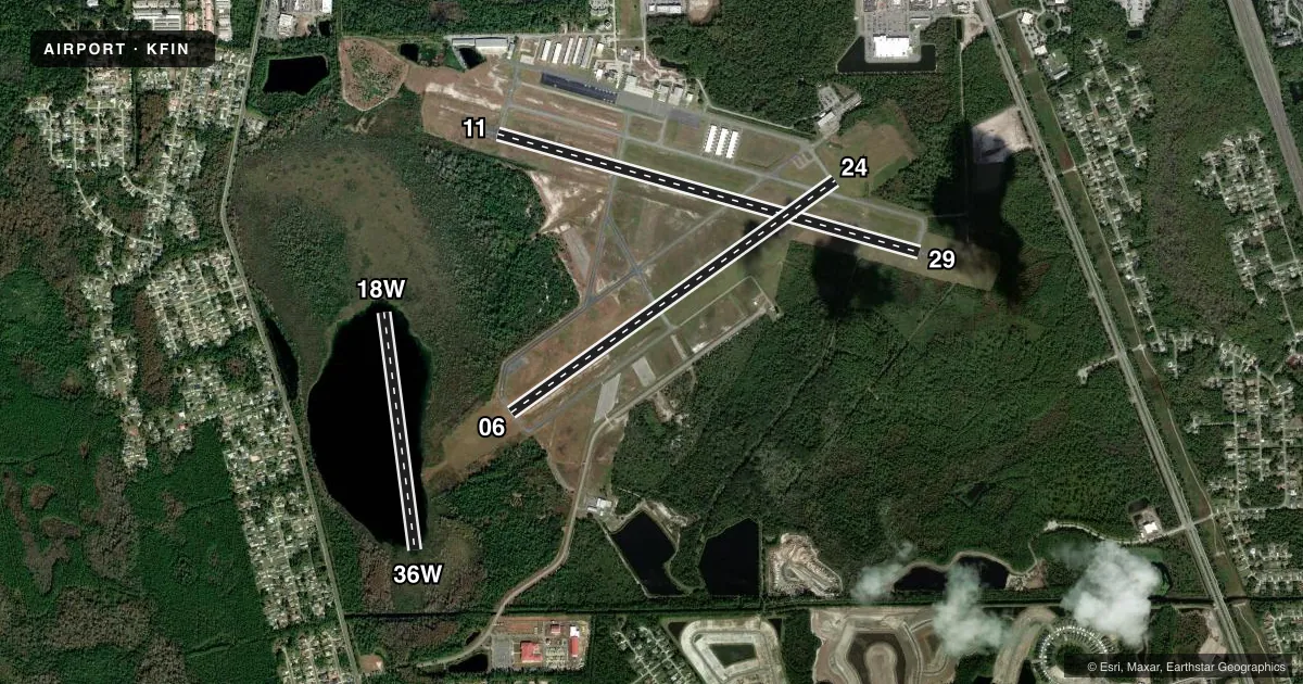
Airport sketch
Runways drawn to scale from FAA survey coordinates, rendered over satellite imagery. Not for navigation.
Approaches & charts
Services on the field
Fuel grades, oxygen, maintenance, ramp storage and lighting — as declared to the FAA by the airport operator.
Fuel & services
- Fuel
- 100LLA
- Oxygen (bottled)
- Not available
- Oxygen (bulk)
- Not available
- Airframe repair
- Major
- Power plant repair
- Major
- Other services
- CHTR,INSTR,RNTL
Ramp & ground
- Transient storage
- Tie-down
- Landing fee
- No fee published
- Customs
- Not available
- Lighting schedule
- SEE RMK
- Beacon schedule
- SS-SR
- Beacon
- White / Green (civil land)(WG)
- Wind indicator
- Lighted
- Segmented circle
- Yes
Fuel & FBOs
Cheapest 100LL and Jet A on the field and nearby. Always confirm with the FBO before taxi.
Airport notes
Surface conditions, obstructions, local procedures, lighting outages and other notes published with each FAA cycle.
General notes
- NOISE ABATEMENT PROCS IN EFCT, VOLUNTARY RESTRAINT FROM TGL OPS 0300-1200Z.
- TWY B BTN TWY A1 & D CLSD TO FIXED WING ACFT.
- FOR CD OR TO CNL IFR WHEN ATCT IS CLSD CTC DAB APCH AT 386-226-3939.
- HEL OPS CONDUCTED WI ARPT BNDRY 500 FT OR BLW UNLESS DRCTD BY ATC; HEL OPS RWY 06 & 29 LEFT TFC; HEL OPS RWY 11 & 24 RIGHT TFC.
- NOISE SENSITIVE AREA ALL QUADS OF THE ARPT.
Lighting notes
- WHEN ATCT CLSD, ACTVT REIL RWY 6, 11, 24, & 29; PAPI RWY 6, 24, 11 & 29; MIRL RWYS 6/24 & 11/29 - CTAF.
Fuel notes
- AFOR JET A FUEL AFTER HRS CALL 386-313-4220 24 HRS IN ADVANCE. FUEL NOT AVBL AT LAKE.
Runway surface & condition
- 18W/36WSEAPLANE LNDG AREA GORE LAKE 3196 FT BY 1633 FT UNMRKD; 40 FT TREES WATER EDGE ALL QUADRANTS; ALL APCHS HDG 180 DEG OR 360 DEG PAST TREES.
- H1HELIPAD NA EXC FLAGLER COUNTY EMERG SVCS.
Approach & departure obstructions
- 11RWY 11 DSGND CALM WIND RWY FOR ARRS AND DEPS 0300-1100Z.
- 24UNLGTD OBSTNS IN APCH; 1080 FT TREES BFR AER.
- 11APRCH SLP 34:1 TO AER.
Other notes
- EXISTED PRIOR TO 1959.
- MANAGER386-313-4220
VFR map & nearby airports
VFR sectional. Tap any ICAO chip to open that airport.
Key facts · KFIN
Answer card- ICAO
- KFIN
- Name
- FLAGLER EXEC
- Location
- PALM COAST, FLORIDA
- Elevation
- 33.1 ft MSL
- Traffic pattern altitude
- 1,033.1 ft MSL (1,000 AGL)
- Control tower
- Towered · 0600-2000
- Total runways
- 3
- Longest runway
- 11/29 · 5,500 ft
- Published ILS approaches
- 0
- Published frequencies
- 8
- Magnetic variation
- 6°
- Current flight rules
- VFR
- Current wind
- 000° at 0 kt
- Favored runway now
- –
Flagler Executive Airport sits in Palm Coast, Florida. Field elevation is 33.1 ft MSL. The airport has three runways. The longest is runway 11/29 at 5,500 ft. Runway 06/24 is 5,001 ft. Runway 18W/36W is a 3,001 ft water runway on Gore Lake.
The field is towered from 0600 to 2000. CTAF is 118.95 when you are outside tower coverage. No ILS approaches are published here, so plan with that in mind if the weather is marginal. The published pattern altitude is not listed. Use the standard 1,000 ft AGL pattern for light piston operations unless ATC or the current Chart Supplement says otherwise.
Flagler Executive Airport, the on-field FBO, carries 100LL and Jet A. Call the FBO directly at (386) 437-0401 for current service details. The airport remarks call out noise sensitivity in all quadrants. They also note voluntary restraint from touch-and-go operations from 0300 to 1200 Zulu. Runway 11 is the calm wind runway for arrivals and departures from 0300 to 1100 Zulu. Expect to pay close attention to the trees near the water runway and the unlighted obstructions in the approach area. If the tower is closed, use the published lighting and contact DAB Approach for IFR clearance or IFR cancellation.