METAR & TAF 28J
Current METAR
Observed 15:15Z
K28J 271515Z AUTO VRB04KT 10SM SCT029 SCT120 32/26 A2988 RMK AO2
- Wind
- VAR @ 4 kt
- Visibility
- 10 SM
- Temp / Dew
- 32°C / 26°C
- Altimeter
- 29.88 inHg
- Clouds
- SCT
- Density alt
- 2,149 ft
- Ceiling
- Unlimited
- Rules
- VFR
Airport info & contacts
Manager on record, flight service, ARTCC, attendance schedule and pattern altitude — published by the FAA and refreshed every 28 days.
Location
- From city
- 2 NM NW
- VFR sectional
- JACKSONVILLE
- ARTCC
- ZJX · JACKSONVILLE
- NOTAM facility
- GNV (NOTAM-D)
Airport manager
- Name
- YUL MCNAIR
- Phone
- 386-329-0149
- Address
- 4015 REID ST, HWY 100, PALATKA FL 32177
Flight service · Hours
- FSS GNV
- GAINESVILLE1-800-WX-BRIEF
- Attendance
- 0800-1800
Frequencies
Tap any row to copy the frequency to your clipboard.
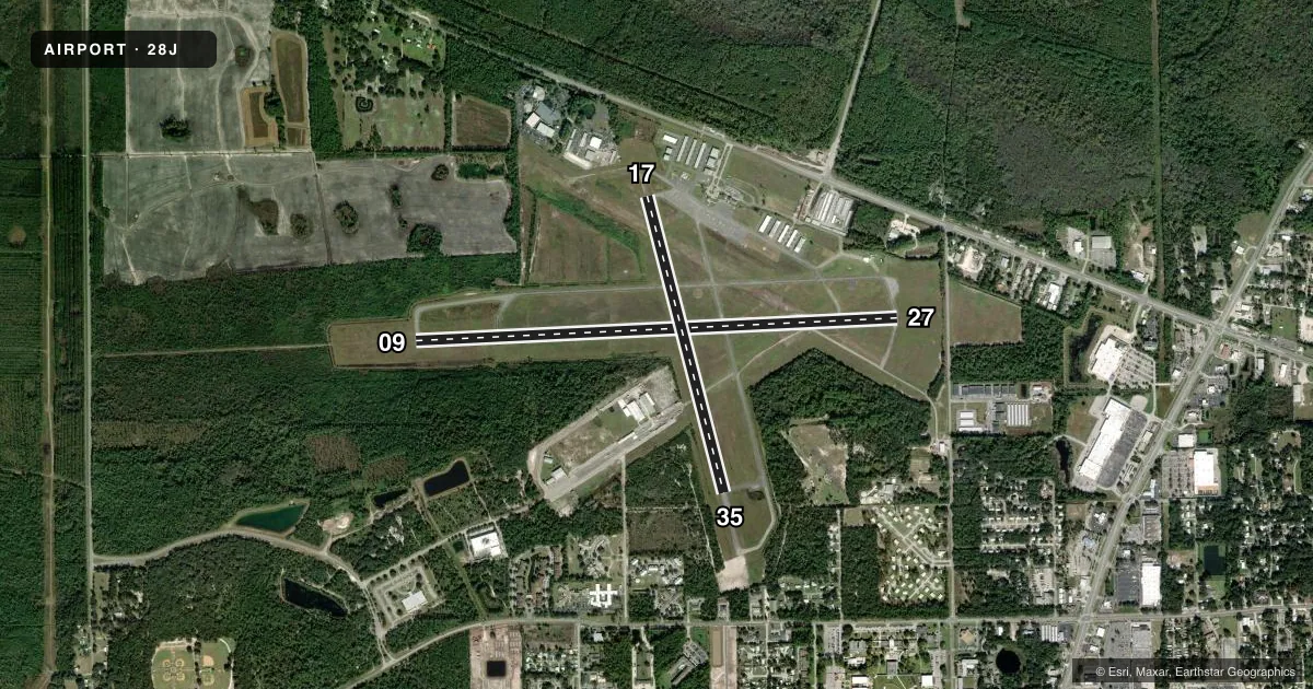
Runways & pattern
Full pagePattern entry · RWY 35
LEFT TRAFFIC| Runway | Heading (°M) | Length | Surface | Traffic |
|---|---|---|---|---|
| 09/27 | 82° / 262° | 6,000 ft | ASPH | Standard L |
| 17/35Favored | 160° / 340° | 3,804 ft | ASPH | Standard L |
Runway end performance
| End | TORA | TODA | ASDA | LDA | VGSI | Approach lights | Obstruction |
|---|---|---|---|---|---|---|---|
| 09 | 5,549' | 5,549' | 5,999' | 5,999' | PAPI 4-box left(3°) | — | 26', trees, 1140' from thr, 260' R of cntrln, slope 36 |
| 27 | 5,999' | 5,999' | 5,999' | 5,549' | PAPI 4-box left(3.5°) | — | 60', trees, 1675' from thr, 75' R of cntrln, slope 24 |
| 17 | — | — | — | — | PAPI 2-box left(3°) | — | 78', trees, 1960' from thr, 110' R of cntrln, slope 22 |
| 35 | — | — | — | — | PAPI 2-box left(3.75°) | — | 47', trees, 955' from thr, 95' R of cntrln, slope 16 |
Declared distances in feet. TORA = takeoff run available, TODA = takeoff distance, ASDA = accelerate-stop, LDA = landing distance.
Airport sketch
Runways drawn to scale from FAA survey coordinates, rendered over satellite imagery. Not for navigation.
Approaches & charts
Services on the field
Fuel grades, oxygen, maintenance, ramp storage and lighting — as declared to the FAA by the airport operator.
Fuel & services
- Fuel
- 100LLA
- Oxygen (bottled)
- Not available
- Oxygen (bulk)
- Not available
- Airframe repair
- Minor
- Power plant repair
- Major
- Other services
- INSTR,PAJA,RNTL
Ramp & ground
- Transient storage
- Tie-down
- Landing fee
- No fee published
- Customs
- Not available
- Lighting schedule
- SEE RMK
- Beacon schedule
- SS-SR
- Beacon
- White / Green (civil land)(WG)
- Wind indicator
- Lighted
Fuel & FBOs
Cheapest 100LL and Jet A on the field and nearby. Always confirm with the FBO before taxi.
Airport notes
Surface conditions, obstructions, local procedures, lighting outages and other notes published with each FAA cycle.
General notes
- WILDLIFE ON & INVOF ARPT.
Lighting notes
- ACTVT REIL RWY 09 & 27; PAPI RWY 09, 27, 17 & 35; MIRL RWY 09/27 & 17/35 - CTAF.
Fuel notes
- 100LLCREDIT CARD FUEL AVBL 24 HRS.
Runway surface & condition
- 17/35RSTRD TO ACFT 12500 LB GWT OR LESS.
Approach & departure obstructions
- 09PREFERRED RWY.
- 35PAPI UNUSBL BYD 7 DEG LEFT OF CNTRLN.
- 27APCH SLP 37:1 TO DTHR.
Other notes
- VFR OPS ONLY.
- WND CONE CIRCLED CONCRETE.
- OWNERARPT PHYS ADS: 4015 REID STREET; 386-329-0148.
VFR map & nearby airports
VFR sectional. Tap any ICAO chip to open that airport.
Key facts · 28J
Answer card- ICAO
- 28J
- Name
- PALATKA MUNI/LT KAY LARKIN FLD
- Location
- PALATKA, FLORIDA
- Elevation
- 47.8 ft MSL
- Traffic pattern altitude
- 1,047.8 ft MSL (1,000 AGL)
- Control tower
- Non-towered (use CTAF)
- Total runways
- 2
- Longest runway
- 09/27 · 6,000 ft
- Published ILS approaches
- 0
- Published frequencies
- 4
- Magnetic variation
- 5°
- Current flight rules
- VFR
- Current wind
- 000° at 4 kt
- Favored runway now
- RWY 35
Palatka Muni/Lt Kay Larkin Fld is in Palatka, Florida. Field elevation is 47.8 ft MSL. The airport has two asphalt runways. The longest is 6,000 ft on runway 09/27. There is no control tower, so expect non-towered traffic flow on CTAF 122.8. No ILS approaches are published here, so plan with that in mind if the weather is marginal.
Pattern altitude is not published. Use the standard 1,000 ft AGL pattern for light piston traffic unless the current FAA Chart Supplement or local procedures say otherwise. The field is VFR only per the published remarks. Runway 09 is the preferred runway. Runway 17/35 is limited to aircraft at 12,500 lb gross weight or less. Wildlife is present on and near the airport, so keep a sharp scan on taxi, takeoff and landing.
Palatka Municipal Airport is on the field and carries 100LL and Jet A Prist. Credit card fuel is available 24 hours. Runway 09 and 27 have REILs. All four runways have PAPI. Medium intensity runway lights are on 09/27 and 17/35. For the runway 35 approach, the PAPI is unusable beyond 7 degrees left of centerline. The runway 27 approach slope to the displaced threshold is 37 to 1. If you need current operational detail, verify with the airport operator or the FBO directly by phone before arrival.