METAR & TAF KGNV
Current METAR
Observed 15:53Z
KGNV 271553Z 34004KT 10SM CLR 30/24 A2994 RMK AO2 SLP133 T03000239
- Wind
- 340° @ 4 kt
- Visibility
- 10 SM
- Temp / Dew
- 30°C / 24°C
- Altimeter
- 29.94 inHg
- Clouds
- CLR
- Density alt
- 1,963 ft
- Ceiling
- Unlimited
- Rules
- VFR
Airport info & contacts
Manager on record, flight service, ARTCC, attendance schedule and pattern altitude — published by the FAA and refreshed every 28 days.
Location
- From city
- 3 NM NE
- VFR sectional
- JACKSONVILLE
- ARTCC
- ZJX · JACKSONVILLE
- NOTAM facility
- GNV (NOTAM-D)
Airport manager
- Name
- ALLAN PENKSA
- Phone
- 352-373-0249
- Address
- 3880 NE 39 AVE STE A, GAINESVILLE FL 32609
Flight service · Hours
- FSS GNV
- GAINESVILLE1-800-WX-BRIEF
- Attendance
- ALL
Frequencies
Tap any row to copy the frequency to your clipboard.
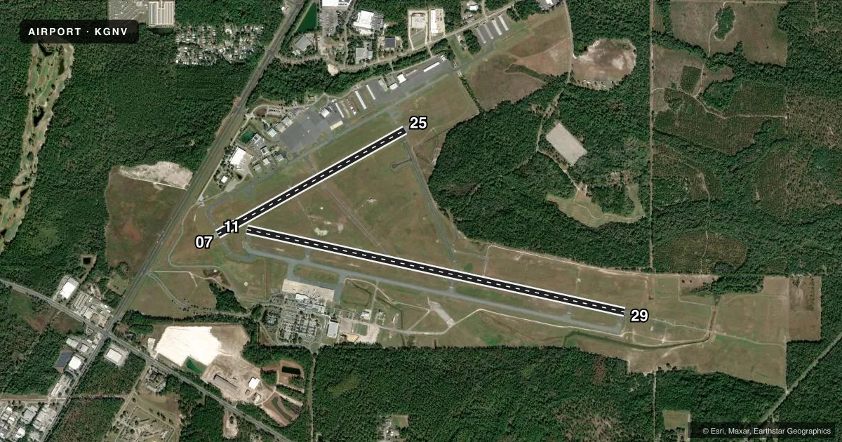
Runways & pattern
Full pagePattern entry · RWY 29
LEFT TRAFFIC| Runway | Heading (°M) | Length | Surface | Traffic |
|---|---|---|---|---|
| 11/29Favored | 98° / 278° | 7,504 ft | ASPH | Standard L |
| 07/25 | 57° / 237° | 4,158 ft | ASPH | Standard L |
Runway end performance
| End | TORA | TODA | ASDA | LDA | VGSI | Approach lights | Obstruction |
|---|---|---|---|---|---|---|---|
| 11 | — | — | — | — | PAPI 4-box left(3°) | — | 81', trees, 2783' from thr, 626' R of cntrln, slope 31 |
| 29 | — | — | — | — | PAPI 4-box right(3°) | MALSR | 68', trees, 3535' from thr, 458' R of cntrln, slope 49 |
| 07 | — | — | — | — | PAPI 4-box left(3°) | — | 70', trees, 2006' from thr, 432' R of cntrln, slope 25 |
| 25 | — | — | — | — | PAPI 4-box left(3°) | — | 34', trees, 1389' from thr, 423' R of cntrln, slope 34 |
Declared distances in feet. TORA = takeoff run available, TODA = takeoff distance, ASDA = accelerate-stop, LDA = landing distance.
Airport sketch
Runways drawn to scale from FAA survey coordinates, rendered over satellite imagery. Not for navigation.
Approaches & charts
ILS · 1
Services on the field
Fuel grades, oxygen, maintenance, ramp storage and lighting — as declared to the FAA by the airport operator.
Fuel & services
- Fuel
- 100A
- Oxygen (bottled)
- High pressure
- Oxygen (bulk)
- High pressure
- Airframe repair
- Major
- Power plant repair
- Major
- Other services
- CARGO,INSTR,RNTL,SALES
Ramp & ground
- Transient storage
- Tie-down
- Hangar
- Landing fee
- No fee published
- Customs
- Not available
- Lighting schedule
- SEE RMK
- Beacon schedule
- SS-SR
- Beacon
- White / Green (civil land)(WG)
- Wind indicator
- Lighted
- Segmented circle
- Yes
Fuel & FBOs
Cheapest 100LL and Jet A on the field and nearby. Always confirm with the FBO before taxi.
Airport notes
Surface conditions, obstructions, local procedures, lighting outages and other notes published with each FAA cycle.
General notes
- WHEN ATCT CLSD ACFT MORE THAN 12500 LBS CTC FBO FOR PRKG INSTR PRIOR TO EXITING TWY A DUE TO IREG PAVEMENT STRENGTHS - 352-335-4681.
- PORTIONS OF RWY 07/25 & NE 1000 FT OF TWY A NOT VSB FM ATCT; BLOCKED BY VORTAC BLDG.
- WILDLIFE ON & INVOF ARPT.
- GA RAMP LMTD TO ACFT 110,000 LB OR BLW; OTHERS PPR.
- BANNER TOWING NA EXC 72 HR PPR - AMGR.
- ARPT SFC COND NOT MNTD BTW 2330 - 0400 DLY.
- FOR CD IF UNA TO CTC ON FSS FREQ, CTC JACKSONVILLE APCH AT 904-741-0284.
- RWY 11-29 MRKGS ON W END ARE NOT STD DUE TO MRKGS NOT FULLY REMOVED/GHOSTING.
- TWY B LMTD TO 75,000 LB OR BLW; OTHERS PPR
- TWY C LMTD TO 120,000 LB OR BLW; OTHERS PPR
- TWY D LMTD TO 120,000 LB OR BLW; OTHERS PPR
- 24 HR PPR FOR ACFT EQUIPPED WITH WEATHER MODIFICATION OR GEOENGINEERING EQPT 352-262-6691.
Lighting notes
- WHEN ATCT CLSD ACTVT MALSR RWY 29; MIRL RWY 07/25; HIRL RWY 11/29 - CTAF.
Runway surface & condition
- 07/25PCR VALUE: 320/F/B/X/T
- 11/29PCR VALUE: 480/F/B/X/T
- 07/25RWY 07/25 NOT AVBL FOR PART 121/PART 380 OPS WITH SKED PAX CARRYING OPS MORE THAN 9 PAX SEATS AND NON-SKED PAX CARRYING OPS MORE THAN 30 PAX SEATS.
Other notes
- THIS AIRPORT HAS BEEN SURVEYED BY THE NATIONAL GEODETIC SURVEY.
- RWY 7/25 NOT AVBL FOR SKED ACR OPS WITH MORE THAN 9 PAX SEATS OR UNSKED ACR AT LEAST 31 PAX SEATS.
- OWNERGAINESVILLE-ALACHUA CO REGIONAL ARPT AUTHORITY
- 11/29STD GROOVING FULL LENGTH AND 130 FT WIDE CENTER PORTION.
VFR map & nearby airports
VFR sectional. Tap any ICAO chip to open that airport.
Key facts · KGNV
Answer card- ICAO
- KGNV
- Name
- GAINESVILLE RGNL
- Location
- GAINESVILLE, FLORIDA
- Elevation
- 151.4 ft MSL
- Traffic pattern altitude
- 1,151.4 ft MSL (1,000 AGL)
- Control tower
- Towered · 0645-2230
- Total runways
- 2
- Longest runway
- 11/29 · 7,504 ft
- Published ILS approaches
- 1
- Published frequencies
- 8
- Magnetic variation
- 4°
- Current flight rules
- VFR
- Current wind
- 340° at 4 kt
- Favored runway now
- RWY 29
Gainesville Regional Airport sits in Gainesville, Florida. The field elevation is 151.4 ft MSL. It has two asphalt runways. The longest is runway 11/29 at 7,504 ft. Tower service is published from 0645 to 2230. One ILS is available to runway 29.
Pattern altitude is not published. Use 1,000 ft AGL for light piston traffic unless ATC or the current Chart Supplement says otherwise. University Air Center is on the field. It carries AVGAS 100LL, JET A and JET A Prist. The airport is in a busy controlled environment. Expect normal tower sequencing and Jacksonville approach control on the published frequencies.
A few operational notes matter here. When the tower is closed, runway 29 uses MALSR lighting. Runway 07/25 and runway 11/29 also have published lighting activation procedures. Parts of runway 07/25 and the northeast 1,000 ft of taxiway A are not visible from the tower because of the VORTAC building. Taxiway C and taxiway D are limited to 120,000 lb or below unless prior permission is obtained. Surface condition is not maintained between 2330 and 0400 daily. If you are planning a heavier aircraft or a night arrival, verify the latest airport notes with the current Chart Supplement or the airport operator before departure.