METAR & TAF KLCQ
Current METAR
Observed 13:15Z
KLCQ 271315Z AUTO 31004KT 10SM OVC110 26/22 A2991 RMK AO2
- Wind
- 310° @ 4 kt
- Visibility
- 10 SM
- Temp / Dew
- 26°C / 22°C
- Altimeter
- 29.91 inHg
- Clouds
- OVC
- Density alt
- 1,581 ft
- Ceiling
- 11,000 ft AGL
- Rules
- VFR
Airport info & contacts
Manager on record, flight service, ARTCC, attendance schedule and pattern altitude — published by the FAA and refreshed every 28 days.
Location
- From city
- 3 NM E
- VFR sectional
- JACKSONVILLE
- ARTCC
- ZJX · JACKSONVILLE
- NOTAM facility
- GNV (NOTAM-D)
Airport manager
- Name
- ED BUNNELL
- Phone
- 386-752-1066
- Address
- 3524 E US HWY 90, LAKE CITY FL 32055
Flight service · Hours
- FSS GNV
- GAINESVILLE1-800-WX-BRIEF
- Attendance
- 0800-1800
Frequencies
Tap any row to copy the frequency to your clipboard.
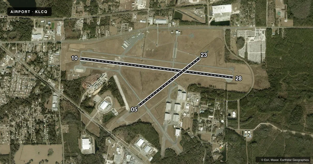
Runways & pattern
Full pagePattern entry · RWY 28
RIGHT TRAFFIC| Runway | Heading (°M) | Length | Surface | Traffic |
|---|---|---|---|---|
| 10/28Favored | 94° / 274° | 8,003 ft | ASPH | 28 R |
| 05/23 | 49° / 229° | 4,000 ft | ASPH | Standard L |
Runway end performance
| End | TORA | TODA | ASDA | LDA | VGSI | Approach lights | Obstruction |
|---|---|---|---|---|---|---|---|
| 10 | — | — | — | — | PAPI 2-box left(3°) | — | 42', trees, 1425' from thr, 185' R of cntrln, slope 29 |
| 28 | — | — | — | — | PAPI 2-box left(3°) | — | 48', trees, 1885' from thr, 250' R of cntrln, slope 35 |
| 05 | — | — | — | — | — | — | 64', trees, 1690' from thr, 250' R of cntrln, slope 23 |
| 23 | — | — | — | — | — | — | 50', trees, 1625' from thr, 265' R of cntrln, slope 28 |
Declared distances in feet. TORA = takeoff run available, TODA = takeoff distance, ASDA = accelerate-stop, LDA = landing distance.
Airport sketch
Runways drawn to scale from FAA survey coordinates, rendered over satellite imagery. Not for navigation.
Approaches & charts
Services on the field
Fuel grades, oxygen, maintenance, ramp storage and lighting — as declared to the FAA by the airport operator.
Fuel & services
- Fuel
- 100LLA
- Oxygen (bottled)
- Not available
- Oxygen (bulk)
- Not available
- Airframe repair
- Minor
- Power plant repair
- Minor
- Other services
- AMB,INSTR
Ramp & ground
- Transient storage
- Tie-down
- Landing fee
- No fee published
- Customs
- Not available
- Lighting schedule
- SEE RMK
- Beacon schedule
- SS-SR
- Beacon
- White / Green (civil land)(WG)
- Wind indicator
- Lighted
- Segmented circle
- Yes
Fuel & FBOs
Cheapest 100LL and Jet A on the field and nearby. Always confirm with the FBO before taxi.
Airport notes
Surface conditions, obstructions, local procedures, lighting outages and other notes published with each FAA cycle.
General notes
- UNLIT 60 FT POLES ON MOVEMENT AREA. HELICOPTERS ADVISED TO TAXI ON PAVED AREAS ONLY.
- WHEN ATCT CLSD, FOR CD CTC JACKSONVILLE ARTCC AT 904-845-1592.
Lighting notes
- ACTVT REIL RWY 10 & 28; MIRL RWY 5/23 & 10/28 - CTAF.
Runway surface & condition
- 05/23PCR VALUE: 11/F/A/Y/T
Other notes
- 1TWR ATNDD OTR TIMES BY NOTAM.
- OWNERCTC PERSON: DEMETRIUS JOHNSON
VFR map & nearby airports
VFR sectional. Tap any ICAO chip to open that airport.
Key facts · KLCQ
Answer card- ICAO
- KLCQ
- Name
- LAKE CITY GATEWAY
- Location
- LAKE CITY, FLORIDA
- Elevation
- 200.7 ft MSL
- Traffic pattern altitude
- 1,200.7 ft MSL (1,000 AGL)
- Control tower
- Towered · 0800-1630 MON-FRI
- Total runways
- 2
- Longest runway
- 10/28 · 8,003 ft
- Published ILS approaches
- 0
- Published frequencies
- 6
- Magnetic variation
- 3°
- Current flight rules
- VFR
- Current wind
- 310° at 4 kt
- Favored runway now
- RWY 28
Lake City Gateway is in Lake City, Florida. The field elevation is 200.7 ft MSL. It has two asphalt runways. The longest is runway 10/28 at 8,003 ft. Runway 05/23 is 4,000 ft. The tower is open 0800-1630 Monday through Friday. The tower is also attended at other times by NOTAM. No ILS approaches are published here.
Pattern altitude is not published. Use 1,000 ft AGL for light piston traffic unless the current Chart Supplement says otherwise. Lake City Gateway FBO is on the field. It carries 100LL and Jet A. Contact the FBO directly for current ramp and fuel details. Published remarks also note runway end identifier lights on 10 and 28. Medium intensity runway lights are on 05/23 and 10/28. They are controlled by CTAF. There are unlit 60-foot poles on the movement area. Helicopters should taxi on paved areas only.
This is a towered field with weekday published hours. When the tower is closed, clearance delivery goes through Jacksonville ARTCC. Check the current Chart Supplement before you go. That is the place to confirm any current procedures, lighting notes, or other operational changes.