METAR & TAF 24J
Current METAR
Observed 16:35Z
K24J 271635Z AUTO 00000KT 10SM FEW040 FEW048 34/24 A2990 RMK A01
- Wind
- 000° @ 0 kt
- Visibility
- 10 SM
- Temp / Dew
- 34°C / 24°C
- Altimeter
- 29.90 inHg
- Clouds
- FEW
- Density alt
- 2,433 ft
- Ceiling
- Unlimited
- Rules
- VFR
Airport info & contacts
Manager on record, flight service, ARTCC, attendance schedule and pattern altitude — published by the FAA and refreshed every 28 days.
Location
- From city
- 2 NM W
- VFR sectional
- JACKSONVILLE
- Pattern altitude
- 1,197 ft AGL · 1,300 ft MSL
- ARTCC
- ZJX · JACKSONVILLE
- NOTAM facility
- GNV (NOTAM-D)
Airport manager
- Name
- JOHN DUHAIME
- Phone
- 386-362-4200
- Address
- 13302 80TH TER, LIVE OAK FL 32060
Flight service · Hours
- FSS GNV
- GAINESVILLE1-800-WX-BRIEF
- Attendance
- MON-FRI · 0800-1700
Frequencies
Tap any row to copy the frequency to your clipboard.
Runways & pattern
Full pagePattern entry · RWY 07
LEFT TRAFFICRunway end performance
| End | TORA | TODA | ASDA | LDA | VGSI | Approach lights | Obstruction |
|---|---|---|---|---|---|---|---|
| 07 | — | — | — | — | PAPI 2-box left(3°) | — | 66', trees, 1735' from thr, 140' R of cntrln, slope 23 |
| 25 | — | — | — | — | PAPI 2-box left(3°) | — | 47', trees, 1800' from thr, 260' R of cntrln, slope 34 |
Declared distances in feet. TORA = takeoff run available, TODA = takeoff distance, ASDA = accelerate-stop, LDA = landing distance.
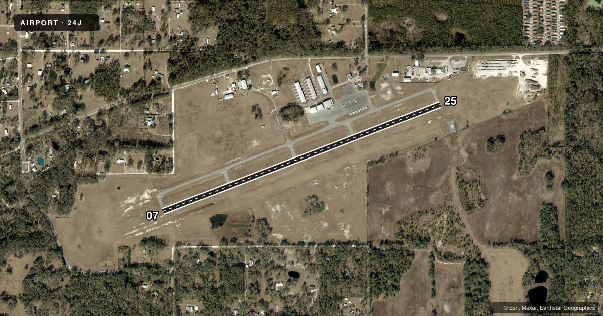
Airport sketch
Runways drawn to scale from FAA survey coordinates, rendered over satellite imagery. Not for navigation.
Approaches & charts
Services on the field
Fuel grades, oxygen, maintenance, ramp storage and lighting — as declared to the FAA by the airport operator.
Fuel & services
- Fuel
- 100LLAA+
- Oxygen (bottled)
- Not available
- Oxygen (bulk)
- Not available
- Airframe repair
- Minor
- Power plant repair
- Minor
- Other services
- AGRI,AMB,INSTR
Ramp & ground
- Transient storage
- Tie-down
- Landing fee
- No fee published
- Customs
- Not available
- Lighting schedule
- SEE RMK
- Beacon schedule
- SS-SR
- Beacon
- White / Green (civil land)(WG)
- Wind indicator
- Lighted
Fuel & FBOs
Cheapest 100LL and Jet A on the field and nearby. Always confirm with the FBO before taxi.
Airport notes
Surface conditions, obstructions, local procedures, lighting outages and other notes published with each FAA cycle.
General notes
- FOR CD CTC JACKSONVILLE ARTCC AT 904-845-1592.
- 24 HR PPR FOR ACFT EQUIPPED WITH WEATHER MODIFICATION OR GEOENGINEERING EQPT 386-368-4200.
Lighting notes
- ACTVT REIL RWY 07 & 25; PAPI RWY 07 & 25; MIRL RWY 07/25 - CTAF.
Other notes
- VFR OPS ONLY.
- TPA: 1197 FT AGL PROP, 1697 FT AGL TBJT.
- OWNERCTC: JASON FURRY
VFR map & nearby airports
VFR sectional. Tap any ICAO chip to open that airport.
Key facts · 24J
Answer card- ICAO
- 24J
- Name
- SUWANNEE COUNTY
- Location
- LIVE OAK, FLORIDA
- Elevation
- 103.3 ft MSL
- Traffic pattern altitude
- 1,300.3 ft MSL (1,197 AGL)
- Control tower
- Non-towered (use CTAF)
- Total runways
- 1
- Longest runway
- 07/25 · 4,005 ft
- Published ILS approaches
- 0
- Published frequencies
- 2
- Magnetic variation
- 5°
- Current flight rules
- VFR
- Current wind
- 000° at 0 kt
- Favored runway now
- –
Suwannee County Airport (24J) sits in Live Oak, Florida. Field elevation is 103.3 ft MSL. The airport has one runway. Runway 07/25 is 4,005 ft of asphalt. There is no control tower. Use CTAF 122.8 for local traffic. UNICOM is also 122.8.
No ILS approaches are published here. This is a VFR-only field per the published remarks. Pattern altitude is 1,300.3 ft MSL. That is 1,197 ft AGL over the property. The runway has REILs, PAPI and medium intensity runway lights on 07/25. That helps for night work. You still need to stay within the published VFR setup.
The on-field FBO is Suwannee County. It carries 100LL and Jet A. Call (386) 362-4200 for current services before you go. For clearance delivery, the Chart Supplement says to contact Jacksonville ARTCC at 904-845-1592. If you are planning an IFR departure or arrival, verify the current procedure details with the FAA Chart Supplement before the flight. The airport sits in north Florida. Expect a straightforward low-elevation environment with no towered sequencing. Use the common traffic advisory frequency. Keep a close ear on pattern traffic.