METAR & TAF 4J5
4J5 does not publish a METAR.
Showing the nearest reporting station: KTVI (THOMASVILLE RGNL) · 16.1 NM away. Conditions at 4J5 may differ.
METAR · KTVI
Observed 21:35Z
KTVI 262135Z AUTO 29006KT 10SM CLR 31/23 A2994 RMK AO2
- Wind
- 290° @ 6 kt
- Visibility
- 10 SM
- Temp / Dew
- 31°C / 23°C
- Altimeter
- 29.94 inHg
- Clouds
- CLR
- Density alt
- 2,124 ft
- Ceiling
- Unlimited
- Rules
- VFR
Airport info & contacts
Manager on record, flight service, ARTCC, attendance schedule and pattern altitude — published by the FAA and refreshed every 28 days.
Location
- From city
- 2 NM NW
- VFR sectional
- JACKSONVILLE
- ARTCC
- ZJX · JACKSONVILLE
- NOTAM facility
- MCN (NOTAM-D)
Airport manager
- Name
- ROBIN MCDANIEL
- Phone
- 229-263-1418
- Address
- 810 OLD MADISON ROAD, QUITMAN GA 31643
Flight service · Hours
- FSS MCN
- MACON1-800-WX-BRIEF
- Attendance
- UNATTENDED
Frequencies
Tap any row to copy the frequency to your clipboard.
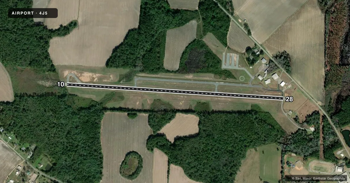
Runways & pattern
Full pagePattern entry · RWY 28
LEFT TRAFFICRunway end performance
| End | TORA | TODA | ASDA | LDA | VGSI | Approach lights | Obstruction |
|---|---|---|---|---|---|---|---|
| 10 | — | — | — | — | PAPI 2-box left(3°) | — | 86', trees, 286' from thr, 268' R of cntrln, slope 1 |
| 28 | — | — | — | — | PAPI 2-box right(4°) | — | 35', pline, 895' from thr, 0' R of cntrln, slope 19 |
Declared distances in feet. TORA = takeoff run available, TODA = takeoff distance, ASDA = accelerate-stop, LDA = landing distance.
Airport sketch
Runways drawn to scale from FAA survey coordinates, rendered over satellite imagery. Not for navigation.
Approaches & charts
Services on the field
Fuel grades, oxygen, maintenance, ramp storage and lighting — as declared to the FAA by the airport operator.
Fuel & services
- Fuel
- Not available
- Oxygen (bottled)
- Not available
- Oxygen (bulk)
- Not available
- Airframe repair
- Not available
- Power plant repair
- Not available
- Other services
- AGRI,GLD
Ramp & ground
- Transient storage
- Tie-down
- Landing fee
- No fee published
- Customs
- Not available
- Lighting schedule
- SEE RMK
- Beacon schedule
- SS-SR
- Beacon
- White / Green (civil land)(WG)
- Wind indicator
- Yes
- Segmented circle
- Yes
Fuel & FBOs
Cheapest 100LL and Jet A on the field and nearby. Always confirm with the FBO before taxi.
Airport notes
Surface conditions, obstructions, local procedures, lighting outages and other notes published with each FAA cycle.
General notes
- WILDLIFE ON & INVOF ARPT.
- GLIDER OPNS ON WKEND.
- FOR CD CTC VALDOSTA APCH AT 229-257-2207, WHEN APCH CLSD CTC JACKSONVILLE ARTCC AT 904-845-1592.
Lighting notes
- ACTVT PAPI RWY 10 & 28; MIRL RWY 10/28 - CTAF.
Approach & departure obstructions
- 283 FT HI GND 100 FT RIGHT 0 FT-200 FT FM END OF RWY.
Other notes
- EXISTED PRIOR TO 1959.
VFR map & nearby airports
VFR sectional. Tap any ICAO chip to open that airport.
Key facts · 4J5
Answer card- ICAO
- 4J5
- Name
- QUITMAN BROOKS COUNTY
- Location
- QUITMAN, GEORGIA
- Elevation
- 184.9 ft MSL
- Traffic pattern altitude
- 1,184.9 ft MSL (1,000 AGL)
- Control tower
- Non-towered (use CTAF)
- Total runways
- 1
- Longest runway
- 10/28 · 5,000 ft
- Published ILS approaches
- 0
- Published frequencies
- 3
- Magnetic variation
- 5°
- Current flight rules
- VFR
- Current wind
- 290° at 6 kt
- Favored runway now
- RWY 28
Quitman Brooks County Airport is in Quitman, Georgia. Field elevation is 184.9 ft MSL. The airport has one runway. Runway 10/28 is 5,000 ft long with asphalt pavement. The runway headings are 94° and 274° magnetic.
There is no control tower. Use CTAF 122.9 for local traffic. Valdosta Approach handles approach and departure work on 126.6 and 132.375. No ILS approaches are published here, so plan with the current charted procedures before you go. Pattern altitude is not published. Use the standard 1,000 ft AGL pattern unless current published guidance says otherwise.
The field has medium intensity runway lights on 10 and 28. The precision approach path indicators are active on both ends. Glider operations occur on weekends. Wildlife is present on and near the airport, so keep your scan tight on arrival and departure. There is also a small ground obstruction near the departure end of runway 28, 100 ft right of centerline. No on-field FBOs are listed, so call the airport operator or the field directly before arrival if you need fuel or ramp details.