METAR & TAF 15J
15J does not publish a METAR.
Showing the nearest reporting station: KTMA (HENRY TIFT MYERS) · 17.7 NM away. Conditions at 15J may differ.
METAR · KTMA
Observed 15:15Z
KTMA 271515Z AUTO 33006KT 10SM CLR 32/27 A2993 RMK AO2 T03230273 $
- Wind
- 330° @ 6 kt
- Visibility
- 10 SM
- Temp / Dew
- 32°C / 27°C
- Altimeter
- 29.93 inHg
- Clouds
- CLR
- Density alt
- 2,319 ft
- Ceiling
- Unlimited
- Rules
- VFR
Airport info & contacts
Manager on record, flight service, ARTCC, attendance schedule and pattern altitude — published by the FAA and refreshed every 28 days.
Location
- From city
- 1 NM W
- VFR sectional
- JACKSONVILLE
- ARTCC
- ZJX · JACKSONVILLE
- NOTAM facility
- MCN (NOTAM-D)
Airport manager
- Name
- JERRY CONNELL
- Phone
- (229) 507-1340
- Address
- 160 AIRPORT RD., ADEL GA 31620
Flight service · Hours
- FSS MCN
- MACON1-800-WX-BRIEF
- Attendance
- MON - SAT · 0800-1700
Frequencies
Tap any row to copy the frequency to your clipboard.
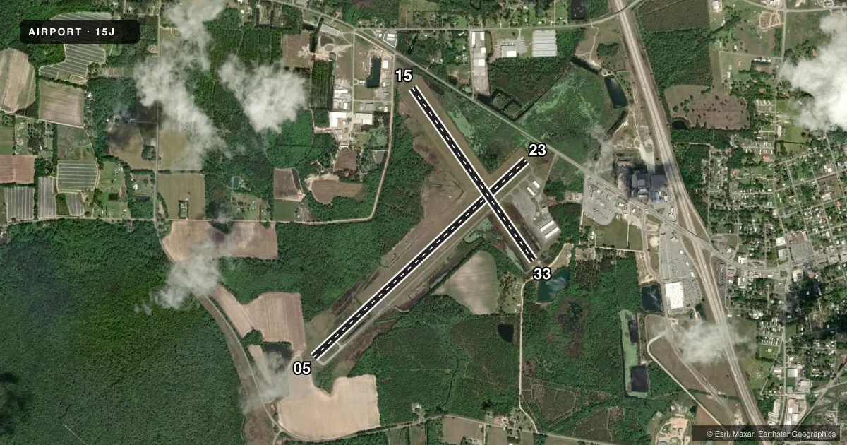
Runways & pattern
Full pagePattern entry · RWY 33
LEFT TRAFFIC| Runway | Heading (°M) | Length | Surface | Traffic |
|---|---|---|---|---|
| 05/23 | 43° / 223° | 5,502 ft | ASPH | Standard L |
| 15/33Favored | 141° / 321° | 3,999 ft | ASPH | Standard L |
Runway end performance
| End | TORA | TODA | ASDA | LDA | VGSI | Approach lights | Obstruction |
|---|---|---|---|---|---|---|---|
| 05 | — | — | — | — | PAPI 2-box left(3°) | — | 12', other, 224' from thr, 0' R of cntrln, slope 2 |
| 23 | — | — | — | — | PAPI 2-box left(3°) | — | 15', road, 350' from thr, 262' R of cntrln, slope 10 |
| 15 | 3,999' | 3,999' | 3,859' | 3,259' | — | — | 15', road, 400' from thr, 140' R of cntrln, slope 13 |
| 33 | 3,999' | 3,999' | 3,999' | 3,650' | — | — | 15', road, 260' from thr, 0' R of cntrln, slope 4 |
Declared distances in feet. TORA = takeoff run available, TODA = takeoff distance, ASDA = accelerate-stop, LDA = landing distance.
Airport sketch
Runways drawn to scale from FAA survey coordinates, rendered over satellite imagery. Not for navigation.
Approaches & charts
Services on the field
Fuel grades, oxygen, maintenance, ramp storage and lighting — as declared to the FAA by the airport operator.
Fuel & services
- Fuel
- 100LLA+
- Oxygen (bottled)
- Not available
- Oxygen (bulk)
- Not available
- Airframe repair
- Major
- Power plant repair
- Major
- Other services
- INSTR
Ramp & ground
- Transient storage
- Tie-down
- Landing fee
- No fee published
- Customs
- Not available
- Lighting schedule
- SEE RMK
- Beacon schedule
- SS-SR
- Beacon
- White / Green (civil land)(WG)
- Wind indicator
- Lighted
- Segmented circle
- Yes
Fuel & FBOs
Cheapest 100LL and Jet A on the field and nearby. Always confirm with the FBO before taxi.
Airport notes
Surface conditions, obstructions, local procedures, lighting outages and other notes published with each FAA cycle.
General notes
- FOR CD CTC VALDOSTA APCH AT 229-257-2207, WHEN APCH CLSD CTC JACKSONVILLE ARTCC AT 904-845-1592.
- UNICOM IS UNMON.
Lighting notes
- ACTVT PAPI RWY 05 & 23; MIRL RWY 05/23 - CTAF.
Approach & departure obstructions
- 15RWY 15 APCH RATIO 20:1 TO DSPLCD THR.
- 33RWY 33 APCH RATIO 12:1 TO DSPLCD THR.
- 05PLOWED FLD 224 FT FROM EOR. 12 FT FARM EQPT POSS.
Other notes
- EXISTED PRIOR TO 1959.
VFR map & nearby airports
VFR sectional. Tap any ICAO chip to open that airport.
Key facts · 15J
Answer card- ICAO
- 15J
- Name
- COOK COUNTY
- Location
- ADEL, GEORGIA
- Elevation
- 235.2 ft MSL
- Traffic pattern altitude
- 1,235.2 ft MSL (1,000 AGL)
- Control tower
- Non-towered (use CTAF)
- Total runways
- 2
- Longest runway
- 05/23 · 5,502 ft
- Published ILS approaches
- 0
- Published frequencies
- 5
- Magnetic variation
- 4°
- Current flight rules
- VFR
- Current wind
- 330° at 6 kt
- Favored runway now
- RWY 33
Cook County Airport sits in Adel, Georgia. The field elevation is 235.2 ft MSL. It has two asphalt runways. The longest is runway 05/23 at 5,502 ft. There is no control tower. Pattern altitude is not published, so use the standard 1,000 ft AGL for light piston operations unless the current Chart Supplement says otherwise.
No ILS approaches are published here. For IFR work, clearance delivery goes through Valdosta Approach. When Approach is closed, contact Jacksonville ARTCC. UNICOM is unmonitored, so do not expect a staffed advisory frequency on the field. CTAF and UNICOM are both 122.8.
Cook County Airport is home to Cook County Airport FBO. It carries 100LL and Jet A. Call ahead at (229) 896-3858 before arrival. Published remarks also note PAPI and medium intensity runway lights on runways 05 and 23. Those lights are controlled by CTAF. There are also published obstruction notes near the runway ends. Runway 05 has a plowed field close off the departure end with possible farm equipment. Runways 15 and 33 have displaced threshold approach ratios published, so review the current Chart Supplement before you plan a short-field arrival or departure.
For a first-time pilot, the main things to watch are the non-towered pattern, the published obstructions and the lack of ILS. Check the current Chart Supplement for any noise or curfew restrictions before flying into the field.