METAR & TAF KSYV
KSYV does not publish a METAR.
Showing the nearest reporting station: KABY (SOUTHWEST GEORGIA RGNL) · 15.4 NM away. Conditions at KSYV may differ.
METAR · KABY
Observed 12:53Z
KABY 271253Z 27004KT 8SM CLR 27/25 A2993 RMK AO2 SLP131 T02720250
- Wind
- 270° @ 4 kt
- Visibility
- 8 SM
- Temp / Dew
- 27°C / 25°C
- Altimeter
- 29.93 inHg
- Clouds
- CLR
- Density alt
- 1,927 ft
- Ceiling
- Unlimited
- Rules
- VFR
Airport info & contacts
Manager on record, flight service, ARTCC, attendance schedule and pattern altitude — published by the FAA and refreshed every 28 days.
Location
- From city
- 3 NM NW
- VFR sectional
- JACKSONVILLE
- ARTCC
- ZJX · JACKSONVILLE
- NOTAM facility
- MCN (NOTAM-D)
Airport manager
- Name
- CHRIS DAVIS
- Phone
- 229-776-8505
- Address
- 101 NORTH MAIN STREET, SYLVESTER GA 31791
Flight service · Hours
- FSS MCN
- MACON1-800-WX-BRIEF
- Attendance
- M-F · 0800-1700
Frequencies
Tap any row to copy the frequency to your clipboard.
Runways & pattern
Full pagePattern entry · RWY 19
LEFT TRAFFICRunway end performance
| End | TORA | TODA | ASDA | LDA | VGSI | Approach lights | Obstruction |
|---|---|---|---|---|---|---|---|
| 01 | — | — | — | — | PAPI 2-box left(3°) | — | — |
| 19 | — | — | — | — | PAPI 2-box left(3°) | — | — |
Declared distances in feet. TORA = takeoff run available, TODA = takeoff distance, ASDA = accelerate-stop, LDA = landing distance.
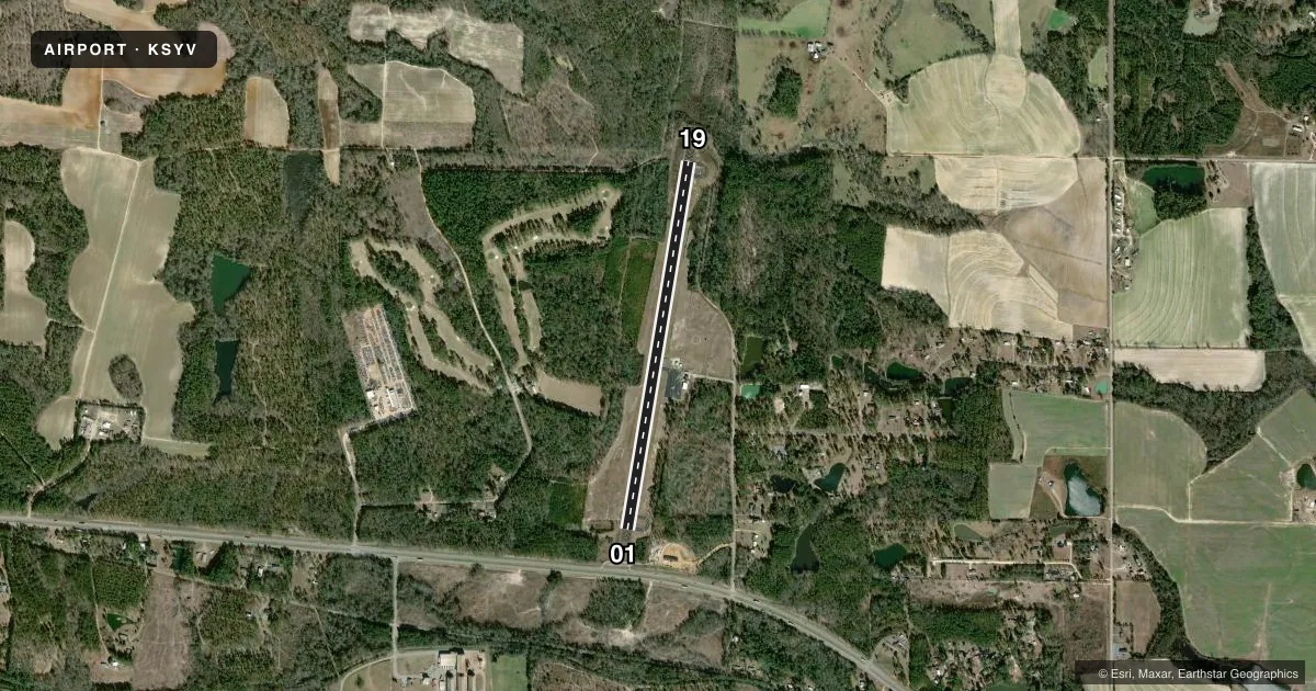
Airport sketch
Runways drawn to scale from FAA survey coordinates, rendered over satellite imagery. Not for navigation.
Approaches & charts
Services on the field
Fuel grades, oxygen, maintenance, ramp storage and lighting — as declared to the FAA by the airport operator.
Fuel & services
- Fuel
- 100LL
- Oxygen (bottled)
- Not available
- Oxygen (bulk)
- Not available
- Airframe repair
- Not available
- Power plant repair
- Not available
- Other services
- AGRI
Ramp & ground
- Transient storage
- Tie-down
- Landing fee
- No fee published
- Customs
- Not available
- Lighting schedule
- SEE RMK
- Beacon schedule
- SS-SR
- Beacon
- White / Green (civil land)(WG)
- Wind indicator
- Lighted
- Segmented circle
- Yes
Fuel & FBOs
Cheapest 100LL and Jet A on the field and nearby. Always confirm with the FBO before taxi.
Airport notes
Surface conditions, obstructions, local procedures, lighting outages and other notes published with each FAA cycle.
General notes
- DEER ON AND INVOF ARPT.
- FOR CD CTC JACKSONVILLE ARTCC AT 904-845-1592.
Lighting notes
- DUSK-DAWN. ACTVT PAPI RWY 01 & 19; MIRL RWY 01/19 - CTAF.
VFR map & nearby airports
VFR sectional. Tap any ICAO chip to open that airport.
Key facts · KSYV
Answer card- ICAO
- KSYV
- Name
- SYLVESTER
- Location
- SYLVESTER, GEORGIA
- Elevation
- 403 ft MSL
- Traffic pattern altitude
- 1,403 ft MSL (1,000 AGL)
- Control tower
- Non-towered (use CTAF)
- Total runways
- 1
- Longest runway
- 01/19 · 4,525 ft
- Published ILS approaches
- 0
- Published frequencies
- 2
- Magnetic variation
- 2°
- Current flight rules
- VFR
- Current wind
- 270° at 4 kt
- Favored runway now
- RWY 19
Sylvester Airport sits in Sylvester, Georgia. The field elevation is 403 ft MSL. It has one runway. Runway 01/19 is 4,525 ft long and asphalt. There is no control tower. CTAF and UNICOM are both 122.8. No ILS approaches are published here.
Pattern altitude is not published. For a light piston, plan on the standard 1,000 ft AGL pattern unless the current Chart Supplement says otherwise. That puts the pattern at 1,403 ft MSL based on the field elevation. Verify before you go if you need an exact local procedure.
There are no on-field FBOs listed in the facts. Contact the airport operator directly before arrival. You can also call the field on CTAF or UNICOM for current service status. Published remarks say deer are on and near the airport, so keep a sharp scan on taxi, takeoff and landing. The runway lights and PAPIs on 01 and 19 are active from dusk to dawn on CTAF. For clearance delivery, contact Jacksonville Air Route Traffic Control Center at 904-845-1592. If you are planning IFR, check the current Chart Supplement for the latest approach and airport details before departure.